Point of Ayre Lighthouse
[From Mate's Isle of Man Illustrated, 1902]
A cross Ramsey Bridge, and through North Ramsey, lies the route to Bride, Andreas and Jurby. Three trunk roads lead to the various parts of the northern plain. The turn to the right beyond St. Olave's leads to Bride ; the road straight on to Andreas ; and the left hand turn, beyond the windmill, to Jurby. All these parishes are one undulating plain of meadows, pastures and fertile arable lands. Rich beds of marl are found, and when wheat was more extensively grown, the marl was used as a fertilizer. The disused marl-pits are a feature of the locality. The Bride Road lies parallel to the North Shore, touching it at the Dog Mills. On the right, just clear of the town, in a fine situation on the brows overlooking the bay, is the Ramsey Hydropathic, a handsome and commodious place with delightful roamage from its very doors. At four miles out may be noted the farm of Ballavear, the home of George Quarrie, whose poem " The Melliah " (Harvest Home) entitled him to be mentioned among native men of letters. Bride Hills, a rampart of undulating dunes rising to the height of 300 feet and covered with the softest sward.
The view backwards toward the mountains is very fine from this point; and, indeed, from every point all over the northern plain. The mountain chain rises like a majestic island from a green sea of level plain; the ravines purple and brown with woods, the large crags grey and silvery, the vistas of the greater glens blue with vague mystery of shadows and grassy terraces vivid green in the full. glow of sunshine
Over the Bride Hills the road dips to Kirk Bride, the church, the rectory and half-a-dozen houses constituting the hamlet. Manx parishes have, strictly speaking, no villages, the clustered focus of parish life as in England. The original social systems were different. The old Manx system of small proprietors, scattered homesteads, and many small churches, gave place to a superimposed parochial system in ecclesiastical matters, which established a parish church but did not concentrate the population. The parish church consequently in two instances out of every three has not even a hamlet about it.
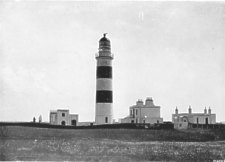
Point of Ayre Lighthouse
At Bride there are several fine fragments of runic crosses. The church is modern (1869). Stone circles and cairns of antiquarian interest abound in this district. Three miles beyond the church is the Point of Ayre with its noble lighthouse and fog-signal station. The Ayre is a broad low spit of shingle and sand covered with gorse, heather, grass and bent. Burrow Head, in Wigtownshire, is but fifteen miles off; and the Mull of Galloway twenty-one miles. The tide-way, or " streuss," runs very strong off the Point. Steamers pass within a cable length of the shore, and the beach slopes into deep water with alarming steepness. For sea-fishing of cod and conger the water west of the Point is the choicest ground on the coast. It will repay the lover of solitude to walk along the Ayre westwards, and enter Andreas by that route. There is also a good road from Bride Church to the west, and by the coast into Andreas, which also may be followed to Jurby and Ballaugh. The lighthouse may be seen by permission of the head light- keeper, whose civility may be safely counted on. Near the lighthouse recent borings have resulted in the discovery of salt, which promises to be a valuable source of profit. The little cove of Cranstal, a mile from the lighthouse on the shore of Ramsey Bay, is also more than worth a visit.
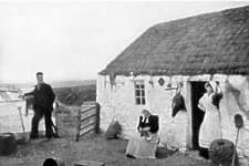
A Manx Fisherman's Home
The Manx fisherman's cottage and all its properties may here be seen in the most characteristics of examples. The people are generally of the Scandinavian type with the fine eyes of the sympathetic and emotional Celtic race.
THE. direct distance from Ramsey to Andreas is about five miles. Half-way out is the Dhoor. The plain towards the Lezayre Hills was once a lake, called Myrosco, or Lough Malar. An islet now Close-yn-Ellan (the close of the island) had a monastery, given by Godred II., (1176) to Silvanus. Abbot of Riveaulx ; transferred subsequently to Rushen.
Several cairns or cronks (burial tumulus) are visible on the more elevated spots through this district, but cultivation has, in the course of time, obliterated many others. Andreas Church and its detached Italian bell-tower are visible all over the northern plain. The church is modern (1872). Several invaluable fragments of runic crosses are preserved in the basement of the tower. The living is a rectory to which is attached the Archdeaconry of Man. Several roads branch off here ; and a few shops, an inn, post-office, smithy, school, and Wesleyan Chapel are located in straggling fashion on the main road. Two miles from Andreas, towards the coast is Ballawhane, in the early part of this century the residence of Mr. Teare, a " Fairy-doctor," whose practice was co-extensive with the Island. He used a MS. book, which, after his death, was found to be based on the work of Lilly, an English astrologer of the 17th century, with addenda based on tradition. The peasantry believed that Mr. Teare could make grass grow on the dusty high-road by moving his foot over it ; that on his journeys he availed himself of the use of an invisible steed ; and that he had the power of rendering himself invisible and visible at will.
The Western limit of Andreas is the Lhen " trench, probably at one time the debouchure of Sulby River, an exceptionally good trout stream, but with fly must be fished with a breeze. It enters the sea at the Lhen, where a gap has been cut by the waters through the rampart of grassy dunes that extend along the whole seaboard from Bride Hills, along the borders of Andreas, Jurby, Ballaugh, and part of Kirk Michael, except where broken by the overflow of inland waters or the ravages of the sea. The Lhen has a picturesque old mill of soft impalpable grey tone. It is mentioned in the Rent Roll (1513). The bridge is, like the mill, of mellowed grey. There are also some thatched cottages within the shelter of the dunes, and about them all the picturesque properties of fishing gear. The sward on the slopes is everywhere tender and elastic to the foot, and the aspect of the landscape conveys a suggestion of loneliness and the melancholy of the sea. The Lhen is the traditional landing place of King Orry. The Milky Way is called in Manx " Raad mooar ny Ree Orry," --the great road of King Orry, the tradition being that on his landing in Man he was asked from what country he came, and answered, pointing to the Milky Way, " That is the road to my country." The name Orry is an eponym, a personification or individualization of the last dynasty of Manx Kings, who were of the family of Godred or Gorry, and vaguely includes all Scandinavian and Danish invaders that preceded them.
AT the Lhen Bridge the coast road passes from Andreas into Jurby ; and this route may be followed. Otherwise, from North Ramsey the left-hand road called the Lough Mallow or Lough Malar Road strikes west, across the flats bordering Lezayre and Andreas, and then enters Jurby. It runs parallel to the Lezayre Hills at about a mile-and-a-half out on the plain. The flats now well cultivated and drained by trenches, the courses of which are lined with dwarf willows, but laid under water in heavy rains, are the former Lake Malar or Myrosco. Four-and-a-half miles out is St. Jude's Church, with a square ivied tower of good proportion. This church is modern, and is a chapel-of-ease to Andreas. Behind Ballachurry House, quarter-of-a-mile from the church, is Ballachurry Fort, formerly called Andreas Fort, erected by James Stanley, Seventh Earl of Derby. In 1651 it surrendered to the native Militia, under Captain Teare, of Jurby, and Lieutenant Ewan Curphy, of Lezayre. The fort had nine pieces of artillery. It is square covers half-an-acre of ground ; is surrounded by a wet fosse ; and has ramparts 12 feet high with corner bastions. The situation in a bog accounts for its excellent preservation.
The parish of Jurby is a small area ; and consists of a sandy plateau with rich beds of marl between the Lhen Trench, the flats of Lezayre, the Curraghs (or bogs) of Ballaugh, and the sea. The plateau is highest along the coast, where the scarped brows of sand and clay are constantly being abraded by the action of the sea. Midway of parish seaboard, the coast projects and the brows are highest at Jurby Point. On the top of the dunes, near the Point, is the church, visible all over the level country from Ramsey. It is dedicated to St. Patrick, but the present church is modern (1820), and has no attractive feature. It has a slender square tower, and being on the sea border is a landmark for fishermen by which to locate the best ground for fishing. In the middle of the churchyard is a prehistoric tumulus with large quartz boulders. Several runic crosses are preserved in the church ; and in the fields of West Nappin, close at hand, is an interesting ruinated church of older date. West Nappin belongs to the Clarke family, descended from Lieutenant Clarke, of Jurby, who was associated with Illiam Dhone (1651), and to his honour was ejected from the Keys in 1662, prior to Christian's trial. The principal seat in Jurby is Ballamoar, hidden among plantations on the landward slope fronting Ballaugh Curraghs. In this district may still be seen sod cottages thatched with bent, the best surviving examples of the old Manx cabin. The coast road from the Lhen, past Jurby, dips into a depression through which the Killane Stream, draining Ballaugh Curraghs, passes through the dunes to the shore. The Killane Mill is mentioned in the Rent Roll
Beyond the Killane is Ballaugh Parish and Ballaugh Old Church.

Ballaugh Old Church
THIS Church, though much altered, is old, the western facade, architecturally quaint but very fine in design, is of Bishop Wilson's time, the sole survival of his church building. The runic crosses found about this church are preserved at the new parish church (1835) near the modern village, a mile-and-a-half inland, near the hills. The font fixed in a recess in the wall is curious and was probably used for total immersion. Near the old church, across the stream, is visible the home of Prof. Forbes, the zoologist. The landscapes over the levels of the Curraghs backed by the mountain wall, softened in purple and blue are very fine ; and here, be it observed, that the colour of Manx landscapes is very rich. Especially is it so in Ballaugh,
Among the Curragh sallies
Shaking the perfumed gold-dust on the streams.
The old church is dedicated to St. Mary. Ballaugh is Baly-Lough or Mere-town. The old rectory, now a private residence, was the birthplace of Deemster Parr, the Blackstone of Manx law ; and of Canon Stowell, the orator of the Evangelical party half-a- century ago. His father, the Rector, was the author of " Ellan Veg Vannin Veen," the most charming of Manx songs, wedded to the old Manx air, the " Wandescope." Among the cultivated lands in the parish are large pools, called locally " polleys," a survival of the Norse, poll'r= a pool. For wild duck and snipe the Curraghs compare with the best shootings in Ireland. Between Old Ballaugh and modern Ballaugh is an ancient and most picturesque hamlet, " the Dollagh," with a foot-bridge of one immense flagstone. This hamlet is the ancestral seat of the Dollagh, who figure in Mr. Hall Caine's " Deemster." Mr. Hall Caine's ancestors, it may also be noted, belonged to the parish of Ballaugh, where in his boyhood he gathered much of the " local colour " of his Manx novels.
|
|
||
|
|
||
|
|
||
|
Any comments, errors or omissions gratefully received
The Editor |
||