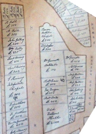
from 1842 plan
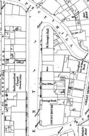
from 1867 O/S Plan XIII.12/2
The IoM P.R.O. holds a very large, hand-drawn, single sheet plan of Douglas , about 2m square, entitled "Plan and Valuation of the Town of Doiuglas 1842".
This predates by 25 years the survey of Douglas (& Ramsey) by the Ordnance Survey which produced a very detailed plan at 1:500 in 1867. However the 1842 though on a scale around 1:1000, is cadastral in nature in that each block of property, delineated by named streets, is numbered and individual properties labelled with a name of a legal owner or occupier/tenant responsible for paying any property tax or cess raised. According to an endorsement on the plan it was referred to in the case of Mathias Cain vs Leonard Heelis & Edward Kissack, Wardens of St Matthew's re liability to pay Church Assessment in Braddan in the Exchequer Court Nov 1842.
There is a note(underlinings on original)on the plan that
this plan represents the relative position of the several properties within the town of Douglas, as the same adjoin the public streets therein but does not lay down each property upon any accurate scale, and is not intended to represent the correct boundaries of the said several properties where the same adjoin each other in the rear.
An example is shown below - this shows the top of Athol street in 1842, at the top is Prospect Hill coming down from the barely developed upper Douglas - Victoria Street is still 20 years in the future. [the extracts have been skewed for ease of reading - Athol Street runs NE-SW
|
from 1842 plan |
|
At the top of the street on the right hand side is the old Methodist club rooms, later used as a theatre, converted into a Roman Catholic church - St Francis Xavier - in 1836; the history of this building is interesting - originally built.by the Methodist Friendly Society founded in 1798 which collapsed in 1813 following the scandalous circumstances of its funding of what became the National School further down Athol Street.
The Southern part, some 25ft 5in in length, of the club rooms, built in 1809 was sold, in 1815 for £304 to Robert Cannell(tallow chandler), one of the committee of the society, after attempts to sell the whole building fail [see above link] - it is possible that Cannell remined the owner and rented the premises to the church.
However in 1832 John Cowle and Thomas Callow both closely associated with the society sold the main part in 1832
CTD Hil 1832 46
[Douglas]dated 2 Jan 1832;John Cowle(Douglas) + wife Elizabeth and Thomas Callow(Douglas) + wife Jane sell for £680(British) to Thomas Crelly(painter, Douglas) that large house in Athole [Athol] Street called the Clubroom plus yard, stables, offices + buildings bounded by Philip Garrett(surgeon) on west, Athole street on north, highroad to Ramsey on east and south; Witt John Nelson, William Duff [see CTD Hil 1833 29b]
CTD Hil 1833 29b
[Douglas]dated 10 May 1832;Thomas Crelly(painter, Douglas) + wife Margaret sell for £680(British) to Revd Matthew Joseph Gahan(Kk Braddan) those houses in Atholl St called the club room with yard, stables etc adj Atholl St on north, high road to Ramsey on east + south and the rent of Philip Garrett on west - purchased by Crelly from Thomas Callow + wife by deed dated 2 Jan 1832;Witt John Duff, John Crellin
This sequencing of sales for property intended for Catholic churches was seen elsewhere eg in Peel as otherwise there was danger of being outbid for the property by anti-catholic protestants if it were known that the site was intentended for a Catholic church.
The property immediately south of the church has the name Galagher against it - no such name can be found within the deeds and the only instance of it in the Manx press in the period 1840 to 1842 is a note in Mona's Herald of 27th April 1841 (and copied by Manx Liberal of the 1st of May) is that the Rev Galagher R.C.P. of this town announced from the pulpit that he intends opening a branch of Father Matthew's [temperance] society. R.C.P., I assume, stands for Roman Catholic Priest which implies the building was being used as a Presbytery for St Francis Xavier's.
The church was closed in 1859 when a new church - St Mary's - was opened further along Buck's Road.
The group of three properties between Dr Garrett's stables &c (a plot that seemed to remained undeveloped in 1867) and the Oddfellows' Hall were sold in 1835 by the executors of Paul Bridson by deeds SSS Oct 1837 27,29 & 30 - all of which shared a plan
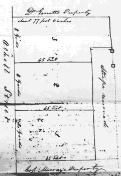 |
All three plots were sold on the 28 July 1835 - note there was a considerable difference in elevation between the ground floor level of Gt George street and that of Athol street - the reserved strip was intended as a pedestrian access to Gt George street - approached by a passage way and a set of steps to be paid for by the three buyers clearly shown on the 1867 plan - sometime during the long period when the Brown family ran their newspaper and printing business it was converted into a steep ramp allowing access for the large rolls of newsprint for the presses. SSS Oct 1835 30 covers the north-most plot - Thomas Ridgeway Bridson and Mary Ann Bridson, Sarah Bridson and Alice Bridson sell the plot of land marked '3' on the plan for £74(Brit) to Robert Cain(joiner, Douglas) SSS Oct 1835 27 covers sale of plot 2 to George Quiggin and William Karran(joiners, Douglas) for £70 SSS Oct 1835 29 covers sale of plot 1 to Robert Oates(ships carpenter, Douglas) for £60. In all three sales the purchaser could pay all up front or half now with an annual ground rent of 5% of the outstanding sum which could be fully discharged within the first 7 years or if not discharged within that time to remain as a fixed annual ground rent.- Cain opted for half up front and then a ground rent, the deed has notes by the registrar for the next 70 years of changes of the parties concerned.. George Quiggin bought out his partner and paid the other half a year later; Robert Oates would appear to have paid the full sum upfront. Quiggin's purchase became some years later the Douglas Post Office until this was moved in 1873 to the new and much larger premises in Regent St after which it was acquired by James Brown. |
The final property in Block 5 is another example of financial overreach by a friendly Society - in this case the Oddfellows.- more tba
The IoM Family History Society have 3 photographed copies derived from the large plan held by the PRO - these copies are overlapped segments of the plan, each labelled Douglas 1842 but are not direct copies - the streets are labelled in a different way, the style of numbering the blocks is different though the block numbers are the same. In addition to the names, some of which appear to be mistranscribed though this may be an artifice of the copying and subsequent wear as the copies were used as posters at their stall at Tynwald fair, each property is numbered within the block - these numbers are not postal street numbers.
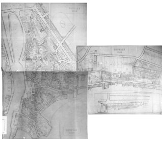
Composite of 1842 smaller plans - west to top
The discussion of these smaller partial plans is found under research work on Duke Street.
The background lies in the claims for damages arising from the Potato & Copper Riots of 1840. - a brief note
Manx Sun, Saturday, 17th September 1842
PROPERTY VALUATION OF DOUGLAS.
£60 having been appropriated to obtain the true Valuation of the Property of Douglas, and the duty having been assumed by Messrs. Robert Quiggin, Robert Cain, and John Radcliff, we may soon expect to receive from their hands a document of much value; useful as well to the practical business of the town, as to the future statistical history of the Island. If, as it is said, this work of valuation was rendered necessary to adjust certain disputes growing out of the potatoe and copper riots, it will more than verify the old adage, that "there is no great loss, without some small gain" — indeed, it will be a good which will remain, when the temporary evil shall have been forgotten.
By November the work had been completed
Manxman, Thursday, 3rd November 1842;
VALUATION OF DOUGLAS.
We have been informed that the gentlemen who were appointed by the Governor's order to value the property of Douglas, for the purpose of levying a rate to pay for the damage done in the late riots, returned their valuation to the Court of Chancery on Thursday last. The amount is estimated at £353,525, and the whole is comprised in 8,270 allotments. They also furnished to the Court a plan of the town, drawn upon a large scale, with every part and parcel of property therein laid down on it, with the respective values marked on each part. We understand it will be placed on record.—The plan was drawn by Mr. John Goldsmith, of this town, and does him lasting credit as a draftsman, for the comprehensive and perspicuous style in which it is executed.
The next mention of these plans would appear to be in 1848
Isle of Man Times, Saturday, 18th November 1848;
TYNWALD COURT.FRIDAY . Nov. 17.
... The large plans of the towns were again paraded in open court, and the same were authenticated by his Excellency and the Speaker of the Keys, preparatory to their being deposited in the Rolls Office.
The 1842 plan is sometimes stated to be that done under the Lunatic Asylum Act
Mona's Herald, Wednesday, 13th April 1864;
The SECRETARY said he had just been handed a petition from the Douglas Town Commissioners praying that counsel might he heard on their behalf respecting the Lunatic Asylum Valuation. The petition, which was read by the Secretary, is as follows :-
to THE HONOURABLE THE HOUSE OF KEYS.
The humble petition of the Douglas Town Commissioners sheweth: That by an Act of Tynwald, promulgated in the year 1860, for providing a Lunatic Asylum, provision is made for the collection of the rates for the erection and maintenance of the Asylum to arise from any town having Town Commissioners, by the Commissioners. That your petitioners submit that there is no reason why such duty should be cast upon your petitioners, but that such duty should he performed by a collector appointed for the purpose, and paid out of the rates so levied. That the said Act also provides that the expences of making the valuation of property throughout the Island for the purpose of the said Act. shall be paid out of the rates so levied; and it is provided that in case of the valuation having been previously made of any town under any Town Improvement Act, such valuation should be used as tbe valuation nnder the said Asylum Act. That the valuators under the said Act have adopted the valuation of Douglas made under the Town Improvement Act —valuation which cost the Town upwards of £130; and your petitioners submit that the town of Douglas should be exempted from contribution to the expence of the said Asylum Act valuation. That a bill entitled "An Act to provide a Temporary Lunatic Asylum" is now before the Legislature for consideration, therefore your petitioners humbly pray that the said Act may be so amended as to relieve your petitioners from the said duty complained of; and that the town of Douglas may be exempted from contributing to the expence of the said valuation ; and that your petitioners may be heard in support of this petition. And they will ever pray, &c.
This petition seems to imply that the ownership of the properties nearly 20 years later had been brought up to date and that property constructed since 1842 was also included.
|
|
||
|
|

|
|
|
|
||
|
Any comments, errors or omissions gratefully received
The Editor |
||