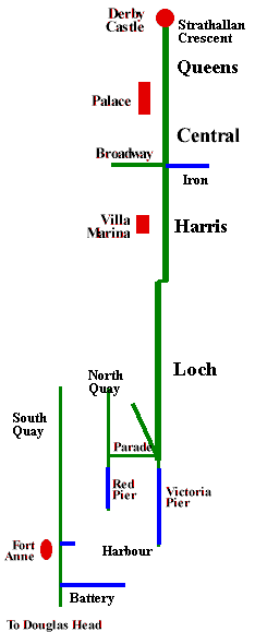
The figure (highly diagramatic) shows the relationship of the various promenades around Douglas Bay - all were products of the second half of the 19th Century when Douglas saw the major boom in tourism.
The old town of Douglas occupied a small triangle with two sides given by North Quay and the Parade (later Parade Street) with some development along the Sandside (Sand street - later Strand Street) which ran inside the later Loch Promenade.
The Loch Promenade, named after the energetic Governor Loch, built on reclaimed land opened in 1878, running from the end of Victoria street along the bay for some 2,500yards to meet the Ramsey road (a continuation of Duke Street and Strand street) - self financed by selling the reclaimed land behind the sea wall which was quickly occupied by terraces of impressive Boarding houses.
Victoria Pier had opened a few years earlier in 1872 and replaced the old Red Pier with its lighthouse as the main landing place, Victoria Street, opened 1875, cut through old Douglas to provide easy access to the new Pier .
An 1880 description has:
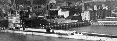
Inside the Lighthouse on the left is the Breakwater, which, with the approach to it, cost about £150,000. Farther in is the old Red Pier, where formerly passengers were landed. To the right is the Victoria Landing Pier, recently constructed at a cost of £59,000, and towards which the steamer is now pointing her head. To the right again is the Loch Promenade, another of the improvements recently effected in Douglas. On this Promenade, which is formed on land reclaimed from the shore, some magnificent terraces of houses have been erected. Some idea of the strides which Douglas as making as a watering place and Summer resort may be gathered from the fact that nearly half-a-million of money has been expended on public improvements alone during recent years, and nearly a million must have been expended on railways, new streets, shops, hotels, boarding-houses, and other private improvements. Extending from the Promenade, will be seen the Iron Pier, and beyond that again the magnificent Bathing Ground of Douglas, in which there are unequalled facilities for bathing. Beyond these, again, are Castle Mona, formerly the residence of the Duke of Atholl ; and under Onchan Headlands nestles the pile called Derby Castle. It will be seen that the old town of Douglas, in the form of a triangle, occupies the low ground at the mouth of the river
The Douglas Bay Tram (horse drawn) had commenced in 1876 and provided a convenient, and profitable, transport system around the Bay from Derby Castle, which had opened in 1877 as the first of the large Dance halls, to the foot of Victoria pier.
Harris Promenade, named after Samuel Harris, High Bailiff, who played a leading role in Douglas, was actually developed before Loch Promenade by levelling the land at the centre of the bay to provide a wide promenade . Though short, it became very popular - Harris gave it to the Town in 1868.
Queen's Promenade (after Queen Victoria), opened in July 1890, with considerable ceremony including 22 cars of the horse tramway in procession - this was some 573 yards in length and 100 feet in width. The short Strathallan crescent built by the Derby Castle company completed the arc.

