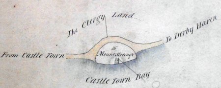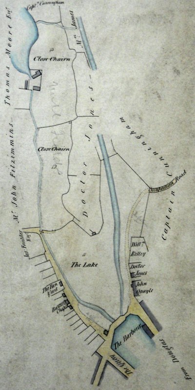
The plans in file MPE 1/1053 held in the UK National Archives have been discussed in the pages considering the Governor's Demesne and the George Hotel - this page looks at another section of MPE 1/1053-3 along with a second, slightly earlier, plan MPE 1/1059 titled "A Plan of Part of Castletown Harbour in the Isle of Man showing the Part above the Bridge claimed by Government". Neither plan is dated nor is any surveyor named but as MPE 1/1059 indicates a cholera hospital it must date from 1832 when this disease struck and as the pencilled annotation states in a section near the bridge "Site of School House granted 18th July 1836 rent 2/6" it must date it pre mid 1836. MPE 1/1053-3 shows a building on this site, though not named and somewhat smaller than that built as well as an un-named building at the site of the Cholera Hospital suggesting a date of c.1837 for this Plan. This plan also shows the Town Mill now at the end of today's Mill Street, presumably some unmarked cart track would have existed to reach it.
The Manx "Chiarn" - of the Lord - is rendered "Chairn" - cairn - in both MPE 1/1053-3 and the corresponding MPE 1/1075 showing lands near Peel.
from MPE 1/1053-3 |
The two fields comprising Close Chiarn (Lord's Close) were indicated on MPE 1/1053-1 as belonging to the Duke of Atholl - the MPE 1/1059 plan would appear to claim the land along the west bank of the Lake, which later was made into Hope Street.
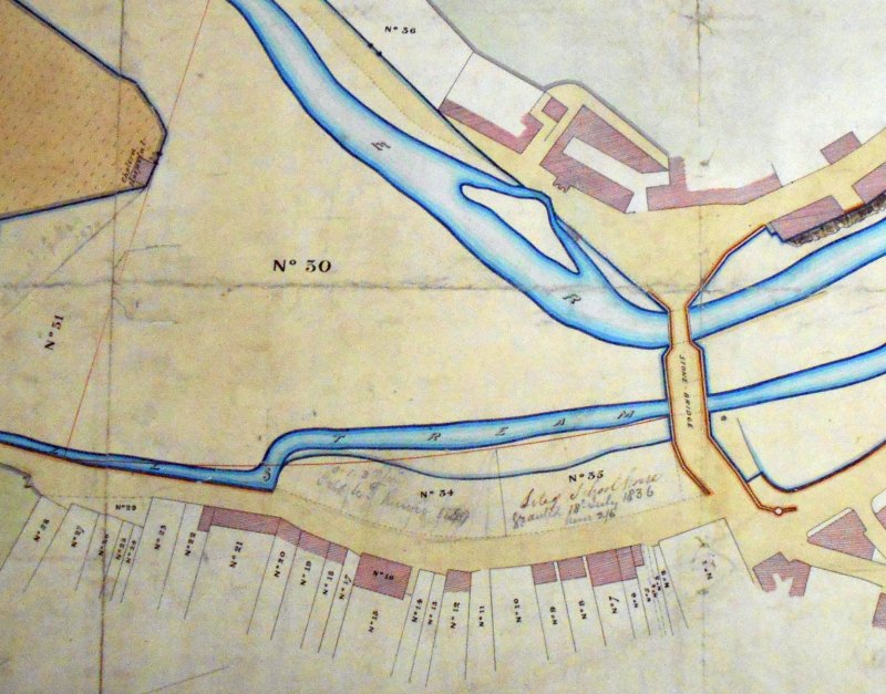
The numbers are keys into a table of occupiers, No 30 is the "Lake" partly flooded at high tides - the Cholera Hospital is at the tip of Dr Jones's land where it meets the Lake - it is shown on the other plan but not named there. At this period the road to Douglas entered the town along the boundary of the Taubman's Bowling Green estate, originally over a draw bridge but from late 18th century over a newly built stone bridge and a newly constructed Bank Street. The building, with an extension into the road, marked John Quayle above the bridge is the Castletown brewery. |
Named properties | |||||
---|---|---|---|---|---|
1
|
- Cannell | 13 | James Harrison | 25 | - Collins |
2
|
- Dinwoody | 14 | - Kinley | 26 | W Archer |
3
|
W Ratcliffe | 15 | - Cole | 27 | J Bell |
4
|
J Ratcliffe | 16 | Ranters Chappel | 28 | J Garrett |
5
|
H Quayle | 17 | John Qualtrough | 29 | - Quayle not yet enclosed |
6
|
L Corkill | 18 | -Layland | 30 | to be left unenclosed for the use of the harbour |
7
|
J Gelling | 19 | John Gale | 31 | | | }may be enclosed exclusive of River and Mill Stream | | |
8
|
R Quayle | 20 | Thos Kinvig | 32 | |
9
|
- Boyde | 21 | - Brew | 33 | |
10
|
Capt Kermode | 22 | W Kegg | 34 | |
11
|
R Quayle | 23 | J Lace | 35 | granted for building a school |
12
|
W Craig | 24 | - Curphy | 36 | - Killey |
In the field (marked 33) above No 30 is marked "Old Gallows" which stood along the river bank outside of the town. Feltham in his account of a tour in 1797 & 1798 mentions "A place of execution, which is adjoining the town, is, happily, seldom or never wanted; the Spirit of the criminal laws is mild, and the following are the only persons who I could learn had been executed. In 1735, William and James Clucas, and William Kelly, for burglary and robbery; and in 1740, John Bridson, of Ballasalla, for the murder of a young woman, who was pregnant by him". Feltham was somewhat sparing - a more complete number is available |
MPE 1/1053-3 also includes a small plan of Mount Strange
on the Derbyhaven road - Feltham also mentions this - . In the first report of the Manx Museum and Ancient Monuments in 1906 is " It was suggested that an effort should be made to have "Mount Strange," on the estate of Hango Hill, protected by a sea wall, as proposed by a committee of the Tynwald Court, in 1891". Very little survives today. |
from MPE 1/1053-3 - pencilled annotation "quite large fall '74" |
|
||
|
||
Any comments, errors or omissions gratefully received
The Editor |