Part of MPE 1/1053-1 somewhat enhanced
The UK National Archives hold a number of maps and plans that would appear to have been held by the Department of Woods and Forests which held several tracts of Manx lands acquired by the 1826 purchase of the Manorial Rights of the Duke of Atholl. Those of interest here are three related plans - MPE 1/1053-1,2 & 3.
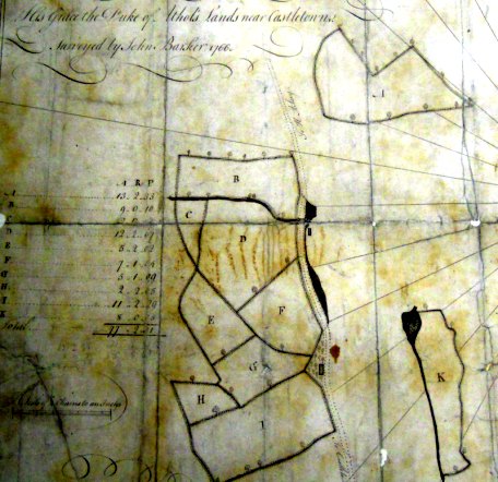
The first of these plans, drawn at 4 chains to the inch, is titled "His Grace the Duke of Athol's lands near Castletown. Surveyed by John Barker 1766" - AP52-5 notes he was paid £3 9s 8½d for this survery - the plan is damaged and stained, though not affecting the surveyed area - the image below has been enhanced.
Part of MPE 1/1053-1 somewhat enhanced
The plan is nominally North to the top, the road along the east side of the large group is actually the road from Castletown to Kirk Arbory, which runs SSE to NNW, the indented section adjacent to plot 'G' is Red Gap. The two isolated sections 'A' & 'K' are The Lord's Meadow and Close Chiarn [Lord's Close] lying along the Silverburn.
The tabulated areas of the B-F group are
| Acres | Rods | Perches | Field name | |
|---|---|---|---|---|
|
B
|
9
|
0
|
10
|
Doctor's field
|
|
C
|
2
|
0
|
[?]
|
The Meadow
|
|
D
|
12
|
2
|
7
|
Big Field + the Sheep Walk
|
|
E
|
5
|
2
|
2
|
Sour field
|
|
F
|
7
|
1
|
4
|
Brick field
|
|
G
|
5
|
1
|
9
|
Garden field
|
|
H
|
2
|
2
|
5
|
Little Meadow
|
|
I
|
11
|
2
|
29
|
Style field + Briar field
|
| total |
55
|
3
|
26 + [?]
|
The identification as the Governor's Demesne comes from a letter also held in the UK National Archives in SP 48/1/p186 in which Governor Wood in a letter dated 28th August 1766 discuses the implications of the Duke of Atholl claiming the land used in the past by the Governors "I shall therefore now be under the necessity of renting the house Gardens &c at what the Duke of Atholl shall think proper; as also the Demesne, consisting of 54 Acres, for which all preceding Governors paid a trifling acknowledgement of about seven pounds yearly - The Duke of Atholl will, no doubt, now demand Rent from the 17th May 1765, as he intimated that from that Day, all Expences of Government devolved to the Crown". He was correct the Duke did indeed request a significant rent - Governor Wood had great difficulty in getting paid by Whitehall - often three years or more in arrears, at his death in 1777 his widow was owed over two years unpaid salary.
The same area appears along with other small areas in MPE 1/1053-3, the third plan of this folder, entitled "Lands at Castletown", no surveyor or date is given (there is also "Lands at Peel" in MPE 1/1075 with a similar structure of small plans which appear to be by the same hand) however as it shows in the part above the harbour the location of the National School (now St Marys in the Harbour) it must date post 1836 though some sections may not reflect late changes.
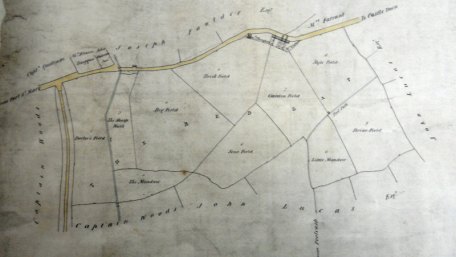
Here East is towards the top - fields are named and areas and usage given in a table - two of the field of the 1766 plan appear to be divided. The areas of the fields differ between the two plans, sometimes up to 2 acres difference.
|
|
||
|
|
||
|
|
||
| Any comments, errors
or omissions gratefully received The
Editor © F.Coakley , 2023 |
||