[From Proc IoMNHAS vol 1]
Following the programme adopted on their appointment, the Committee have during the year past continued their work with respect to Class 1. of Manx Antiquities, viz., the ancient Churches, Keeills or Chapels, and the Rhullicks or Christian burial-grounds.
Being handicapped by want of funds required for the publication of their Report, as well as for the actual work of excavating, they confined operations to one parish only. that of German, and have now, so far as this class of Antiquities is concerned, practically exhausted one out of our six Sheadings, viz. :-that of Glenfaba. They hope, however, to have an opportunity of returning to make a more exhaustive examination of the large enclosure at Rhaby, in Patrick, and further enquiries with respect to some of the sites of Keeills now long since destroyed. Since the last Report was issued they have ascertained the site of Keeill Vout, Parish of Patrick, which, as surmised (First Report, p. 19-see also Proceedings, New Series, Vol. I., No. 7, p. 291), was that stated by Vicar Holmes to be on Ballahig. It stands, in fact, on a small triangular easement of the old road leading from the Hope at Kenaa to Glen Elly and Foxdale, on the Treen of Ballahig,* but not on that Quarterland, as the land here is Intack ; the Northern hedge of the road is the boundary of Ballagarman, and, if we may suppose that this farm derived its name from that, now lost, of the Keeill, as in the case of Ballingan, Marown, and Ballakillingan, Lezayre, it suggests a dedication to the same Saint as that of our Cathedral and of the adjoining parish of German. Very little remains of the building, but Mr. R. Lace, who is now excavating and examining it on behalf of the Committee, has found traces of the West wall, and of the paved floor within, also of the East wall with indications of the Altar. Two fine stones were standing near by some years ago, but only one, which is broken, can now be found. The Ballameanagh Keeill, mentioned on the same page, appears to have been entirely removed between the time of Mr. Holmes' report. (1860) and the making of the Ordnance Survey (about 1864), as it is not marked on the latter even as a " Site of Keeill." We have, however, been able to ascertain its position, which should be O S. XII., 4 (2995) about 560 ft. above sea-level. The field is still known as the " Chapel Field," and Mrs. Lace and others remember the walls standing, and several headstones of graves around. The stones are said to have been used for buildings on Kionslieu, just opposite. On p. 18 of the same Report it is stated of Keeillwoirrey, Glen Needle, Kerroodhoo, that a portion of the North wall is still standing. Mr. Lace has now cleared and exposed the foundations of the whole building. It measures 24 ft. by 12 ft-, and has the doorway at the West end. The foundations at the level of the outside surface are 4 ft. wide, formed of large flat stones, apparently quarried in the neighbourhood, a rectangular one at the S. E. corner measuring ft. by 3 ft., along with a narrower one on its outside, occupies the full width, the wall rising above them at the reduced width of 3 ft. 6 in.; another at the S.W. inner corner is 5 ft. 6 in. long by 3 ft. wide. Besides the North wall, which is fairly complete, rising to a height above the floor level of 4 ft., portions remain at the N. W. and S. E. corners. They are built of stone throughout, in irregular courses, but a white and, in some parts, red plastic marl was used as a cement ; against the outside of the South wall was a row of large boulders, evidently in connection with the bank generally found round these buildings, and inside, near the East end, two large slabs on edge, one measuring 5 ft. 2 in. by 18 in., and about 7 in. thick. Possibly these may have been to support the floor, as they appear to serve no other purpose. The wall at the East end is straight at the ground level, but, below, it had been built into a curve which at either end projected inwards for 10 in. ; this may have been to strengthen the foundations, as the ground falls rapidly in this direction. No trace of an Altar was found At a depth of about 12 in. below the floor pavement, the level of which is shown by several stones projecting from the sides, were found at the East end seven lintel graves, side by side, all about 6 ft. in length and from 12 in, to 14 in. wide, and 10 in. to 13 in. deep, made of small and very thin slabs, most of them having two quartz boulders above the little slab at the foot ; they were nearly all lined on the bottom as well as covered by small slabs. One at the N.E. corner, immediately below the floor, was found to rest on the top of another ; in only two were remains found, viz., parts of a leg bone and of a skull, which were very fragile. The rest had crumbled away, and nothing appeared to have been buried with the bodies. The total number of graves now found was 17, including three outside the Keeill, one partly under the doorway. One was beneath the North wall, and two outside were touching the North wall ; possibly the whole area of the Keeill was so occupied, the rest not being examined. Many similar graves had previously been met with in widening and deepening the entrance to the farm yard North of the Keeill, and the side-stones of some eight or ten are still visible at some distance to the North and East of it, the cemetery extending northwards for about 6o yards. The name of the Keeill is perpetuated in that of a field across the road on the West, which is thought to have formed part of the grave-yard ; it is still known as Bwoailley Voirrey. The late Mrs. Cannell, Balla-carnane, remembered the gable standing, with "two long narrow , windows," probably the East gable with a window of two lights; that, we were told, would have been about eighty years ago, i.e., 1830.
As it seems likely that in the case of each parish further information may be received after the interim Reports are published, the Committee think that the most convenient course will be for them to take note of any such additional details and publish them all together as a supplement to the whole Report when the particular class of antiquities to which they refer will have been examined throughout the Island.
A hope was expressed in the First Report, p. 4, that a separate Memoir on St. Trinian's might be supplied in the form of communications to the Natural History and Antiquarian Society. This has since been done by the Rev. Canon Quine and Mr. P. M. C. Kermode in connection with the visit of the Royal Society of Antiquaries of Ireland, and will appear, with illustrations, in the Society's Proceedings and Transactions in due course. (See Vol. 1. New Series, No. 7, pp. 328 and 332).
Mr. C. H. Cowley, of Peel, Secretary to the Sub-Committee for this Parish, has given us some useful information and great assistance in obtaining permission to have the examinations made. So far as we have been able to learn, the following is a complete list of the Keeills in German, taking them from the north and working southwards : —
1. Foundations of Keeill Pheric-a-dromma, on the Quarterland of Corvalley, and the Treen of Sandall.
2. Site of Keeill on the Quarterland of Cronkbane, Treen of Scarrisdale.
3. Site of Keeill and Burial-Ground on Knocksharry, " No. 4," Abbey-lands.
4. Foundations of Keeill on the Quarterland of Ballahimmin, Treen of Lambfell.
5. Foundations of Keeill on Eary-Moar, Treen of Airyrody.
6. Site of Keeill and Burial-Ground on Beary, Treen of Balla-doweraghan.
7. Keeill Moirrey, Crook Keeillane, on Ballalough " Particles."
8. Site of Keeill 230 yards S.E. of St. John's Church, and about the same distance S.W. of the Parsonage, Quarterland of Ballahowin, Treen of Balladoyne.
9. Ruins of Keeill with Burial-ground on Cronkbreck, Treen of Alia Greeba.
10. Site of Keeill and Burial-ground about 70 yards W.S.W. of Greeba Mill, Quarterland of Kerrowglass, Treen of Alia Greeba.
11. Site of Keeill and Burial-ground on Kerrowgarroo, Treen of Alia Greeba.
12. Ruins of St. Patrick's Chapel, on Peel Islet, 30 yards North-East of the Round Tower.
13. Ruins of Chapel (?) Peel Islet, 20 yards north of Round Tower.
14- Ruins of St. Patrick's Church, Peel Islet, 20 yards due east of Round Tower.
Besides these ruins or certain sites of Keeills there would appear to have been a burial ground on the western edge of the natural plateau on which stands Tynwald Hill, about 193 yards west-south-west of the mound. This is not marked on the map, but would be O.S. IX., 2 (2693). Here, at a height above sea-level of about 145 ft., lintel graves have been found in ploughing, and from the description given of them by Mr. Mathews, and the stones found it, them, now tying in the hedge, they appear to have been Christian ;* but if there was an early Christian cemetery, there would almost certainly have been a Keeill in association with it. The Quarter-land is that of Ballahowin, Treen of Balladovne. At about 160 yards to the W.N.W., on the eastern brink of the same plateau, an undoubted Christian lintel grave was found by members of the Committee. This is at the north-east end of the enclosure (2706) ; the bank extends here from the present Church of St. John's, and a little northwards, in the enclosure (2679), turns to the west. In this latter field many graves have been found at the same level (about 15oft. above the sea), and from the description given by those who saw them, as well as from some of the stones with which they were formed, now lying on the hedge, it is evident that they were of the same type. Mr. Lowney, who is about 75 years old, told us that he remembered seeing many graves of a similar character within the Tynwald enclosure (2702) all along the line of the northern batik to the pathway from the Church to the Mount, when excavations were made for the present walls, but none were to be seen south of that. The grave opened and examined by the Committee lay approximately east and west, and measured 5ft. 6in by 14 in. and 9in. deep. The head and sides were formed of thin slabs of local stone ; at the foot were two boulders in place of a slab, and Mr. Faragher, the tenant, said that was what he had noticed with respect to many of them ; it was covered by about seven stones across the top. and the bottom was not lined. The body had been laid upon its back with the arms across the breast ; the bones were much decayed, and there was nothing otherwise to indicate the age of burial. The enclosure around St. John's is not now used for burials, but that it was so to the beginning of the 19th Century is shown by a broken tombstone built into the hedge opposite Tynwald Hill, with the remains of an inscription reading — " their son who departed this life 15th Jan'y 1802 aged 32 years."
[The Manx name for the Hill itself is Cronk-y-Keeillown, i.e., " Hill of St. John's Church." The use of the word Keeill and not Kirk seems to show that this name is older than Scandinavian times, and to imply that there had been a Church before the 11th Century. The broken cross-slab in the porch speaks of the Church in the time of our Scandinavian Christianity — say from 1030 to 1200].
Another burial place which may have been the site of a Keeill is that at Ballacraine, marked on the O. S. IX. 2, (2879), "Burial-Ground (Remains of)," This is about 155 feet above sea-level ; the highroad from Peel to Douglas, close to the junction with the road to Foxdale, here cuts through a natural gravel mound in which lintel graves have been found. When adding to the buildings on the other side (north) of the road some years ago, three skulls were exposed, showing that the Cemetery had been a large one. The mound is now about 33 yards in diameter. The Treen is that of Balladowraghan.
The Manx Chronicle gives two references to Battles of Tynwald, in 1228 and in 1238, and some of these graves are probably due to them.
Graves, — probably pagan however, — were many years ago exposed in making an addition at the back of a cottage on the Quarterland of Kerrowchord and Treen of Alia Knebe, standing on the North side of the highroad, nearly opposite to the road leading to Curragh-glass. The cottage is marked O. S. IX. 12, (3071), and is about 175 feet above sea level ; an extension was made at the back by the father of Mrs. Shimrnin. who now lives there. over stone graves, some of which are said still to remain. There is no tradition of a Keeill, and it is the less likely to have been the site tlf one as it is so close to those at Cronkbreck, Kerrowgarrow, and the Greeba Mills.
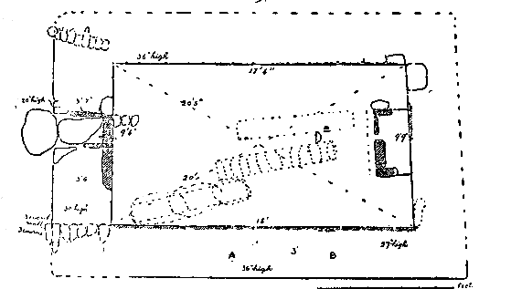
KEEILL PHERICK A DROMMA, i.e., St. Patrick's Church on the hill, is marked on the O. S. VI, 16, (392). It stands about 700 yards S.S. W. of the farm house of Skerestal-beg, on the South side of the road from Kirk Michael to St. John's, at almost the highest point, which is here 600 ft. above sea level. It is in the North-East corner of the field, just inside the gate, and presents the appearance of a mound, almost circular, with diameter at base of about 20 yards, rising abruptly from the present level of the field to a height of Oft. 6 in, at the East end, and at the West to 5 ft. 6 in. The position of the Keeill is exactly shown on the O.S.; it is distinguished by a low mound within the outer embankment, into which it merges on the West and round the North-West corner.
Fig. I. — Scale 1/8in.=1 foot. Keeill Pheric-a-dromma, German.
Upon excavating, the foundations of the Keeill were found to be at such a depth from the top of the embankment as would bring them to a level with the ground outside. The building, which measured 18 ft. by 9 ft. 6in. — (see Plan Fig. i) — was of local surface stones, undressed, and irregular in size and shape. One large one, 5 r in. by 1 r in., and about 6 in. thick, crossed the doorway, making a rather high sill and step to the interior ; possibly, as at Cabbal Druiaght and Keeill Vreeshey in Marown, the height had been reduced by a step inside now lost. A small proportion of quartz boulders had been used in the building, but the greater number of the stones had long since been removed. There was no trace of a window, what remains of their walls being below their level. The doorway was about the middle of the west wall. The south jamb remaining in position at a point 4 ft. 6 in. from the S. W. corner, measured 15 in. high by 22 in. long, and 2 to 4 in. thick, almost upright, and at right angles to the inner face of the wall ; an outer stone laid flat in a line with, but about 4 in. back of this, measured 16 in. by r 1 in., and 3 in. thick. The removal of a large boulder with which the space had been blocked, and excavation to the level of the floor, showed the doorway to be 19 in. wide inside, and about 23 in, outside. It was then seen that the outer corner-stone was laid upon two others, 14 in. by to in., and 12 by 8 in., each being 5 in. thick, The North side revealed an outer corner-stone 12 by r r in. by 4 in., resting upon three others, the lowest of which was 7 in. by 24 in. by 6 in. The total depth of the doorway, 3 ft. 7 in., was made up on this side by four such stones built in courses, and faced by a slab 26 in. long and 3 in. thick, the upper edge of which was on a level with the top of the step. Three round white pebbles were met with in the doorway, which, at a depth of 12 in. from the top of the step was paved with a flag 3 ft. long, joining another of about the same size which extended outside. The west wall, 3 ft. 6 in. wide, was constructed of a facing about 12 in. deep of stones outside and in, and packed with soil and some small stones ; it now stood from 19 in. to 30 in. high. Of the north wall only, the inner face remained, but for the greater part reduced to its lowest course, at the west end rising to 36 in. high, consisting of seven irregular courses of small stones. Of the east wall, about 30 in. wide, only a few large facing stones remained. The foundations of the south wall were about 30 in. wide, and from 18 to 27 in. high, showing; a built facing inside and out, packed with earth. The lower courses were faced inside by a skirting of stones set on edge, from g in. to r r in. high ; above these there remained two or three courses of stones laid flat ; both the north and south walls had a slight curve outwards of from 4 to 5 in., which might have been caused by settlement. Only the south and west walls retained their facing of upright stones, and the south-east corner, which was square, was the only one from which the outside stones had not been removed.
Against the east wall were found the remains of the altar, 4 ft. long by 23 in. wide ; a projecting stone at the north end suggests that there had been a step about 6 in. wide, in front. The remaining altar stones were arranged at about the level of the foundations of the walls, as follows : — at the N. W. corner a stone on edge r ; in. by 4 in. by 13 in. marked the north side, its end being on a line with the western base of the altar ; this was supported outside by a stone laid flat Sin. by 6 in. wide, and i r in. deep, Next came a thin slab set on end, 30 in. by 13 by 2 in., and on a line with it, a stone with the face sloping outwards, 21 in. Ion by 7 in. thick, and 7 in. high ; an upright stone, 1 5 in. High, by 7 by 14 in. deep, formed the other corner and the south side of the altar; the space within was packed with earth and a few small stones.
The only remains of floor pavement met with in position were three small slaty stones in front of the doorway ; another was found about 3 ft. in front of the altar. Beneath the floor of the Keeill, at a depth below the foundations of about 12 in., three lintel graves were found. One stretching diagonally from a point 12 in. from the S. W. corner, measured 7 ft. long, r r in. deep, and 12 to 14 in. wide ; it was covered by three large slabs overlapping, 39 in. by 21 in. by r in. thick, 35 in. by 20 in. by 3/4in., and 24 in. by 14 in. by r in. The side-stones, overlapping, measured 16 in., 28in. and 48 in. long, by about r r in. high, and an inch thick ; the bottom also was paved. These stones appealed to be local, unhewn, but carefully selected, their under surfaces had a peculiar knobly appearance showing the bed of the rock, and they contained a goodly proportion of iron. At this corner the soil was wetter than the rest, possibly this and the rather stiff clay had helped to preserve the bones ; the skeleton was seen to lie on its right side, facing south, the left arm crossing the body ; the skull had been pushed forward by the partial falling in of the endstone ; its upper part remained, and showed a low forehead with prominent brow ridges. The femur (decayed at the lover end) measured 175/8in ; the bones had almost decayed away, some of them completely so, and nothing was found buried with the body which might have served to indicate its period. North of this another lintel grave, its side overlapping the E. end of the first by 24 in, , extended 7 ft. in about the same direction to a point 30 in. west of the face of the altar; it was 12 in. wide and the same in depth, the east end stone 13 in. deep and 15 in. wide. It had three large side-stones and was covered by 12 small flat stones crossing it ; these had been partly crushed in, and both ends had fallen westwards ; nothing but earth was found inside. At twelve inches to the north of this a third lintel grave was found at the same level, entirely crushed in and filled with earth. In the midst of the Keeill were layers of bright red clay and wood ashes, about 2 in. thick, and from one to three inches apart, the lowest being three or four inches above the level of the floor. Could these have been caused by the burning of the thatched roof of the building, or were they due merely to burning gorse and briars here when the roadway was altered ?
Across the west wall, and laid upon its present ruined surface, i:e., at a height of about 30in. from the foundations of the Keeill, appeared some walling which proved to have been just the facing of an earthen bank built probably for temporary use as a sheepfold. This extended westwards for five feet in a line with the inner face of the south wall of the Keeill, having a width of single stones from 8 in. to 24 in. At a distance northwards of 10 ft. 4 in. was another similar facing of stones, consisting of three courses, about 12 in. high, and extending 4 ft. 4 in., with a slight curve to the north. The present enclosure which has a S. E. aspect, and is now about 20 yards diameter at the outside foot of the embankment, is greatly reduced in area. It occupied high ground but was not artificially raised. A lintel grave found when ploughing the adjoining field, about 30 yards to the N E. of the Keeill, and two others exposed in the middle of the present road, about 30 yards west, as well as the fact stated by Mr. Cowley, that the highroad men found " several stone coffins, with bones, on both sides of the highroad," show that its diameter in this direction must have been over 70 yards ; the ground slopes to a well-defined hollow. about 22 yards south, which remains to mark the line of the old road before the Quayes of Stockfield had it altered to its present position. At the foot of the hedge, about 9 yards west of the Keeill, was found another lintel grave lined with small flags on the bottom, ends, and sides, and covered by about twelve small flat stones crossing it on the top ; it measured only 4 ft. long by about 14 in. wide and 10 in. deep, and may have been that of a child, but was now empty except for the soil which had percolated through. Nine quartz pebbles were met with in the Keeill, three in the doorway, two above the grave at the west end, and the rest near the altar. In covering it in again, we set a large white boulder immediately under the sod directly above each of the inner corners, so as to mark its position.
CRONKBANE or KNOCKBANE. The site of this Keeill is marked on the O.S. VII, 13 (718) ; the name is lost, but the field is still known as the "Chapel Field." It is on the north side of the highroad to Cronk-y-Voddy, about 17 yards from the road, and 83 yards N. E. of the field gate, at a point about 550 ft. above sea level. Several people remember the final removal of the foundations and ploughing of the site ; among others, Mr. Corlett, Ballacorlett, told us that this was about 30 years ago, adding that the stones from it were placed along the eastern side of the lane leading into the field. Here they may still be seen, a melancholy memorial, showing the character of the building material. They consist of about 100 local surface stones averaging 2i in by 19 in. by gin., polygonal and irregular in shape, undressed. A number of sub-angular white quartz boulders average about 12 in. by 9 by 8 in.; and there is a great number of small flat surface stones — the group altogether extending for about 50 yards.
Nothing remains to mark the site, which has a northerly aspect ; at one time a roadway appears to have passed by it from Ballig. The O.S. shows the diameter of the mound to have been at that time 40 ft. by 25 ft ; evidently it had already (about 1884) been greatly reduced by the plough
KNOCKSHARRY. J This site, marked on the O. S. VI. 15 (252), is about 133 yards W.S.W. of the smithy — on the south side of the highroad from Kirk Michael to Peel, at a height of about 225 ft. above sea level. The name is lost, as also is that of the Treen.
The raised plateau now reduced to a triangular area about 125 ft. N. and S., by 6o ft. E. and W., is a natural bank of gravel, and has never been under the plough. Mr. Quirk and others remember graves being met with in ploughing the field the other side of the highroad.
BALLHIMMIN. O.S. VII. 13 (813. The remains of this Keeill are on a conspicuous mound about 165 yards N.E. of the ruins of the old farmstead, and about 630 ft. above sea-level. The place can be most easily reached from the ford on Rhenass farm. The mound stands now against the north hedge of the " little Chapel-field," that across the fence being known as "the big, Chapel-field." The name of the Keeill itself is lost. Nothing remains but the foundations, and even from them many of the stones have been removed, but the dimensions appear to have been about 15 ft. by 9 ft. The mound stands with perpendicular edges about 6 ft. above the surface of the north-east field, and from 7 to 8 ft. above the other, and the foundations were met with at a. level of 3 ft at the north to 6ft. at the S.E. The walls are of local surface stones, unhewn and undressed, with many boulders of white quartz ; the S.W. corner is best preserved, and shows very distinctly the mode of building ; the wall here about 2o. in. high, is of great width, from 4 ft. to 5 ft.; it was, at least for a height of about 2 ft . practically an earthen bank with facing inside and out of single stones, 16 to 18 in. deep, built in random courses, the space between packed with earth and having here and there a long flat stone as a binder ; some large stories also are set on edge. It is nicely rounded, both in to the doorway and at the outer corner, and being entirely of glittering white quartz. which the weathering keeps free from moss and lichen, would be conspicuous from a distance. The average size of the lowest courses of stones, inside, throughout the walls, is about 17 in, high and 15 in. wide ; around the foundations they have been lined with thin upright slabs from 14 to 18 in. high by 3 in. thick, but most of these have been removed, except from the north wall, where they are complete. At the east end similar upright slabs have been set against the foundations outside also. The north wall is now about 25 in. high above the floor, the east 30 in., and the south 36in., and they appear to have been all from 3 ft. to 3 ft. 6 in. wide. The doorway was in the west ; the foundations of its south side remain, built of quartz boulders ; it appeared to have been about 23 in. wide outside, as shown by the length and position of a stone set on edge, but the north jamb stones and inner sill-stones were gone ; the passage through it had been paved and formed a step of 9 to 12 in. to the interior. The floor also had been paved with thin polygonal slabs, of which several remained in position, averaging about 18 in. by 13½ in. The outside of the north-west corner had been picked away, and if, as seems likely, there were steps or a sloping paved path from the doorway, it had now disappeared. A curious thing was that at the N. W. corner there appeared to have been another doorway. The skirting of upright stones along the north wall, ended at about 2 ft. from the corner, and, upon clearing the foundations here to ascertain its width, the wall was found to have come to an end. Only two courses of stones remained, but they were distinctly built to form a face ending the wall, and had every appearance of being a part of the original structure. Between this and the corner, on a level with the floor, were stones having the appearance of pavement, and this was found to have been continued at a slope, with steps, 18 in. wide for a distance of 8 ft., the sides being marked here and there by quartz boulders This paved path terminated at a height of 2ft. above the level of the field, where it had been cut off by the fence now built up against it, At a point 32 in. in front of the east wall a large slab on edge appeared to have formed the face of the altar ; it measured 54 in. 10119, 24 in. above the floor, and 4 to 8 in. thick ; a piece had been flaked off the top by the pick when it was discovered ; it looked as though it had been moved out of position, standing at a distance from the north wall of 4 ft. 4 in , but touching the south wall ; it crossed another upright slab 2 ft. high, which appeared to have formed the south side of the altar, standing at a distance from the south wall of 18 in. The space between the large slab and the wall was filled in with earth and small stones, and when these were taken out it had the appearance of a cist.
The mound which now measures 50 ft. by 30 ft. diameter outside, rises so abruptly from the level of the surrounding land and looks so artificial that the Committee decided to test it. An excavation was made across in front of the large stone on edge, which was found to have a total width of 3 ft. 10 in. At a depth below the floor pavement of about 3 ft. the undisturbed soil of the original surface was reached — a loamy marl of an ochreous yellow ; the filling in above this was a red sandy soil with many quartz boulders. Nothing being discovered here except traces of wood ashes, a trench was dug for the length of the Keeill between the middle and the south wall. From 6 to 8in. below the paved floor was a layer of hard " black rock" thinning away towards the north and the east ; this was heavily charged with iron ; immediately below this layer was a close packing of quartz boulders for a further depth of about 10 in., among which, near the S. W. corner was a small quantity of charcoal, with broken fragments of thin pottery. Further traces of pottery were met with eastwards at the same level, consisting of streaks of bright red clay almost dissolved away. In the midst of the Keeill, at a depth below the floor of 2 ft , was an undisturbed pile of calcined bones in the red soil, unprotected except by the quartz boulders around it ; north of this the black rock disappeared and nothing was found. An excavation was then made between the large upright flag and the east wall ; below the white quartz stones, which appeared to be the base of the altar, others of similar character were found supporting theta to a depth below the floor of 3 ft. ; a few inches below this another pile of calcined bones was met with, evidently undisturbed, and lying in the red sand unprotected by stone or by pottery. In each case the bones were minutely examined for any article of bronze or flint, but nothing was found. A little northwards, at a rather higher level, some charcoal was met with also loose in the soil.
It is quite clear therefore that there had been a large artificial mound on this site, raised to a height which had in the course of centuries settled down to about 4 feet, in which were burials of the Bronze Age. At a later date the site was selected for a Christian Church ; and it looks as though the great stone set on edge, being found to be in a convenient position for the purpose, was intentionally left, and the east wall built at such a distance from it that it might serve as the front slab of the altar then built of quartz boulders between it and the wall ; the stone pavement shows what was the level of the floor at that time. Had the flagstone been set there when the Keeill was built it would have been placed opposite the middle of the wall and not have been at such a great depth below the floor, and there would have been traces of disturbance of the soil and stones below. Probably most of the large white quartz stones used in the building were derived from the Bronze Age Tumulus. Two worked flint flakes were found, 1 in. and 2 in. long ; the first was the butt end of a broken flake 1 1/4 in. wide, with remains of one cutting edge worn by use, the other, 1 1/8in. to 1 1/4 in. wide, shows two cutting edges and a rounded point, one edge has a small hollow carefully chipped, of a size to fit an ordinary pencil, and was no doubt used for scraping and polishing arrow-shafts. Another small flake was subsequently found, and a broken piece of flint. For the first time in one of these Keeills, we found two stone pegs, evidently, to judge from their appearance, B''whid Suggane, which would be set in the walls to fasten the ropes which held down the thatch of the roof. Graves had been met with when ploughing in the fields both N. and S. of the Keeill. About a dozen shore pebbles were met with, some of them below the paved floor.
The aspect of the site is about West.
EAREY MOOAR. O.S. X, 1, (1645). This Keeill stands, about 55oft. above sea-level, in a field above the Glen Helen plantation, from which it can easily be reached. The site is about 160 yards N.N.E, of the house, and 130 yards S. of the river, — 45 yards S. of the plantation. Only the foundations remain, measuring about 14 ft. by 7 ft. The walls are from 3 ft. 6 in. to 4 ft. wide and now stand from 2 to 3 ft. above the foundation which is deeper on the N.side owing to the contour of the surface. It is built as usual of local surface stones, but instead of an earthen bank merely faced with stone, the walls are of stone throughout, a little earth being used as packing. As there is a very great proportion of white quartz boulders in the building it must have made a conspicuous landmark. The doorway, 22 in. wide, was in the middle of the west wall, the interior of the Keeill being reached by a step about 9 in. high as shown by some white quartz boulders in position, but the sill-stone, if any, had been removed. No pavement stones were certainly in position, but many were met with which appeared to have their ends chipped to a round ; they averaged a little over 8 in. by 5 in., and were from 1/4 in. to 1 in. thick, a very few being between one and two inches thick. Four or five white quartz pebbles were met with in the Keeill. The base of the altar remained 12 in. high. 2 ft. 10 in. by 2 ft., built of fairly large stones with earth. There had apparently been a skirting of upright stones round the walls, but these had all been carried away.
The surrounding enclosure, with a north aspect, had long been ploughed over ; the usual blank remained against the north wall, about 6 ft. wide at the base, by 2 ft. high.
BEARY. O. S. IX. 8 (2179). The proper site of this Keeill is 50 yards S. E. of that marked on the O. S., being about 250 yards N. W. of the Beary farmstead, on the sky-line as seen from the road in the Glen, at a height above the sea of perhaps 250 ft. The position was proved some years ago by the proprietor, Mr. George Smith, who, in ploughing, came across lintel graves. The track of an old roadway may be traced a few yards to the west, running parallel to the present lane to the river. The name is lost, and the foundations hav e been entirely removed and ploughed over. It had a north-westerly aspect.
KEEILL MOIRREY. O.S. IX. 7 (2075). This Keeill, about 150ft. above sea-level, stood on a conspicuous natural mound known as Cronk Keeillane, about 270 yards W.N.W. of the Poortown or Peel Road Railway station, and south of the highroad to Peel. The Quarterland of Ballakilworrey, which adjoins Ballalough on the north and east — and may at one time have been a part of the same estate, no doubt derives its name from this Keeill ; it contains the old Glebe lands of Kirk German which are about 180 yards to the N.E. of the Keeill.
The Enclosure now measures about 80 ft. E. and W. by 50 ft. N. and S., and was probably at least twice as large originally. The highroad has been cut through the cemetery, exposing lintel graves on the other side. Similar graves have been met with in ploughing the field about a hundred yards W.S. W. of it.
Though permission was given by the owners to examine the remains, the tenant refused to allow them to be touched, refusing even to allow the briars to be cut, or the gorse to be hacked out. But in " Oswald's Vestigia," Manx Society Vol. V., App., p. 200, we have an account of this mound, which was examined by him and others in 1860. "At one time" he says, "there were foundations of stone walls on it, which have been removed. On the swell of this ridge graves exist for upwards of 50 yards all around the barrow. When the road was formed some cartloads of human bones were exhumed and again buried in the hollows at the foot of the ridge. All the graves, without an exception, were arranged parallel to each other, from E.S E. to W.N.W., or thereabouts, and were of various sizes," He then describes two of the graves ; the first was found to be broken and imperfect. The second, which was entire, was about 18 in. below the surface. It consisted of " a stone chest regularly formed of flags of red sandstone from Creg Malin, Peel," and treasured 6 ft. 2 in. long, 2 ft. wide at the head, more narrow at the foot, and about a foot deep, and was almost filled up with very fine sand, which had percolated through the slating that covered it. This covering was formed by five thick slaty rag-stones flatly laid in a slanting manner from the foot to the head of a stone chest." On carefully removing the envelope of sand, he continues, the remains of three human bodies were discovered, two of the skeletons being in a wonderful state of preservation, — every bone was firm and entire, excepting its cartilaginous portions, and the teeth were complete in number, and as perfect as the day they were buried. " The first measured, in its bended position, about 4 ft. 10 in., and lay on its back, slightly turned to the left ; the second was much shorter and rested on its face as if it had been a child nursed." Yet the teeth were perfect, and the sagittal and parietal sutures had become ossified, so that it was taken by the examiners to have been a dwarf or pigmy. A fracture was discovered in its head " an inch and a half long, at the anterior part of the left parietal bone, evidently caused by a cutting weapon, the force of which had also depressed the edge of the cut, showing that the fracture did not take place from the natural decay of the bone since interment." The wounded skull which was then in possession of the Manx Society has since been handed over to the Manx Museum, and is now in Castle Rushen. The remains of the third skeleton were discovered underneath the head of the first. The bones were so disintegrated "that we could only distinguish them to be the bones of the skull of a much larger person than the other two, which had been interred at some subsequent period,"
The late Mr. J. Cain, Ballagyr, remembered the lintel graves which were certainly Christian, but, at a lower level he had seen larger stone cists exposed, which he thought were similar to that by the road-side just north of Tynwald Hill. In some of these he had seen bones which on exposure crumbled away. The fact of inhumation and the absence of pottery, as well as the description of these older graves suggest that the site had been a burial-place in Neolithic times.
At one of the Meetings of our Society this year, Mr. MacMillan exhibited worked flints and fragments of pottery and calcined bones found by him in a sandpit 67 yards N. E. of this Keeill, showing that there had been Bronze Age burials also in its immediate neighbourhood.
Oswald, in the account referred to above, mentions the discovery that a carved stone from this site " had been buried in an adjoining field, from superstitious motives, within a few years." This stone is remembered by people still living to have been removed "for Buitcheragh," witchcraft, as one of them stated to Mr. P. M. C. Kermode, from its position as a lintel over one of the buildings on Ballalough farmstead, and. is referred to in " Manx Crosses," p. 14, where the Author states that he and the Rev. J. Cotlett, Chaplain of St. John's, had shortly before his death tried to discover from the old man who buried it, precisely where it had been laid, " but he had forgotten or was unable to describe the exact spot." Attempts have been made to find it, but so far, without success. It is described by people who have seen it, to have been a large slab, carved on both faces, and, it is greatly to be hoped that it may yet be recovered.
ST. JOHN's — ;. The site of a Keeill marked on the O.S. IX. 12 (2913), may be reached by a lane on the south side of the highroad, from which it leads at a point 140 yards from the Church gate. It is about 230 yards S.E,. of the Church, and the same distance S.W. of the Parsonage, perhaps 145 ft. above sea-level, on rising ground now overlooking St. John's Railway Station. The site, which in Wood's Atlas is referred to as Croit-ny-Keeillagh, has long been ploughed over, and no information could be obtained about it.
CRONKBRECK. O S. IX. 12 (2978). The remains of this Keeill stand in a corner of a field about 270 yards N N.E. of Cronkbreck house, at a height above the sea of perhaps 180 ft. It measures about 25 ft. by 14 ft., which is unusually large. A raised platform at the west extends for about 5 ft. and is paved opposite the doorway ; at the west end of the south wall and the east end of the north, are remains of the earthen bank which surrounded it, from four to six feet wide.
It is, as usual, built of local surface stones, undressed, in random courses, averaging in size about 18 in by i in. ; the walls from 3 to 4 ft. wide, now stand from 3 ft. 6 in. high on the north to 5 ft. 6 in. on the south. No remains of windows can be traced. The doorway is at the west end, the jamb-stones both 22 in. long by 1½in. thick, and 8 in. high, are set on edge, and have slipped out of position, but the width appears to have been 22 in. inside to 15 in. at a point 3 ft. from the inner face of the wall, from which it expands, and the pavement falls inwards and outwards. The floor pavement is complete and roughly formed of stones laid flat, averaging about 13 in. by 10 in, with a fall towards the middle, but rather higher at the east end than at the west.
The base of the altar remains at the east end. As often happens, it is not in the middle, its N. end being 4 ft. from the face of the wall, the South about 6 ft. ; it measures 4 ft. 3 in. by 21 in. to 24 in., and now about 12 in. above the pavement at its highest point. Its front is formed by a fine slab set on edge, 3 ft. 11 in long by 9 in. above floor, and Sin. thick; this has been pressed forwards about Sin. Forty-eight white quartz pebbles were met with, scattered throughout the Keeill, and a small boulder of grey grit containing fine veins of white quartz., looking not unlike a bone, curiously hollowed at the back, but apparently by natural agencies. A piece of the upper stone of a granite quern was found in the Keeill, 7½in. by Sin. by 2 in., with radius, — to judge from the 4½in. remaining of the outside edge, — of about 10 in.; giving a diameter of approximately 20 in.
The enclosure has a southerly aspect and now measures about 9o ft, E. and W. by 120 ft. N. and S. The fence on the North and East sides appears to be in its original position.
At a distance from the Keeill of 130 yards N.N.W., on high ground by the side of a roadway from the old farm buildings to the fields above, is a mound from ;o to 40 ft. diameter, which may at least in part be artificial. The O. S. marked this (2974) "site of stone cross," but the proprietor, Mr. C. Crellin, who has lived all his days at Cronkbreck, says that he never heard of an actual cross having been there, though the place was always known locally as "the crosh," and it was supposed that the people assembled there in the old days to hear proclamations and announcements. He thought that a Mr. Jackson had at one time broken and removed carved stones found at the Keeill. In the garden at Cronkbreck he has besides the upper and lower stones of two querns, a roughly rectangular granite boulder 1 Sin. long by 11 to 12 in. wide, and from 10 to 13 in. high ; it has a rectangular hollow, slightly undercut, 8½in. by 5½ and Sin. deep. This cannot have been a Font, and may in fact have been the base of a cross. If it came from the mound, it may have suggested to the O. Surveyors that there had at one time been a cross there set up, and this may have been confirmed by inquiries made by them at the time. Such a cross might have been contemporary with the present ruined Keeill, which from its unusual size and style of building seems not to have been of very early date, perhaps having taken the place of an.older one.
At GREEBA MILLS, the " site of a Keeill " is marked on the O.S. IX. 12 (2987), in a field at the back of some houses about 50 yards S.W. of the Mill, and, perhaps 190 ft. above sea-level. It appears, however, to have been about 37 yards south of that position, and about 67 yards S.W. of the Mill. At all events, it extended that far, since, though no trace remains of the Keeill, within the last two years Mr. Watterson, when excavating for the enlargement of his out-offices, turned up five lintel graves. These were about 6 ft. long, and lined with large flags, many of which are now built into the adjoining walls ; twelve, which are in the garden, have an average size of about 8 ft. by 2 ft., and 2 in. thick.
[Mr. Shimmin, Curragh-glass, had a "Font," which his wife's brother brought from the site of the Keeill. It may be noted that the field is not allowed to be ploughed on account of the old Burial-ground],
Many years ago a remarkable carved stone was found on this site, known as Bwoaillee Ruy, the red fold, which has now been secured for the Manx Museum. It measures 30½in. by 11 1/in. by 1½in. thick, and is incised on both faces. The more simple design on one face takes the form of a sort of cross formed by an elliptic figure set at right-angles to the rectangular arms, and measuring about 14½ in. by 11 in. The other is not so easy to understand ; but proves to be a rudely-formed outline cross, measuring 11½in. either way. The stem tapers from 3½in. at the top to 21/4in. at the bottom, and is divided into three parts, the upper one bearing an equal-lambed linear cross, the centre occupied by a plain oval figure, the lower one plain. The arms, right-angled at junction, are 4/"4in. wide, and divided by a median line, which, on the left, bifurcates at the end ; no doubt the other did so also, but is now worn away, and a flaw, caused by a thin thread of quartz, cuts it diagonally so as to give the appearance of an arrow-point. The top is continued to form a curved line which, taken together with one below, suggests an enclosing circle ; other radiating lines make a rude ornament serving to fill up the space below the cross. The outline of the stone is distinctly cruciform, though the arms of the cross only project for a quarter of an inch ; a cut line under them and the narrowing of the stone at this point show the intention. There can be no doubt it was a sepulchral monument, and, from the fact that it is carved on both faces, must have been intended for a headstone, belonging to the type of our early incised cross-slabs. [See the Sixth Annual Report of the Manx Museum and Ancient Monuments Trustees, p. 25, Fig. 21]. A more recent discovery, to which attention was first directed by Mr. C. Cowley, of Peel, Secretary to the local Committee working with our Survey, is equally puzzling and interesting. This is a slab of about 20 in. by i r in. by 2 in., found by Mr. Watterson on the top of, but not as a part of, one of the lintel graves. It is rectangular in outline and quite plain save that it is pierced through by a pointed star- shaped figure 5½n. by 4½in. It can scarcely have been designed as a sepulchral monument, and, though nothing like it is known to have been met with elsewhere, it seems possible that it may have been built into the little Keeill to serve as a small window, through which sufficient light would fall on the altar, as may be seen by the fact that it now serves as a window to the out-house in which it is built. Mr. Watterson is kindly making a cast of it for the Museum.
A large broken slab pierced by a hole about 1 in. diameter, countersunk, looks as though it might have formed the lintel of the door of the Keeill.
On KERROWGARROO, the O.S. IX. 12 1,3126) shows the site of a Keeill about 70 yards W. of the house, at a height above the sea of about 165 ft. Graves have been found here in ploughing ; place has been long under cultivation, but is still distinguished from the rest of the field by its stony nature and by the slightly raised outline on the south side. The field hedge at this point hos a marked curve outwards, and is probably on the line of the ood boundary of the cemetery, which, to judge from the contour of the land, may have been over 34 yards in diameter. This measurement agrees also with the representation on the O.S.
As regards Peel Islet, the buildings and remains, ecclesiasticatl and civil, are of such importance and interest as to deserve a special monograph, and in this Report we merely give the measurements and a brief description of three of the early buildings.
ST. PATRICK'S CHAPEL, standing within the earthworks about the centre of the islet, O. S. IX. 2, (847), is built of undressed stones of the local rock, with some red sandstone and one or two large shore boulders. Plan, Fig. 2. It measures 22 ft. 4 in. by about 11 ft. 8 in., the north wall having apparently in outward inclination from a point 6 ft. from the east end ; but this appearance is mainly due to settlement, The door is in the middle of the west wall, 4 ft. 5 in. wide inside, narrowing to 3 ft. 2 in. outside. The sill and outer jamb-stones are of yellow sandstone and show a plain chamfered edge. [Two feet in front of the doorway is a stone on edge, upon which evidently had rested the flag-stone of a step, a second flagstone still remaining against the sill. This step would be about 6 in. high, and the sill another 5 in. To the right of this there remain two stones on edge at from 3 ft. to 5 ft. from the west wall ; one measures r4 in. by 6 in. by 12 in. high, the other 9 in. by 6 in.by 5 in, These appear to mark the line of a former buttress or porchway. ] The east window is 4 ft. wide inside reduced to 2 ft. 9 in. outside; it is 39 in. high inside, and 35 in. outside, perfectly plain, with a flat lintel top, any dressed stones which it had, having been
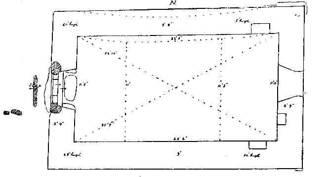
Fig. 2. Scale 1/8in. . — 1 foot. St. Patrick's Chapel., Peel.
long ago removed ; the sill is 4 ft. 8 in. above the level of the floor a1 rl has no slope. At the south of the window is a plain rectangular re :ess at a height from the floor of 38 in., measuring 12 by 14 in. and 1 in. high. At either side of the window, about 6 in. higher than its lintel, the gable is pierced by a rectangular hole 11 in. by 12 in., the to 1s of which are on a line with the spring of the gable. No trace of an altar is now visible, but it appears to have been from this Chapel that the cross-slab came which is described in Manx Crosses No 46, and there surmised to have been an altar slab The north wall has a recess at a height from the floor of 3 ft. 9 in., and at a distance from the east corner of 13 in.; this is 24 in. wide, and a similar one at a height of 23 in. from the floor occupies the like position in the south wall. The walls are of fairly even thickness, about 2 ft. gin. built of stone throughout but in random courses, and from 4 to 5 ft. high except at the east end, the gable of which is still standing, showing the height of the walls to have been originally, about 9 ft. from the floor, the gable standing another 9 ft. The curving of the north wall must be due in part to settlement, but there may have been an intentional slight outward inclination at its north end. No pavement now remains, but the level of the floor is indicated by some projecting stones about the middle of the south wall. It has been rough cast within and without. There is nothing to indicate that the dressed stones at the door are not part of the original structure ; the style of building, the height of the walls and the large size of the door and window, show it to have been an advance upon the type of our early Keeills, with which it otherwise accords in its small size and plain rectangular form.
A building 20 yards N. of the Round Tower, entered on the O.S. IX. 2 (847) as a "Chapel," differs in a marked degree in its orientation, which is to the E.S.E., St. Patrick's Chapel pointing a little N. of E. Though of larger size, the proportions are similar to the last, 28 ft. 9 in. by 14 ft., but what seems to make it doubtful that it was designed for a Church is that the doorway is in the east end, and there is no joint or trace of any kind in the walls to show that there was ever any other entrance. The walls are about 2ft. 6 in. wide, built with great regularity and evenness, of local stone undressed, with some red sandstone and a few quartz boulders ; they stand from 18 in. to 3 ft. high, rising at the east end to 6 ft., but show no trace of a sill or window. The doorway, at 2 ft. from the south wall, measures 3 ft. 3 in. wide inside, narrowing to 3 ft. outside. There is no step or sill, nor any appearance of dressed stone having been used either in the doorway or elsewhere in the building, which otherwise is of the same character as the last.
A number of skeletons are said to have been found lying below the floor, in sand, but no stone grave or coffin appears to have been met with.
ST. PATRICK'S CHURCH, O.S. IX. a (847), is much larger than any we have yet dealt with (except St. Trinian's), and its proportions are different, being those of our early Parish Churches, that is to say, the length three times as great as the breadth. It measures about 57 ft. by 18 ft., and has an orientation slightly north of east, almost the same as that of St. Patrick's Chapel already described. The Cathedral, which is almost certainly of later date, has an orientation as much to the south of east. The doorway is on the north side at a point 6 ft. from the west end ; it is 3 ft. 9in. wide inside ; at a depth of 14 in. it has at either side a square recess, reducing the width to 2 ft. 10 in., from which it expands to 3 ft. outside ; the outer jambs now about 3 ft. high, are plain square blocks of granite ; it is paved with flat stones and pebbles, but shows no step or sill. The east window, from which all the dressed stones have been removed, is 7 ft. 6 in. wide inside and 6 ft. wide outside ; the top of the arch is on a level with the spring of the gable, the sill appears to have been at a height above the floor of 5 ft. but the space below has long since been broken through to convert it into a doorway, being so represented in Robertson's Tour, 1793 [sic Robertson copies his description from Grose which has the figs].
Cumming in his Guide to the Isle of Man, 1861, records that " the windows and doors are circular-headed, the voussoirs being very thin and deep." But, the Manx Society, Vol, XIV, p. xv, — gives a figure taken from a drawing "made in the time of Bishop Wilson." This shows the western bell-turret, north doorway with rounded arch, and near the east end of the north wall, a window which is distinctly flat-headed, as well as a two-light arched window in the east gable. Mr. Anderson, who was in charge of the repairs to the Castle ruins under Governor Loch, reports of this (1877), " the manner in which the east window of St. Patrick's Chapel has been restored is a good example of how the architectural features of a building may be lost or falsified." On the north side of the east window, at 18 in. from it, is a shallow arched recess, 2 ft. wide by about 6 ft. high, and 3 in. deep Above this the gable is recessed about 6 in., no doubt for the sake of lightness to the structure. Unfortunately, all trace of the altar is now lost ; along the south wall there is a slight projection of about 5 in. for a distance from the corner of 5 ft. 6 in. ; this stands 11 in. at its highest point, and may represent the raised dais on which the altar stood. At the east corners of the north and south walls are plain rectangular recesses at a height from the floor of 4 ft , the first 14 in. wide by 17 in. deep, the other 32 in. wide by 16 in. deep. The walls are built in irregular courses of undressed local stone mixed with mortar which we are told by Cumming is " softer than that of the Round Tower "; a large portion of red sandstone of small size is used with the local slate, or rag-stone, and a few granite boulders. Three or four courses, of varying lengths, within and without, are in herring-bone fashion. They have an even thickness of 3 ft. 6 in. and stand in part at their original height of about 13 ft. above the floor, namely, on the north side, from the east end to the doorway, and the middle part of the south side. The western gable was blown down in a gale many years ago, and, in 1877, was " lying on the ground partly covered with soil "; it had a double belfry, remains of which may still be seen ; in its ruins are the very worn remains of a red sandstone Holy Water Stoop. There are no traces of a pavement save the flags in the doorway. The foundations must be on the rock, which, outside the east end, crops out above the surface Cumming records that there was " a partition wall erected in the place of the rood-screen."
Against the south wall, outside, at 23 ft. from the east end, is a rectangular mound of earth and stones, 9 ft. by 4 ft. 6 in. wide and 2 ft. high, with two steps on its east side.
Evidently of a later period than the Keeills with which we have been dealing, and, with its larger size, different proportions, the use of lime cement, and its western belfry, an advance in style, it still shows the plain rectangular form and total absence of any architectural division between nave and chancel.
This Sheading consists of three Parishes, now surveyed, called after their respective Churches — Kirk Marown, Kirk Patrick, and Kirk German, or, as still known to our Manx-speaking people Skeeilley Marooney, Skeeilley Pherick, and Skeeilley Charmane, or Garman. In the first we have, besides the old Parish Church and that of St. Trinian's, both on the sites of earlier buildings, the ruins or the sites of eight Keeills ; in Kirk Patrick we have found eleven ; and in Kirk German, including the three on Peel islet, we have fourteen, besides two instances of lintel graves which seem likely to have been associated with Keeills. Of these, 16 have sufficient remains of foundations remaining from which to make a plan and ascertain their dimensions, but no only eight cases are the walls now over three feet high ; in 16, the foundations of the doorways still remain, but in six only have traces of windows been found. In only one case (except the two at Peel) has any architectural detail been met with, namely, at Lag-ny-Keeillagh, at which a flat-topped window-head of very simple character and rude workmanship was found.
Eight have remains of the altar at the east end, and, in connection with five of them. eight broken cross-slabs have been met with, all of them apparently earlier than the 7th Century. This, of course, does not prove the date of the Keeills, some of which are re-buildings evidently occupying earlier sites. There are differences in the mode of building, in the proportions and in the position of the doorways ; when we shall have gone through the five remaining Sheadings, we shall probably be able to classify them, and may expect to know a little more of their period and of their character. The fact that so few remain and that these are in such a ruined condition should influence all who are interested in the history of our past to preserve them and not only to prevent further destruction, but to see that what remains are kept drcently and in order, free from briars, gorse, and the roots of trees. In only three instances have we been met with a positive refusal to allow any examination to be made. In one the Keeill is kept clear of briars, but as it is entirely concealed beneath the turf, it is impossible to ascertain its features or correct measurement, or even, except from hearsay, to know that it was a Christian Keeill. The other two are overgrown with gorse and briars, the roots of which must rapidly destroy what — if any — still remains of their foundations, while the graveyards formerly attached to them are ploughed over. We fear that the owners and occupiers do not realise that the object we have in view is not to destroy but to preserve their remains, not to bury them out of sight or conceal them as something evil or unclean, but to vlace on record what may still be learned of these, the only material evidence of the introduction into the Island of the Christian religion and of the conditions under which our forefathers were wont to worship.
We must express our thanks to those occupiers and proprietors who have given us permission to examine and search for remains on their lands : — :Messrs. C. Kennaugh, Philip Cannell, the Baume Trustees, J. Corrin, J. Crellin, W. Graham, G. Smith, E. Gell, E. T. Christian, J. Quilliam, J. Corkill, J. Craine, A. Matthews, C. Crellin, and R. Watterson ; and for the information and ready assistance they afforded. Mr. C H. Cowley, who acted as Secretary to the local Committee, with their aid revised our lists examined our maps, and obtained for us the names of Treens and Quarter lands and much other useful information, for which we are obliged.
In Appendix I. we give a list of articles found or heard of in the course of our Survey. Appendix II. gives our Treasurer's Statement and list of subscriptions received. Appendix 11 1. gives the names of members of our Committee.
Read and adopted at a meeting of the Committee held at Kirk Michael, Friday. September 23rd, 1910,
RAGLAN, Chairman.
* These appeared in the Reports sent out to Subscribers of 10'6 a year. and. to those who had given special assistance in the work. and need not be repeated here.
The Statement shows Subscriptions £28 ros. od. but, of this amount £14 was given by Lord Raglan.
The Expenditure including £22 9s od. for printing the First Report, amounted to £31 14s. 2d., and there remained a balance in the Bank of £4 13d. 7d.
There are a few large; paper copies of these Reports in hand which are fully illustrated Application for them should be made to the Hon. Secretary.
|
|
|
|
|
|
||
|
Any comments, errors or omissions
gratefully received MNB
Editor |
||