[From Proc IoMNHAS vol 1]
TO THE ISLE OF MAN NATURAL HISTORY AND ANTIQUARIAN SOCIETY.
First Report of Committee consisting of His Excellency the Lieut.-Governor (chairman), and Messrs P. M. C. Kermode (secretary), J. C. Crellin, J. McMillan, A. Rigby, and T, E. Acheson (treasurer); appointed (with power to add to their number) April, 1908, to make inquiry as to the number and position of all the Historic and Pre-historic Remains in the Isle of Man, to conduct a careful and systematic examination of such remains, and to draw up a full and particular Report thereon.
At a meeting held at Crosby, in Marown, April 16, 1908, it was unanimously resolved
(1), that the Committee should adopt the name and title of " The Manx Archæological Survey."
(2) That the members elected by the Society should form an Executive Council ; and that the Committee should be enlarged by the addition of — 1, The Manx Museum and Ancient Monuments Trustees, as ex-officio members ; 2, Subscribers of not less than ten shillings and sixpence a year, who would be willing to act upon it ; and 3, A representative of each Parish. His Excellency agreed to write to the Captains of Parishes inviting them to assist the work of the Survey in their respective parishes, and to nominate two or more of their parishioners to act with them as sub-committees for the purpose, and to appoint one of them as their representative on this Committee.
(3) The following programme of work was agreed upon : — That the different classes of remains should be taken in order, under the heads of 1, Ancient Keeills or Chapels, and Rhullics or Christian Burial Grounds ; 2, Circles, Cairns, Barrows, or pre-Christian Burials ; 3, Camps, Forts, Earthworks, and pre-historic settlements ; and (subject to be varied from time to time if for any reason considered by the Executive Council to be advisable), to finish with one such class through all the parishes in order before beginning on another.
This programme having been adopted, it was decided to begin with Class 1 as the most recent of the antiquities, and to commence operations in Marown, the central parish of the Island, beginning with the Church or Chapel of S. Trinian's, the existing ruins of which fall within the period of our historic records.
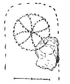
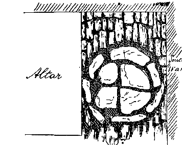
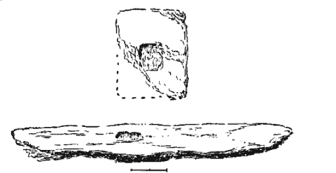
S. TRINIAN's. — Shown on Ordnance Sheet (25 in. scale), X, 13 (enclosure 52,8). It stands on the Barony of S. Trinian's, and the Quarterland of " the Rock," at a height above sea-level of about 175 ft. Mr. Corlett, the proprietor and occupier, shortly after we had begun to examine it, nominated the Museum and Ancient Monuments Trustees as guardians, and they took over the work of examination, and have since expended a large sum of money in protecting and putting the ruins into a good state of repair, as appears in their fourth annual report, published by Messrs. G. & L. Johnson, Douglas." — We may say here that the existing walls, apparently of the XIllth or XIVth Century, which are of unhewn and undressed stone, in irregular courses, are well built with lime cement, the stones fairly large and well-fitting ; a few are placed on end. It is rectangular in plan ; the foundations of a wall show there had been a screen between the chancel and the nave, which are of the same width ; there was no chancel-arch. On the south side of the altar the stones of the pavement take the form of a plain cross within a circle — Fig. I. This in older buildings would mark the spot where the founder's shrine would be placed. The south doorway had been re-constructed from a building of the XIIth Century, to which period belong several dressed stones of Foxdale granite found built into the walls, including a small monolithic arch, capitals, sill-stones, jambs, and others, proving that there was a church on the site certainly in the XIIth Century. The discovery in the chancel of a cross-slab of the V1th or VIIth Century (see Fig. 2), also implies that there had been Christian burials, and, therefore, probably, church buildings on this site at a very early date. The remains, and what may be gleaned of the history of S. Trinian's are of such special interest and importance as to deserve a separate memoir, and this we hope may be undertaken by our members Mr. Rigby and Rev. J. Quine, in the form of papers to the Natural History and Antiquarian Society during the year.
FIG. 1. Pavement Cross, S. Trinian's.
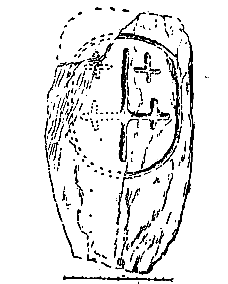
FIG. 2. Cross-Slab, S. Trinians'.
* This and the previous reports of the Museum Trustees (illustrated) may be had from the Publishers for the small sum of sixpence,
Besides the old Parish Church on Ellerslie, formerly Balla-killey, about 330ft. above sea-level, which is probably on the site of more ancient buildings, dating back to the influence in the Isle of Man of the Columban Mission, there are in the parish of Marown, the sites or ruins of eight keeills, namely : —
1. Nameless, on the Quarterland of the Rhyne and Treen of Ballaterson.
2. Keeill Vreeshey, S. Bridget's, on the Quarterland of Balla-yemmey, Treen of Ballayeaman.
3. Keeill Pheric, S. Patrick's, Quarterland of Ballafreer, Treen of Trollaby.
4. Cabbal Druiaght, Quarterland of Glenlough, and Treen of Glenlough.
5. Nameless, on Ballaquirmey-moar, Treen of Sanbrick.
6, Keeill Lingan, Quarterland of Ballacotch, Treen of Sanbrick.
7. Nameless, on the Quarterland of Ballachrink, Treen of Ballanickle.
S. Nameless, on the same Quarterland of Ballachrink, in an enclosure called Bwoaillie Willie, Treen of Ballanickle.
RHYNE. — No traces now remain of the first, the site of which has long been ploughed over. It is marked on the Ordnance Sheet, X, 10, (335), at the height above the sea of 405ft., and is still remembered by people in the district. The O.S. shows the outline of the banks which marked the boundary of the enclosure, and, towards its N. W. end the keeill itself, but the latter is given in dotted lines to signify that no remains of walls were then visible, and the impossible measurements of 50ft. by 20ft. show that it was merely intended to indicate roughly what was believed to have been its original position. A broken slab described in " Manx Crosses," No. III, Pl. IX., bearing on one face the beginning of an inscription in runes, — Thorbjorn raised this Cross . . . , was in 1878 found loose in the stackyard wall of the Rhyne farm by Mr. Jenkinson, author of a Guide to the Isle of Man, and is now in the Insular Museum. The dedication of the keeill is lost, and there is nothing to indicate its period, but the finding of this monument shows that it was still in use for burial so late as the XIIth century. A lintel grave was found when ploughing in 1908.
FIG. 3. — Plan of Keeill Vreeshy, Marown.
(Scale, 1/8in. to the foot)
KEEILL VREESHEY is in a good state of preservation compared with most of these chapels. Its ruins stand about half a mile north of the Crosby Post Office, O. S. , X, 14, (748), at a height above the sea of perhaps 380ft., in an enclosure called " The Chapel Field," which, according to Mr. Paul Bridson (see "Yn Lioar Manninagh," VOL III, p. 433), was in 1861, known as Garey Keeil Vreeshey. The name is now forgotten, but we found one man who had heard that the field was called " the Breesh." The keeill — Plan, Fig . 3, measures 16 ft. by 9 ft. 3 in. at the east end, and 9 ft. 8 ins. at the west.* The doorway at the western end of the south wall is 18 in. wide, splaying outwards to 24 in. at the foundations, — its western side running in a line with the western wall ; the jambs incline to 21 in at a height of about 2 ft. above the floor level, but this may be due in part to settlement ; the sides of the doorway were built up of large stones ; the threshold is crossed by a stone on edge, set in the ground (total height about 12 in.) from which the pavement sloped outwards, and two steps led inwards. Near the eastern end of the south wall is the window, 16 in. from the south-east corner, the sill of which is 3 ft. 4 in. above the floor ; it measures 16 in. wide inside, and has a splay inwards and slightly outwards. On the floor at the east end, a small stone on edge at the north side, and one or two flat stones, indicate the position of the altar, about 4 ft. long by 2 ft. wide. The sill of the east window sloping outwards 1" in 14", which appears to have been about 18 in. wide inside, is 3 ft. 6 in. from the floor ; crossed at 13½ to 15½ in. from the face of the wall, by a vertical slab, about 14 in. high by 12 in. wide, and 2½ in, thick. The opening, no doubt, would be immediately above this. In the middle of the wall, on the floor level, where it would be hidden by the altar, a stone which, unlike all the others, was set on edge, was found to cover a built recess in the wall, 18 in. deep by 16 in. high and 12 in. wide. The walls were built of stone undressed and unhewn, with earth only to fill in the interstices, the foundation stones being fairly large and well-fitted ; the walls are duly tied at the corners. Outside, under the south window, a large granite boulder, 3 ft. 4 in. by 2 ft. 6 in. high, was set on edge, the other stones being laid in rambling courses. All the walls are banked up outside to the height of 2 ft. by earth with some large stones, spreading to 3 ft. and more in width at the base, and having, especially round the doorway and at the west end, stones laid lengthways on the top, radiating from the wall as though to carry off the rain. The inside height of the south wall is now 5 ft. from the foundation (and this perhaps was the full original height), the others being a few inches lower. The floor was rudely paved with stones of irregular size and shape, averaging about 12in. by 9in., and 5 in. thick, — the largest being 17 by 10 by 5 in. The north and west walls had bulged inwards about the middle, as shown by dotted lines on the plan. The enclosure has a south-westerly aspect and is roughly oval, measuring to the outside of its surrounding embankment about 58 ft. east and west, by 40 ft. north and south ; the keeill being at the north-west, and the bank against its northern wall running into that of the enclosure. The ground is artificially raised at the west by about 12 in. to bring it to a level, while at its north-east corner the ground has been slightly excavated for the foundation. The outer embankment is formed of earth with large stones, and is about 4 to 6 ft. wide ; it appears to have extended further at one time, as we were told that lintel graves had been discovered when ploughing immediately outside on the north-east. No entrance was now visible, but the absence of stones on that part opposite the doorway, with remains of pavement reaching about half-way from the door in a line with it, seems to indicate that there was a gate-way at the west end of the south wall. There were slight but certain traces of burial by inhumation against the south wall of the keeill outside the east corner, but neither covering nor side-stones. Inside, three rounded white quartz pebbles were found, and near the altar, a fragment flaked off a cross-slab, 6 in. square, showing remains of a linear cross with expanding ends to the limbs, of the type of the Jurby cross-slab, No, 14 in " Manx Crosses. " — Fig. 4.
* All measurements of buildings, unless otherwise stated, are taken from the inside.
KEEILL PHERICK. — The Ordnance Sheet, XIII, 2, (1333), shows the position of Keeill Pherick on Ballafreer, some 260 ft. above sea level. We were denied permission to examine it by removing the growth and accumulated rubbish, and were, therefore, unable to take accurate measurements, or to ascertain the nature of the building, or whether it had remains of pavement or altar, or traces of any windows. So far as could be judged as it lay hidden under the sod, it appeared to measure about 15 ft. 3 in. by 8 ft. 10 in., and to have the doorway in the west gable. Inside was a large stone with shallow basin, said to be a font.
The keeill is in a small plantation called the " Orchard," a part of the present hedge of which is evidently that of the original embankment of the cemetery. In former times, until about 50 years ago, the vicar of Marown read prayers in the chapel on Ascension day. Vicar Duggan, 1840 to 1862, appears to have been the last to have done so. In connection with it, a story is told of S. Patrick, that when the saint was passing through the field, his foot was torn by a briar, whereupon he declared that the field should never yield fruit to deprive men of their senses ; and for this reason, we were told, it is always kept under pasture. Y. L. M., III, p. 433.
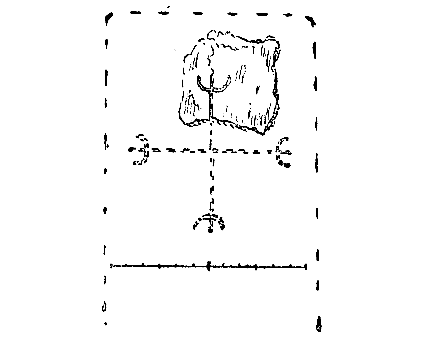
FIG. 4. — Fragment of Cross-slab, Keeill Vreeshy.
CABBAL DRUIAGHT, marked on O.S. X111, a, (1393). The foundations remain in the plantation at the entrance to Glenlough, 205 ft. above the sea. The keeill measures about 13 ft. 6 in. by 8 ft. 6 in. — see Plan, Fig. 5. The doorway is in the middle of the west end, 17 in wide, inside, and apparently about 12 in, outside, with two steps, 9 in. and i t in. high ; the jambs on the south side consisted of two upright stones, at the foundation, and an outer stone laid flat — the middle one is now pushed out of position. A large stone is laid horizontally above the middle upright one, above which no doubt it was built in courses. The inner stone on the north side consists of one end, 11 in. thick, of a very large slab, the middle one has fallen out and the outer one of white quartz, is laid flat. Near the east end of the south wall were found the jambs but not the sill of the window, which must have been about 14 in. wide, at a height from the floor of a little over a ft. ; the western jamb and the outer stone of the eastern jamb, were in position straight through the walls, with inward splay of only two inches ; the stones on which the sill had rested show a slight fall outwards. At the east end the base of the altar still remains, 4 ft. by 2 ft. 6 in., now only about 10 in. high, above the pavement, built of slabs laid on the earth,+ with upright stones forming small pillars at the two fore-corners; these measure respectively 13 in. high by 12 in. wide and 6 in. thick, and 10 in. high by 11 in. wide and 4 in. thick.
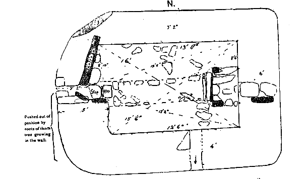
FIG. 5. — Plan of Cabbal Druiaght, Marown.*
(Scale, 1/8in. to the foot).
At the foot of the altar a narrow stone, 33 in. long, forms, together with an inner one set on edge, a sort of step 7 in. wide, and 3 in. above the floor level. Above the altar were indications of a window at about the same level inside as that on the south. Two thin slabs, apparently sill stones, had fallen in owing to the loose sand used for filling in the wall having filtered out, or been excavated, perhaps by rats. Their width, about 18 in., gives an idea of that of the window ; one of the south jambs, at 14 in. from the inner face of the wall, and almost at right angles to it, measured 22 in. long by 9 in. wide and 6 in. thick. The walls, now only from 2 ft. to 3 ft. high inside, are of unhewn stone of varying size and irregular shape, some of the larger being set on end. In the east wall, three foundation stones cross the full length of the gable, which, together with the south-east corner-stone, are of well-fitted blocks of granite, from 18 in. to 36 in. long, and 6 in, to 10 in. high. A single stone, 4 ft. 8 in. long and 8 in. wide, stands on edge and forms the foundation the whole length of the wall from the door to the north-west corner; outside of this, another, as large, crosses the outer corner of the building. The walls were surrounded by an artificial bank about 3 ft wide at the base. The whole of the south-west corner has been pushed forward by a thorn tree growing in the wall. The floor, which has a slight fall towards the west end, was paved with small roughly laid stones, the middle part raised 3½ to 5 in. above the rest, forming a path or aisle about 26 in. wide from the door to the altar.
The enclosure, with southern aspect, is roughly circular and about 27 yards in diameter, the keeill placed towards the north-east ; it is artificially raised to a level and surrounded by remains of a bank of earth strengthened with stones, about 8ft. to 10ft. wide. A few years ago lintel graves were found in the avenue, about 15 yards from the north-west inner corner of the keeill, showing that the cemetery had been larger. Traces of burial were met with inside the keeill near the east end, but no lintels. A number of small round white quartz pebbles were found, some in the pavement ; 81 packed in the east gable must have been dropped there since the sills had fallen in ; altogether about 230 were met with.
+Probing with an iron rod, gave no indication of stones, nor of a recess, beneath the altar,
* The owner, Mr. Cadman, has now placed this under the guardianship of the Manx Museum and Ancien Monuments Trustees.
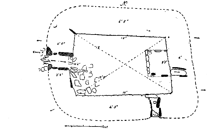
FIG. 6. — Keeill at Ballaquinney, Marown.
BALLAQUINNEY. — These remains, marked on O.S. XIII, 2, (1473), stand in a plantation of larch known as the "Faerie Orchard," at a height above the sea of about 195 ft. The Keeill — Plan, Fig 6, measures about 16 ft. by 10 ft. 6 in,; not only is it not rectangular in plan, but the lines of the walls are irregular, though this may be due in part to settlement. The embankment aganist them can only be faintly traced for about two feet at the east and west ends. The doorway is at the west end ; the jambs, so far as they now remain, are upright stones, three on each side (one which had fallen in was set up by us); it is 15 in, wide, and splays inwards to 24 in. ; as usual there is a slight inclination of the jambs. No step was found but there was a slope rising to 10 in. at a point 27 in, from the inner face of the wall, from which to a point 15 in. further out it falls 5½in.
Traces of the south window remain, but the sill and some of the jamb-stones are gone ; it is now 18 in. above the floor at its east corner and 22 in. at its west; the sill-stone would be probably about 3 in, thick ; it has a slight outward fall, and appears to have measured about 20 in. wide inside, narrowing at 28 in. back to a width of 9 in., from which point it splayed outwards to 17 in., the thickness of the wall being here 3 ft. 6 in. The base of the altar remains at the east end, 4 ft. 6 in. by 3 ft. 6 in. on north, to 3 ft 11in, on south, and now about 7 or 8 in. above the pavement, which slopes upwards considerably ; it is composed of small flat stones laid on the earth (with no Gist or recess beneath it), having at the fore-corners two upright pillars ; that on the north was missing, but the hole where it had been inserted remained, that on the south, a smoothly rounded slate stone, was 25 in, high by 11 in wide and 3½ in thick. The outline of the altar was marked by small stones on edge, from 5 to 6 in. above the floor, 6 in. wide in front, 3 to 3½ in. at the sides ; these passed round outside the pillar on the north side, and formed a sort of step in front — taking the place of the long slab sometimes met with in this position. Of the east window there remained the sill-stone, 29 in. long by 13 in. wide and 13/4 in. thick at a height above the floor of 30 in. At a point 3 ft. 6 in. from the south corner, one of the inner jamb-stones was in position at right angles to the face of the wall, and measured 11 in. by 5 by 1½ in. The window would appear to have been about 18 in. inside (the wall here being 4 ft. thick), and, like the south window, it narrowed at a point 28 in from the face, to a width of 12 in., having an outward fall (in this depth) of 7½ in. Whilst in a line with the doorway, it is curiously out of the centre of the gable. The other jamb, at 5 ft. from the north corner, is 27 in. long by 10 in. high and 1½ in. thick. A hole behind the altar, passing diagonally upwards through the wall, appeared to have been caused by excavation or loss of the sand with which the wall was packed. The walls were found to be faced inside with undressed stones built in random rubble into a surrounding bank of earth — the middle, about 20 in., filled in with loose sand, together with which they formed a thickness of 4 to 5 ft., having now an average height inside of 3 ft. Two large stones were set on edge. The floor, with a rather abrupt fall from the east end for about half way, and then more gradually to the west end, was paved with small stones, from 12 in. by 9 by 3I2 to 7 bv 4 by 2 in., their surface being at a level of about to in. above that of the foundations.
The enclosure of all irregular oval shape, has a north-easterly aspect, and measures to the outside of the surrounding embankment about 43 yards north and south by 53 yards east and west. It is artificially raised to a level about 2 ft. at the east gable, and 3 to 4 ft. at the north-east end ; the embankment of earth strengthened with stones, now measures 5 ft. 6 in. high outside at the east end, with an outer ditch, thus forming a Rath or Lis, its diameter agreeing very closely with the measurement said to have been adopted by Patrick in all such works, i. e., 140 ft, A little stream, evidently diverted in recent times, now runs at the north side ; it arises from a spring in the field' above, and the contour in the ground shows how it must originally have come down the middle of the plantation to about the centre of the western embankment, where it divided to flow all round it. Some semi-circular hollows, marked out by stone, against the inner face of the embankment, seem to mark the position of cells or small enclosures, and the whole bears the appearance of a small fortified position. Traces of burial were met with across the outside of the doorway of the keeill 12 in. below the surface, but there were no lintel stones. South of the keeill, opposite the west jamb of the south window, and at a distance of 9ft. and of 12ft., two small lintel graves were found, about aft. by 9in. by 7in., at a depth below the surface of 18 in. About 150 white quartz pebbles, from one to three inches diameter, were found scattered throughout the floor, several being in the altar. A flat, triangular, holed stone, of local rock, 4 1/8 in. by 2 7/8 in. and 1/8 in. thick, was found, together with a finely-polished, red-coloured, flint strike — a-light, triangular in outline, 2 7/8 in. by 2 in. and ½in. thick. Built into the altar were broken fragments of two cross-slabs of garnetiferous schist of the neighbourhood — Figs. 7 and 8 ; one shows on one face remains of one arm and circle of an outline cross surrounded by a circle of 6 in. radius ; the type is that of Nos. 25, 26, in " Manx Crosses"; the original size of the slab must have been about 36 in. by 22 in. by ½in. thick. The other stone, in four pieces, of similar material, appears to have measured originally about 24 in. by 12in. by ½ in. thick. Two pieces which fit together, show on one face a cross and surrounding circle, with radius of 4½ in. of similar type to the last. Near by was found a fragment of the upper stone of a granite quern ; the radius appears to have been about 7 in., making a diameter of 14 in. or thereabout.
|
FIG. 7. |
FIG. 8. |
|
Cross-slabs, Ballaquinney, Marown. |
|
KEEILL LINGAN is marked on O.S. XIII, 6 (1842), and stands in an almost rectangular enclosure planted with larch and firs, at a height above the sea of about 295 ft.; the north wall is out of line at the east end, and the corner rounded, The usual bank outside can be traced for about three feet from the walls, but very faintly.
The Keeill measures about 13 ft. by 9 ft. 6 in. The doorway is curiously placed at the east end of the south wall, and is 21 in. wide inside, and 19 in. outside. The jambs are, at the foundation, upright stones inclining ; that on the west being at an acute angle with the inner face of the wall, thus widening the space at a point 15 in. from the face to 25 in.; the threshold is crossed by a step about 9in. high. No trace of an altar was found, nor of a paved floor. The walls inside are faced with unhewn stone in random courses, against a bank of earth with stones, the foundations being considerably lower towards the east end owing to the falling surface of the ground. Their present height is about 4 ft. from the floor inside ; many of the stones being laid endways (some are 2ft. long) look small, and give a very rough face to the wall. Some are of fairly large size, however, and, round the south and west walls, all the lower stones are set on edge, measuring from 16 in. long and 22 in. high to, in the case of one at the west end, 5ft. 6in. long and 21 in. high. A loose fragment of a slab which is pierced might have been broken off a door-lintel.
The enclosure, about 90 ft. north and south by 70 ft. east and west, has a north-easterly aspect, the ground falling towards a small stream, and is artificially raised to a level ; the embankment is formed of earth and stones. Immediately below the foundations inside the keeill at the east gable were some heavy slabs which at first were taken to be part of a pavement, but, on raising them, they were found to be graves which had been crushed and had fallen in ; some brick-red clay was met with, but if it had been pottery it was now crushed out of shape and dissolved by the wet ; at the north-west corner an area of about 5ft. by 3ft. was occupied by similar graves with heavy capstones, one of which passed partly below the foundations of the corner, outside of which were more ; these contained charcoal and fragments which certainly belonged to cinerary urns ; some apparently crushed pottery with ashes was met with also at the south-west corner. Altogether it was evident that this had been a cemetery of the Bronze age before it was converted to Christian uses. Within the keeill lies a stone with a rectangular hollow on one face, measuring 26 in. long by 12 in, wide and about 8 in. deep, the hollow 20 in. by 7 in. by 1½ deep, the edges of which are practically vertical, tapers to nothing at one end. This has been called a font, but call hardly be meant for one. Six small pebbles of quartz and flint were found in the keeill, and at the east end a holed stone, triangular in section, perhaps a cresset, 6½ in. long by 4 by 3½ in., with a cup-hollow a in. diameter, and an inch deep.
BALLACHRINK. — O.S. XIII, 5 (1663), marked " Site of Chapel and Burial Ground" in the corner of a field a little north of the farm house, called the "Chapel Field," 500 ft. above sea-level, where there still remains an uncultivated spot about 100 ft. east and west by 75 ft. north and south. Some stones and a slight mound seemed to indicate the position of the keeill, and, upon digging, we came upon the site about the middle of the south side of the present uncultivated plot, and 45 ft. east of the corner of one fence by 39 ft, west from another, and 54 ft. south of one running northwards. Almost all the stones of the walls had been removed, so that it was impossible to make a plan of the building or ascertain the dimensions with certainty. We found, however, the pavement of the doorway at the west end, 18 in. wide; a large stone on edge, about 13 in. south of this, seemed to have been part of the wall and possibly marked the south-west corner. Parts of the banks which had surrounded the walls remained, by which it would appear to have measured rather less than 21 ft. by 13 ft. outside, and so could scarcely have been more than 15 ft. by 7 ft. inside at most. A field wall to the south-east evidently contained many of the stones from the keeill, which were of the usual character, unhewn and undressed No lintel and no appearance of carving was discovered.
The enclosure with southern aspect had been larger, as lintel graves had been met with in the adjoining field about 60 ft. to the south-east; probably it had extended somewhat on the south also. The old road from S. Mark's had passed by the keeill before the present highroad was formed. Near the west end the broken top of a socket-stone was found 5½ by 4½in., flaked off to a thickness of 1½in.; the hole was i%, in. diameter to a depth of 1¼in., the stone was a boulder of reddish fine-grained granite. About 13 quartz, and a flint pebble were found.
Against the east bank was a large slab of clay-slate, 4 ft. by 3ft., with a natural slope from all sides towards the centre, and there pierced by a hole 4 in. diameter ; this was found to lie over a recess (not lined with stone) in which was some very fine soil with ashes and apparent traces of burial. At its north-west end were small stones set on edge, while adjoining it, on the south, were six small paving-stones which seem calculated to have formed with it the base of an altar ; on the south side of our excavations was a small well-formed cist, and, at the north-east and north-west, cists with ashes and clay, apparently crushed and dissolved pottery, similar to the worst preserved of that met with at Ballingan. Altogether, it appeared certain that in this instance, as at Ballingan, a keeill, with its Christian cemetery, had been erected on the site of an ancient Bronze age burial place.
BALLACHRINK, NO. 2. This is marked on the O. S. XIII, 5, (1783), as "Site of Chapel and Burial Ground," and occupies a corner of a small field known as the "Chapel Field," in an extension southwards of the Ballachrink between the estates of Ballanicholas and Ballacallin. It stands 400 ft. above sea-level, and has a south-easterly aspect.
As we did not get leave to excavate, we were only able to look at the remains as they lay concealed beneath the growth of grass, ferns, and briars. The outline of a rectangular building could be discerned, measuring apparently 10 ft. by 6 ft., and the doorway seemed to be at the west end. The surrounding enclosure has been ploughed over, but at the time of the Ordnance Survey, about 1868, there was an uncultivated space of about 6o ft. north-east and south-west, by 30 ft. south-east and north-west, but the foundations themselves are not shown.
This site and the last were visited by an excursion of the Society in July 1899, Y.L.M., iii., 502.
The best preserved of these remains in Patrick is that at Lag-ny-Keeilley, at the foot of Cronk-ny-Irree-laa, which fortunately we were able to examine carefully and fully. So far as we can learn, the following is a complete list of the Keeills in this parish :
1. Site of Keeill Crore, about 164 yards south-east of the Parish Church, on the Quarterland of Knockaloe, Treen of Gordon,
2. Site of Keeill on Ballabrooie, Treen name lost; Bishop's Barony,
3. Site of Keeill on Gordon, Treen of Gordon,
4 Site of Keeill on Rhaby, Treen of Rhaby,
5 Site of Keeill at Crosh Pharlane, on Ballachrink, Barony of Bangor and Sabal,
6. Keeill Woirrey, Kerroodhoo, Glenneedle, Treen of Arnicarnigan,
7 Site of Keeill yn Chiarn on Ballelby, Barony of Bangor and Sabal,
8. Keeill Woirrey, Ballachrink, Glen Mooar, Barony of Bangor and Sabal,
9. Site of Keeill on Ballameanagh (near Foxdale), Treen of Arnicarnigan,
10. Keeill at Lag-ny-Keeilley, Cronk-ny-Irree-laa (intack), Erman mooar.
11. Besides these, Oswald, Manx Society, V., 79, records from notes by the Rev. A. Holmes, Vicar of Kirk Patrick, "At Ballabig there was a chapel called Keeill Vout, the walls of which are now (1860) scarcely visible." The name is perhaps a misprint for Ballahig, Treen of Ballabeg, at the boundary of the Parish with that of German.
KEEILL CRORE. — O.S. IX, 10, (67). Nothing now remains of this ; the site, a little triangular plot below the road by the side of the stream called Glion Keeill Crore, is still known as the " Glebe field "; the highroad crossing the stream by the bridge called Droghad Keeill Crore. It stands 100 ft. above sea level, and has an easterly aspect.
BALLAQUAYLE. — O.S. IX, 2, (528). This keeill occupied a commanding position at the head of a steep little glen, some 400 ft, above sea level, looking northwards. We have not yet excavated, but have permission to do so, and are in hopes of finding suffiicient of the foundations below the sod to enable us to make a plan of it. Dr. Oswald records " a few graves visible," (1860).
The GORDON KEEILL is ploughed over, O.S. IX, 14. The site we are informed was near the farm buildings by the stream below the road, which would be about 160 ft. above the sea. Vicar Holmes records " in the burial ground adjoining are to be seen a few graves." Manx Society, Vol. V, p. 79.
RHABY. — O.S. IX, 13, (638), is a place of great interest, and though the walls of the keeill are now gone (some of the stones being built into a fence of the field to the south-east of it), its measurements are recorded by the Archaeological Commissioners in their Report, 1876, as 17 ft. by 9 ft. 6 in. (interior), the doorway, we were told by Mr. Quirk, was on the west.
The enclosure at a height of some 300 ft. above the sea has a westerly aspect, and rneasuras (to the outside of the embankment) about 43 yards from north to south by 18 yards from east to west, and is artificially raised to a level and protected by a strong embankment. The late Mr. Quirk found nine lintel graves in the cemetery. The keeill was at the north-east, its eastern wall against the inner foot of the embankment. Mr. Quirk has given its permission to examine these remains, an account of which we hope to to include in our next Report.
CROSH PHARLANE is still remembered by that name in the neighbourhood. Its site, 300 ft. above sea-level, O.S. IX, 13, (704), can be identified by the discovery even in recent times of lintel graves turned up by the plough, just inside the gate at the south-west corner of the field leading to the farm-house. We have been unable to learn any other particulars of it. Mr. Holmes, not recognising the name, gave it evidently from pronunciation, as " Va Lhane."
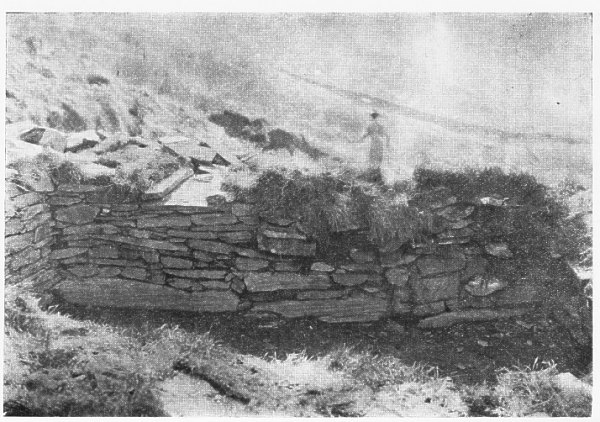
Of KEEILLWOIRREY, Kerroodhoo, O.S. XII, 3, (257), about 500 ft. above the sea, the north wall remains, or what is thought to be so, as part of the wall of the haggart, measuring about 18ft. long, 5 ft. 6 in. high, and 2 ft. 6 in. wide ; it is built of small slaty, stones of the neighbourhood, unhewn and undressed, with earth only in the interstices, and includes some boulders of quartz. Lintel graves were exposed some years ago when the road to the house was lowered at the gate. Mr. Holmes (1860) says the walls at the east end were four feet high, and that the burial ground, about an acre in extent, was covered with stone coffins. Manx Soc. V, 79. A granite font, 17 to 18 in, diameter and 5 in. deep, is lying by the little stream which passes by the other side of the road — perhaps the old boundary line of the enclosing cemetery, and should be preserved.
The Keeill at BALLELBY, O.S. XII, 1, (1905), has long been ploughed over ; a portion of the wall of the enclosure is preserved in that of the old road by the side of which it stood, some 200 ft. above sea level, with a north-west aspect. The field is known as (Margher) Keeillngh-ny-Chiarn (the field) of the Keeill of the Lord. A fine cross-slab was found here, No. 24 in " Manx Crosses," and now stands by the barn at the entrance to Ballelby.
KEEILL WOIRREY, near Glen Meaye, O.S., XII, 2, (2278), was last winter opened by the proprietor, Mr. W. Quayle, M.H.K., who has kindly given permission for its more complete examination, the result of which we hope to include in our next report. The doorway is in the middle of the west wall. A built recess, lined with small flat stones, was found at the east end, by which one of the pillar-stones of the altar was still standing. No trace now remained of the surrounding enclosure which had been ploughed over. It stands about 350 ft. above the sea, and has an easterly aspect.
BALLAMEANACH. near Foxdale. — The site is not marked on the O.S., XII, 4, but should be on (2995), about 500 ft. above sea-level. Some memory of it still survives in the district, otherwise we have no particulars beyond Vicar Holmes' statement that " there are the walls of a chapel two feet high ; in the burial ground adjoining there was a perfect skeleton found in a stone coffin, about forty years ago," (i.e. 1820). Manx Soc., Vol. V., p. 79.
BALLAHIG, near S. John's. — The site. is not recorded on the O. S., IX, 16, but this is probably intended by Oswald, Manx Soc., V, p. 79. " At Ballabig there was a chapel called Keeill-Vout, the walls of which are now scarcely visible." In the neighbourhood is still remembered a saying by the Caiilagh ny Ghueshag, " old woman of the spells,"
Tra Vees Cabal-keeill- lout ersooyl lesh-y-hooilley,
Cha bee clein Quirk Slieu Whallian veg sodj-ey.
i.e. When the Chapel Keeill-Vout shall be taken away by the flood, the Quirk family will be no longer in Slieau Whallian. (The Folk-lore of the Isle of Man, by A. W. Moore, p. 89).
LAG-NY-KEEILLEY. O.S. XII, 13 (3663). — This most interesting of our ancient keeills, set on a ledge forming a small natural platform near the foot of a lag or hollow torn out of the almost perpendicular western face of Cronk- ny-Irree-laa, can be reached by boat, but the landing — a mile and three-quarters south of Dalby beach — can only be effected within about an hour of high water on a calm day, and the upward climb of about 200 ft. is steep and not easy. The proper mode of access is by the old pack-horse road through Eary Cushlin, which passes onto the Sloc by foot tracks, and so to the south of the Island. This roadway in itself is of great interest as the best existing survival of our pack-horse ways before the modern system of highroads, and a walk along it, — about three-quarters of a mile from the farmstead, — calls up a picture of the condition of our Island in the centuries long ago. The latest funeral to pass this way appears to have been little over a century ago, as it was remembered by an aged parishioner born and brought up at Eary Cushlin, who went to her rest some forty years ago at the venerable age of ninety. The body, wrapped in a winding-sheet, was strapped on the back of the old mare, supported by the " burliagh" or bundle of straw which served for a saddle, and the horse was led down the long track to the little Burial ground surrounding the ruined keeill. The name and dedication are now lost, and that of "S. Lukes," (? Leoc's), given by Oliver, Manx Society, Vol. XV, p. 89, is evidently a misapplication. He adds " in a bull of Pope Eugenius III. the monastery of S. Leoc &c.; " but this quotation refers to Rushen Abbey.
The inner face of the wall at the east end of the keeill was found to have fallen in, but when the loose stones were cleared, the two lower courses as well as the outside of the wall (for a height of over two feet) remained in position ; it was therefore refaced with the stones which had fallen, the other walls being cleared, but otherwise left exactly as they were found. Beneath these fallen stones was discovered the base of the altar. The keeill measures 13 ft. by about 8 to 8ft. 6in. At a point aft. 6in. from the west end both walls incline inwards, narrowing the space between them to 8ft. 2in., but this may perhaps be due to settlement, a projecting stone here in the south wall, making allowance for bulging, appears to be intentional, forming a sort of bracket. The doorway is in the middle of the west wall ; on each side of it the inner stone, about 2 ft. high from the floor, stands on edge, the others being laid horizontally ; there is a slight inclination and a splay outwards from 21 in. to 24 in, For the first time an indication was found of the door itself in the form of a socket-stone (that at Ballachrink had not then come to light), which was in position just inside the doorway on its southern side. This is of silurian sandstone, 5 in. high by 7 in. across the base ; the back and base are flat, the rest roughly rounded ; the hole for the heel of the door is 1 ½ in. diam. by an inch deep. A heavy slab lying close by, which had a hole countersunk through one side, was evidently a lintel, as it was found by measurement that if built with each end set 18 in. into the wall at either side of the doorway, and projecting 3 in. inwards, this hole would be exactly over that of the socket. It was 2 ft. wide and had a natural curve, so that when in position the centre would be slightly higher than the sides. Near the east end of the south wall the sill of the window is found in position at a height from the floor of 3 ft.; the two loose jamb-stones had slipped out so that the amount of splay could not be determined, but the width was probably less than that of the sill-stones, three in number, on which the jambs had rested, making it about 14 in. inside. On removing the fallen rubbish at the east end, the altar, 3 ft. 5 in. by 2ft. 3in. broad, and now 12 in. at the highest point, was discovered, built of small slabs laid length ways. A narrow stone in front, 3ft, 4in long by 5in. wide, served as a step. A curiously elongated pear-shaped stone, 21 in. long by 3 to 8 in. wide, evidently brought up from the beach below and found lying outside the east gable, appeared to have been one of the altar pillars, and was accordingly placed in the keeill. Above, at a height from the floor of 30 to 36 in., was the sill of the east window ; the jambs were gone. A vertical slab, about 14 in. square, crossed the opening at about midway through the wall, the space inside being occupied by two fine slabs, one about 3 in, higher than the other and slightly over lapping it. These sill-stones sloped inwards at an angle, and as it was not certain whether this was their original position, or caused wholly or in part by the slipping forward of the face of the wail, they were left as found, It was discovered that the lower one bore incised crosses, and as some time after this, Mr. Irvine found that it was likely to be tampered with and injured, he carried it up to his house, and has since presented it to the Insular Museum,
The mode of building the keeill was evident ; an excavation had been made in the slope of the hill and the side walls faced with unhewn stones set in the banks, but the excavation had been carried sufficiently far to enable the builder to work at the east end from the outside as well as the inside. Most of the stones appear to have been picked off the face of the hill, but several had evidently been brought up from the beach. They were of fairly even size, built in random courses, their ends for the most part to the face of the wall, making them look smaller than what they really were ; those at the foundation were large and well fitted, the length of the north wall being occupied by four, and of the south, by three stones. A few of the paving-stones of the floor remained in position, of small size and irregular shape.
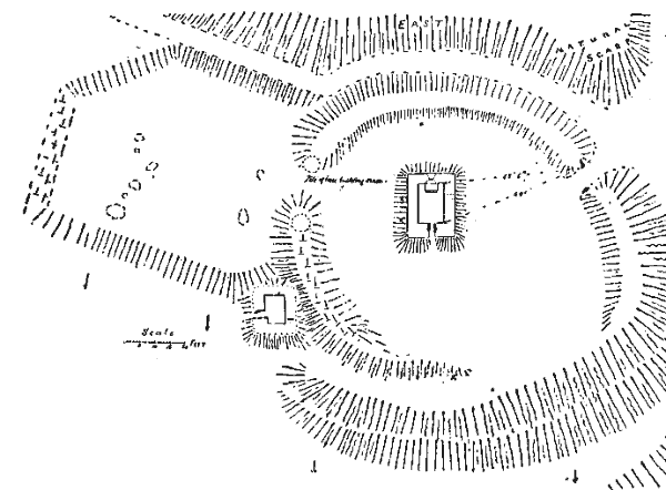
FIG. 9. — Lag-ny-Keeilley. Keeill, Cemetery, Culdee's Cell, and Enclosure
The Enclosure — Plan, Fig. 9, with westerly aspect, forms an oval, about 27 yards east and west, by 33 yards north and south. the keeill being towards the north-east. It is artificially levelled at a cost of great labour by excavating towards the east and filling in towards the west, and was carefully drained with large stones. On the east side the high ground had been cut into, and a bank about 14 ft. wide, left by the approach way made at the back of it (east), which is four to five yards wide ; from this high ground an artificial embankment has been carried about two-thirds of the distance round the northern end, and a quarter of the way round the southern, the west has been filled in by all this excavated soil and rubble and carefully built up, particularly at the south-west, with great blocks of stone from the face of the cliff. The entrance on the south-east is marked by a large upright stone, 4 ft. 4in above the ground by 2 ft. 5 in. at the base, and 7 in. thick ; this would no doubt be used as a bridle-stone at times of funerals ; it serves also as a landmark.
There were lintel graves along the north wall of the keeill, on the outside, and at the east end. Several rounded quartz pebbles at the foot of the east bank also may have been placed there in connection with a burial ; a grave was found in examining what appeared to be a drain at the junction of the small outer platform with the inner one, and one or two more north of the keeill. We set upright stones at the head of these to mark them. About 500 rounded quartz pebbles were met with, a few in the graves at the north side, but most within the Keeill, about the altar. Dr. Oswald, in Manx Society, Vol V., p. 79, says this keeill was examined by Dr. Simpson and others in August, 1849. As they only give the measurement as 12 ft., and make no mention of the altar, their examination would appear to have been superficial, and their statement that " the floor was paved with smooth rounded pebbles," probably merely a surmise to account for the number they saw, though, as the number is unusually large, it is possible that some may have been so used, as well as the ordinary small paving stones. Some remains of the original pavement is still to be seen in position, and is of precisely similar character to that met with in our other keeills, consisting of small, more or less flat stones, irregularly laid on the earth. Near the altar we found a saddle-shaped rectangular slab of local slate, 12in. by 10in. and 2in. thick, having at one corner a cup-hollow, 2 in. diameter by 3/4in. deep, probably a cresset-stone. Outside the wall was the head of the east window, cut out of a flat sub-triangular boulder of grit or Silurian sandstone, which showed this window to have been flat topped, with an opening of 6 in., expanding downwards. Special interest hes in the fact that it shows a rude attempt at moulding, from ¼ to ½ in. in relief — Fig. 10, The sill-stone referred to has on each face a linear cross, approximately equal-limbed, and, at the side of one of these, two small crosses of a form new to the Isle of Man, having two bars, and being set on triangular pedestals. The ends of the lines are drilled — Fig. 11. Besides this, three more cross-slabs were found close by the keeill : one by Mrs. Taggart, in 1907, now in the Museum — Fig. 12 ; and another very similar to it but rather larger, with a much-worn Latin cross chiselled out on each face — Fig. 13 ; and yet another with an outline cross of Latin form — Fig, 14. Outside the east end was found a rectangular slab 27 in. by 22½ by 2 to 2½ in. thick, in the middle of which had been chiselled a rectangular hollow 8½ by 7½ and an inch deep ; one corner is broken off. What this could have been intended for we cannot surmise. Fig. 17. Not far off was a narrow slab 7 ft. 10 in. by 10 in. by 3, with an oval hollow — Fig. 18, also carefully chiselled. Could it have been a lintel or a sill-stone with the hollow made to receive an upright post?
FIG. 10. — Head of Window Lag-ny-Keeilley.
FIG. 11. — Cross-Slab.
FIG. 12. — Cross-Slab, Lag-ny-Keeilley.
Dr. Oliver in describing this keeill, Manx Society, Vol. XV, p. 90, referred to an outer enclosure on the north side which he supposed to have been the cemetery. This did not seem very likely, and we had it tested by trenching in half a dozen places, when we could discover no indication of burial. It measures about 20 yards square, the east side slightly excavated into the slope of the hill ; on the north it is protected by a low wall, from the end of which its level surface stands above the sloping ground, and, round this corner and along the western face, it has been artificially raised and banked up with great stones ; on the south it is bounded by the embankment of the cemetery, into which there appears to have been an entrance-way. It was in fact a carefully formed, drained, and protected area ; it certainly was not bi-sected "by a pathway fringed with boulder-quartz," as described by him and figured in his fanciful plan. At its south-west corner, nestling under the bank of the cemetery, which at this point is now 5 ft. high, we found an appearance of building, and upon excavation this was seen to consist of the foundations of a rectangular structure, 9 ft. from east to west ; 5 ft. 6 in. across the west wall, expanding to 6 ft. 6 in. across the east (internal measurements). The doorway, 20 in. wide. inside, was near the west end of the north wall, and formed a passage over 4 ft. long, the eastern side of which curved inwards, narrowing the entrance to 16 in., and forming a further protection from storms. A stone on edge, which is built across the western end of the south wall, may indicate a window. Four or five paving-stones remained, averaging 12 in. square. The nature of the building was precisely similar to that of the keeill, with which it was almost certainly contemporary, and, we may suppose it to have been the cell, or dwelling of the Priest, perhaps a Culdee, who performed the services here a thousand years ago or more.* A plain granite quern of which a piece, the original diameter of which must have been about 24 in.,was found by the keeill, may have been used by him in the preparation of his food. Of the furnishing of his Church and the nature of his services we can at present only conjecture from what is known of the same period in the surrounding Isles.
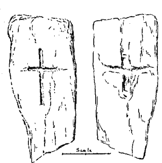
FIG. 13. — Cross-Slab.
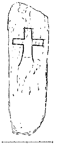
FIG. 14. — Cross-Slab. Lag-ny-Keeilley.
15. — South Wall, Lag-ny-KeeiIley, from inside, showing position of Window, and the nature of the Building.
Photo by Mr. T. H, Midwood. April 7, 1909
Near the end of the pack-horse road, just before coming in sight of the keeill, is a well, known as Chibbyr ny Vashtey, Well of Baptism. It is still regarded as a healing well, in one case water having been taken from it by a person still living whose brother had consumption.
The above is a record of our work for the past year. If funds had permitted, we should have engaged more labour and done more ; it would be more interesting if we could work more quickly, and, in the end, more economical.
"So, the position of Columbas House at Kells (807 A. D.), was "immediately outside the boundary wall of the Cemetery on the north side," Petrie, Eccl. Aarchitecture of Ireland, p. 431.
We are indebted to one of our members, Mr. R. Lace, for the careful examination, free of all expense to the Committee, of a most interesting Keeill at Sulbrick, Santon; but for the sake of regularity, and for greater convenience in the future of making reference to our reports, we hold over the description of this till we come to deal with the Parish of Santon. The Rev. Canon Kewley also aided our work by examining some cists and pottery of the Bronze Age, discovered, when ploughing, by the owner, Mr. J. G. Moore, at Ballacross, Arbcry. This we have noted, and shall refer to when we come to treat of our pre-Christian burials. In the Parish of Maughold, also, the Rev, S. N. Harrison has examined a cairn, or barrow, which he described at a recent meeting of the Natural History and Antiquarian Society. So far as the official work of the Committee is concerned we think it very important that we should adhere to our programme as stated at the beginning of our Report, and when, in case of immediate danger of destruction or injury to a monument, we take the exam-nation of it out. of due course, we think it will be to the convenience of those who may read or refer to our Reports when published that they shall not be fully described by us out of their proper order.
We must express our thanks to those proprietors and occupiers who have given us permission to examine remains on their lands, and to carry out our programme so far : — Messrs. W. C. Corlett, W. K. Kermode, P. Cadman, J. J. Karran, W. Quayle, R. B. Quirk, and D. M. Irvine.
The Captains of the Parishes, in compliance with his Excellency the Governor's invitation, have formed sub-committees, from which we hope for great assistance. To each of them we have sent, or are sending a copy of the " List of Antiquities for the Isle of Man," submitted by Mr. P. M. C. Kermode to the Natural History and Antiquarian Society in 1894. The Committee for Michael, in particular, has been well organised, and has made a preliminary inspection of their whole district, while their Secretary, Mr. J. R. Quayle, has sent in a report, illustrated by numerous photographs taken by him, with a careful revision of the list, so far as it relates to Michael Parish ; this will prove most helpful to us when we come to work in that district, and we hope the other sub committees will work on similar lines. We greatly regret the loss of the Michael representative in the death of Mr. T. M. Mylchreest, who had taken an active interest in the work. We only wish that our means would allow us to proceed more quickly ; had we been able to go through all the parishes with our first class of Historic and Antiquarian Remains in one year, or in two, we might expect a much more general interest to have been aroused, and, with a clearer knowledge of our aims and objects, more hearty support to have been given.
In Appendix I., we give a complete list of the articles found in the course of our survey ; if they continue to be met with at the same rate, it will be seen that it will be a great gain to our Insular Museum, in which we hope they will all eventually find a place.
Of Cross-slabs alone, no fewer than eight very early pieces have been met with in the two parishes yet examined, casts of which are now added to our fine collection at Castle Rushen. Appendix II gives our Treasurer's Statements and List of Subscriptions received, showing that the work so far has been done for the small cost of about £10, exclusive of the cost of Ordnance Maps, which we ask may be defrayed by the Society, since it will have the permanent use and benefit of them. Appendix III gives a List of the Members of our Committee.
Read and adopted at a Meeting of the Committee held in Douglas, Friday, May 7th, 1909. RAGLAN, Chairman.
ARTICLES FOUND IN THE COURSE OF THE EXCAVATIONS MADE IN 1908
('Those marked with an asterisk are now placed in the Museum).
MAROWN.
S. TRINIAN'S.
I. Holy Water Stoup of a hard, dark, trap rock, (actinolyte, which is found in situ at Cooil Ingil), 17in. by 4in., broken across one end. Basin, 7½in. by 2¾in.
2, 3, 4. Three blocks of granite (from corner of doorway or window) (I) 15½in. high, triangular in section, 9in. across the base, by 12in. deep, with apex formed into a plain rounded moulding (by lines cut yin. deep) having a diam. of 47/8in. (2) 15in. high, 9 in, across base, 13in. deep, of similar form.
(3) 13in. high, 7in. across the widest part, and 11½in. deep. The two faces are dressed, showing them to have been corner stones. The lines are chiselled ½ in. deep.
5. Granite capital, 7 in. high, 12in. long by 9½in. broad. With plain chamfer below, tin. deep, on the face and one side,
6, Granite capital, 10½in, high, 8in, long and 13½in. deep. The face carved with a row of four flat pellets (each 1½in, diam., in a hollow grooving, below which it is cut into two small half-columns 4, and 3in. diam. The horizontal groove is carried round one side by a line 4in. long.
7. Granite block 8¾ in. long by about 3in. thick worked to a slight curve along its length, the under edge chamfered — evidently part of the head of an arch.
8. Block, 9 to 13in. deep, having a dressed face 84in. long, expanding upwards to 10¼, and 6in. wide ; cut to a curve with radius 5/8in., the under surface dressed,
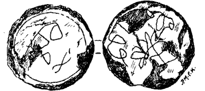
Fig. 16. — Stone Disc, S. Trinian's.
9. Top of window, broken, 9in, high by 10in. diam. at bottom, and 4½ to 6in. deep, The face dressed and shaped to a curve. Below, it is cut to an arch, the cord of which — where broken, is 4¼in, and radius 5/8in., this is surmounted by a plain moulding ½in. diam. and ¼ in. in relief. Fig. 10.
10 — 28. Other mouldings and dressed blocks of granite, consisting o lambs, sills, and stones of arches, making 27 in all.
29. Stone disc of garnetiferous schist, 12in. diam. by 1/8in, thick. One face bordered by a fine line, appears to have had some decorative device finely cut, and now too much worn to be deciphered ; the other has a loop border and some decorative design very lightly and irregularly cut — Fig. 16.
30. Cross-slab, 30in. by 16 by 3 to 4in. thick. On one face remains of a linear cross within an oval. The side limb terminates in a crosslet, and there is a small cross at the side of the upper limb. The rest is now worn away, apparently by the tread of feet when the stone had formed part of a pavement — Fig. 2.
31. (?) Cresset-stone, Grit, 14in by 7½in. by 5in. to 6in., with chiselled hollow, 5in diam. and 2½in. deep.
32. A few quartz pebbles.
KEEILL VREESHEY.
1. Three white quartz pebbles,
2. *Fragment of cross-slab of local schist. bin. square by ¼in, thick, showing one limb of a linear cross having semicircular terminations, The type is that of Jurby, 14 — Fig, 4.
CABBAL DRUIAGHT,
250 white quartz pebbles.
BALLAQUINNEY.
1. About 150 white quartz pebbles.
2, *Fragment of cross-slab of garnetiferous schist of the neighbourhood. 11in, by 8in. by ¼ in, thick (original size probably about 36 by 22in,) At the corner of one face is the fragment of a linear circle, the radius of which is 6in,, with the end of one widely-expanded limb of an outline cross. Type of Maughold 21, 25 and 26 — Fig. 8.
3. *Two fragments of a cross-slab which fit, and together measure 14in. by to, ¼ to ½ in. thick, of same material as the last. One face bears an incised outline cross within a circle. the radius of which is 4½in. Like the last, but more rudely cut, There are two other fragments, 8in. by 2½ by 3-16ths, and 8 in. by 6½ by 7-16ths, which appear to have been of the same slab, and show no carving — Fig. 7.
4. *Finely polished flint "strike-a-light," flat, triangular, 27/8 in. by 2 by ½ in.
5. *Holed stone of slate, flat and triangular in outline, 41/8 by 2 by 5/8 in
6. Fragment of the upper stone of a granite Quern, measuring 5in. by 5½ by 2, tapering to 1½ at the outer edge ; the original diameter was about 14in.
BALLINGAN.
1. Six small flint and quartz pebbles.
*Cresset-stone of local schist, sub-triangular in section, oval, 6½in. by 4 by 3½in. The cup-hollow is 2in. diam. by an inch deep, formed by a pointed chisel or punch.
3, Fragment of pottery.
BALLACHRINK.
1. Top of Socket-stone of granite 5½, by 4½in., flaked off at a thickness of 1½in. Hole, diam, about 1½in. for depth of 1¼in.
2. About a dozen quartz pebbles.
3. Fragments of pottery, with ashes.
PATRICK. LAG-NY-KEEILLEY,
1-4 Cross-slabs ; *(1), found by Mrs. Taggart in 1907 — Fig, 12. (2), slab 38in. by 16½ by 2in,, on each face a linear Latin cross similar to the first — Fig.13. (3). slab 39½m. by 11 to 12in, wide and 2in. deep. On one face a linear cross approximately equal-limbed (7in, by 11in,) ; to the left of this, above the arm, a small cross on a triangular pedestal, 5¾ in. long. with two bars, a type new to the Isle of Man ; the top and the limbs terminate in drilled hollows. Below the same arm is a cross on pedestal 4¾in. long, with diamond-shaped connection at half the width of the arms. The other face has a similar linear cross 11n, by 11in, — Fig, 11. (4) slab, 31½in. by 10 by 2in. On one face an outline cross of Latin form 9in. by 7½in, — Fig. 14
5. Flat rectangular slab, 27 by 22½in, by 2in. thick, with a hollow chiselled in the centre of one face, 8½ by 7½ by 1in, deep. — Fig. 17.
6. Long- slab, 7ft, 10in. by 10½in. and 3in. thick, with an oval hollow in centre carefully chiselled, 8½in. by 4½in,, and an inch deep. — Fig, 18.
7. *Cresset-stone, 12in. by 10 by 2in. thick, with a cup-hollow near the corner. 2in. diam. by ¾in. deep. Found by the Altar.
8. *Window-head cut out of a sub-triangular block of silurian sandstone, 19½in. by 15 by 5½ ; showing a flat-topped opening 6in. wide, expanding downwards to 10½in. Above the opening are rude mouldings 4in. to 2in in relief. — Fig. 10.
9. Door-lintel 57½in. by 24 to 25in. by 5in, thick ; of rough, local slate rather saddle-shaped ; one side pierced by a hole which is countersunk.
10. Socket-stone (in situ ) of silurian sandstone, 6in. high and 7in. across the base, with hole 1½in, diam. by 1in. deep.
11. Altar pillar, a water-worn, pear-shaped stone, 21in, by 8 by 5in., tapering to 3in.
12. piece of the upper-stone of a Quern, of Foxdale granite, with remains of plain moulding in low relief round the feeding-hole. It measures 10½in, long by 9in. at the circumference, tapering to 3in. and 2½in. thick. The original diameter must have been about 24in.
About 500 to 600 white quartz pebbles.
*Those marked with an asterisk. together with examples of the quartz pebbles from each locality where found, are now placed in the Insular Museum.
FIGS. 17 & 18, — Hollowed Stones, Lag-ny-Keeilley.
|
|
|
see Marstander |
|
|
||
|
Any comments, errors or omissions
gratefully received MNB
Editor |
||