[From Manks Antiquities, 1914]
The most notable ancient structures of the Historic Period are the Castles of Peel and Rushen. With respect to the former, which stands on St. Patrick's Isle, about 7½ acres in extent, we have already referred to the mound near the centre of the islet as having possibly been a stronghold since Neolithic times. The first buildings of stone would probably be the originals of the Chapels of St. Patrick and St. German, and, next to these, perhaps, the Round Tower on the highest part of the Island. The upper part of the latter has apparently been re-built in mediæval days, but it is likely that it was never much higher than now, resembling in this respect the Towers at Turlough and Dromiskin, in Louth. It is about 50 ft. high, and the circumference at the base is 45 ft. About 7 ft. above the ground is a doorway looking eastwards (facing the entrance to St. Patrick's). The tower is built of sandstone laid in irregular courses, the wide jointings filled in with extremely hard shell mortar. Near the top are four square-headed apertures facing the cardinal points, and one other lower down on the N.W. or seaward side. It is, as now seen, more cylindrical than the Irish towers, but its design and use as a keep in which relics and valuables were deposited, and into which the ecclesiastics could retire for security, were no doubt suggested by these.
The Cathedral 1 is cruciform, having a central tower without porches ; but the foundations of a wall show that there had been an aisle on the south of the nave. Its internal length is 114 ft. 6 in., the width at the intersection of the transepts is 68 ft. 3 in. The height of the tower, including the square belfry turret, is 83 ft., and of the choir wall 18 ft. ; the thickness of the wall 3 ft. The Rev. Canon Quine thinks the Early English, Decorated, and Norman chancel was built during the Episcopate of Michael, who, according to the Manks Chronicle, died at Fountains, 1193, and that even then it may have been on an older foundation ; but the tower, transepts and nave were the work of Symon (about 1226), previously Abbot of Iona, which may partly account for the resemblance to Iona, and the position of the Bishop's Palace adjoining the Cathedral on the north. At a later date the so-called crypt was inserted under the chancel, the floor of which was raised nearly 3 ft. The north transept arch is Early Decorated, the southern and western arches are later work.
The fine embattled walls (4 ft. thick) surrounding the islet were probably erected by Thomas, Earl of Derby, 1505-21, of whom Bishop Wilson, writing in 1720, speaks as " encom passing it with wall, towers, . . ." Nearly a century later it would appear to have fallen into ruin as Ferdinando, Earl of Derby, then wrote of it. " I think fit to erect again my two garrisons of Rushen and Peel." The approach has been ruined in appearance by modern quays and cement work, but one may still see some of the rude steps, cut in the solid rock, leading from the water's edge to the portcullis door of the old square tower. This is supposed to be early fourteenth century work, but it has been cut into and altered at different times and may possibly have been first erected by King Godred, Olaf's son.
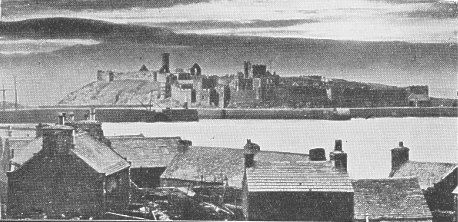
Fig. 52.-View of Peel Castle on St. Patrick's Isle, from the town. Photo. by G. B. Cowen.
Godred died here in 1187, and King Olaf also died at Peel, in 1237. We read of Reginald's descent upon it in 1228, when he burnt Olaf's ships and those of all the chiefs of Man. It seems, therefore, that Olaf must have had a stronghold here, though now no trace remains, unless it be the entrance tower. Our figure (fig. 52) gives a general view of the Castle with the Round Tower in the distance.
Rushen Abbey, on the Silverburn, in the village of Ballasalla and Parish of Malew, dates from the twelfth century, Ivo, Abbot of I'urness, having in 1134 received a grant of lands for the purpose from King Olaf. The Cistercian Monastery was probably raised on the site of the old Celtic Monastery of Saint hua, though there is no notice of buildings in the Chronicon Manniæ (kept by the Monks at the Abbey). In 1192, it is recorded that the "Abbey " was removed to Douglas for four years; and Deemster Callow's explanation of this seems a likely one, namely, that the Monks of Rushen were then employed in building or in re-building the Monastery or Nunnery of St. Bridget. The Church was not completed and consecrated till 1257. According to Chaloner's drawings, made in the seventeenth century, there were five towers of rude masonry, with square-headed openings. The only decided architectural detail is a plainly chamfered arch in the Church tower, one apparently of an arcade running north from the tower, three others now in the Grammar School, which was the old Church of St. Mary, Castletown, built at the end of the seventeenth century, having, as argued by Canon Quine, been removed after the dissolution (1541), when the furniture, ornaments, and building materials were sold and scattered.2 There remains a small vaulted passage, left standing at what must have been the west end of the Church ; on one of the key-stones of the arch is a socket for the suspension of a hook for a hanging light. Traces of inhumation have been met with in one corner. This was no doubt the " Cell " or the Sacristy which is usually found in this position in the Cistercian Monasteries. The proprietor, Mr. Cubbon, has commenced a careful examination of the Abbey remains; and, at the present time (March, 1914), has been able to disclose the foundations of the Cloistergarth, inner and outer walls, and of the Chapter- house which adjoins this cell on one side as the Church does on the other. The base of a light column of late twelfth- century work has been found in situ on a low sill to one side of the Chapter-house, looking on the Cloisters, and other very interesting discoveries are being made. In the cell have been gathered a few carved stones and other relics recently recovered ; also a fine coffin-lid, of which the exact original site is unknown (fig. 53).
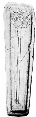 FIG. 53.- Rushen Abbey Coffin-lid.- From full-sized drawing by P. M, C. Kermode. |
It is of thirteenth century work, and of interest as being the oldest stone monument of English or Gothic architecture in the Island, and, marking the end of the old type illustrated by the Celtic and Scandinavian carvings referred to above. It may have been the tomb of Olaf the Black, who was buried here in 1237, or of his son Reginald, 1249, or, even more probably, of the last Norwegian King of Man, Magnus, buried in the Abbey in 1265. A square tower remains at the entrance to the Abbey grounds, which, on the east, would be well defended by the river, doubtless in those days deeper and at a lower level. An indication of the former level of the ground appears in the Refectory, now converted into a stable, where the tops of the windows appear almost on a level with the present floor. The pigeon tower would seem to be a modern building constructed out of old material.Near by, at the foot of the mill dam, which may have been raised by the Cistercians themselves, is the "Crossag," an example of a thirteenth century bridge, nearly in the same state as it was left by the builders. Its breadth is just 3 ft. 3 in. clear in the centre. At the western end is a small subsidiary arch, somewhat of the Carnarvon type, or square- headed trefoil, but an original portion of the structure, a type of which we have several doorways in Castle Rushen. (One is seen behind the elk in fig. 3, p. 17.) Some encaustic tiles of thirteenth to fourteenth century from Rushen. Abbey are shown in fig. 54. These were found during draining operations in 1884 and are almost certainly of local manufacture. Those figured are taken from a description by Ll. Jewitt in the Reliquary of January, 1885. Several more of the same kind together with some of larger size, red and plain, were found in 1905 on the floor of a former Chapel at the north tower of Castle Rushen, having no doubt been taken there from the Abbey ruins. They are now in the Museum. |
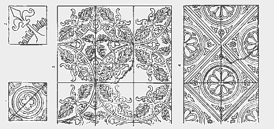
FIG. 54.-Encaustic tiles, from Rushen Abbey,
Bemaken Friary in Kirk Arbory (Cairbre), though founded by the Grey Friars in 1373, has scarcely any remains, and none older than the fifteenth century. In the Chapel, now a barn, may be seen the arches of the east window of Third Pointed characters, north door and window, and a south window-the square-headed trefoil and the position of piscina is clearly traceable. A wall forming the north gable of the farm house, 4 ft. thick, may have belonged to the Refectory. This-with Rushen-was confiscated by the English Crown in 1553.
A few of the Parish Churches, Braddan, Malew, Marown, Lonan and Maughold, show portions of walls, lights, &c., of the twelfth, thirteenth, fourteenth and fifteenth centuries. Maughold Churchyard is of unusual size and special interest. At the north end the site of a small Chapel, of perhaps the tenth century, has been revealed, and it appears to have had its cemetery separately enclosed. Nearer to the Church may be seen the foundations of another, while at the north-west and at the south-east traces have been met with of others. Remains of ancient walling and strong earthen embankments show that the enclosure was well defended, and we gather from the Manx Chronicle that at the time of Somerled's raid, 1148, it was a well-known Sanctuary, rich in treasure, and possessing amongst other things a miracle-working relic in the form of a Pastoral Staff. Most unfortunately this is lost, but doubtless it was of the ancient Celtic type containing the actual Staff of the founder, and has given the name to the " Stafands " adjoining, the estate which would be granted to its keeper in return for its safe preservation. At the Church gates is the beautiful Standing Cross (fig. 55), the only monument of its kind in the Island, possibly of about fifteenth century date, if not indeed contemporary with the fourteenth century east window; recently removed, and with some other details found in the course of repairs.
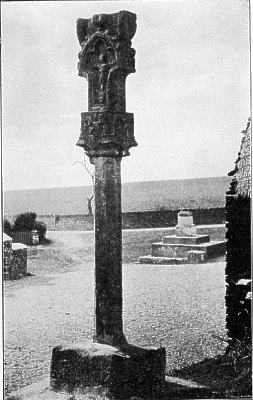
Fig. 55.-East face of standing cross at Maughold. From photo. by G. B. Cowen.
The light octagonal shaft, however, appears to be of earlier date and may have belonged to a twelfth century cross of which the head is now lost. The capital is adorned with four shields, one bearing the Three Legs, evidently here representing, the arms of Man. The others are not heraldic. Opposite to the first is one with a cinque-foil device of oak-leaves within a plain circle crowned by a little cross. At the one side is an open book below which hangs an oak-leaf, while on the fourth is a chalice probably having reference to the ecclesiastical character of the donor. The two side shields at the top show in one case an apparent heraldic bearing of two Chiefs wavy with oak-leaf below, in the other a rosette which., if really the " Tudor-rose," as has been supposed, fixes the late date of the head. The Rood proper bears a Crucifix on one face and figure of Virgin and Child on the other ; at one side of this is a large oak-leaf, at the other possibly a Knight in armour, kneeling. There has been another stone on the top, now lost. The carving is in very bold relief and the form of the crockets and whole appearance of it suggest a much earlier date than the late fifteenth century Tudor rose.3 There are also here some remains of twelfth century windows and a broken thirteenth century capital and fragments of toothed ornament.
The ruins of two ecclesiastical buildings of later date than those already mentioned are well worth preserving. Since the publication of our first Edition, both have been placed by their owners under the charge of the Museum Trustees. The first, on St. Michael's Isle, near Langness, was in ruins in Chaloner's days (1652-60). Ilt is rectangular, about 30 ft. by 14. ft. inside ; the walls, of large and small stones, being 3 ft. thick. At the west end is a single bell turret. The door, of which the sandstone jambs have disappeared leaving only one small piece to show their former presence, was on the south, and had a semi-circular head. There is a bar-hole in the thickness of the wall, suggesting that the building was looked upon as a place of defence. The east window, one lancet, arched ; the north has the head out ; the south and west were squareheaded, the two latter 12 in. wide outside, but with a splay inside to 2 ft. 10 in. ; the west window is evidently an enlargement of an earlier opening. The foundation of the stone altar may be seen under the east window with a slightly raised platform at its north end. Mr. Rigby thought he found traces of wall foundations across the building at points about 7 ft. and 16 ft. from the east end; between these were remains against the north and south walls as of stone benches. Any ancient mouldings or dressed stones in the building were probably of sandstone and have long since weathered away. The height of the side walls is only 10 ft. ; the walls were rough cast. The graveyard measures 64 yds. by 33 yds.
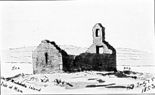
Fig. 56.-Chapel on St. Michael's Island.-From a sketch by Sir H. Dryden.
St. Trinian's, a twenty minutes' walk from Crosby, is pleasantly situated in a meadow at the foot of Greeba. The walls remain excepting the north, which in 1908 was re-built by the Museum Trustees who utilised it for the better preservation and the exhibition of remains of windows and arches found in clearing the ruins. The Church measures inside about 70 ft. by 19 ft. ; the walls, from 3 to 4 ft. thick, are built with lime cement of the local clay-slate, with dressings and quoins of red sandstone. Many pieces of Foxdale granite showing traces of moulding and carving were found scattered throughout the walls, having been taken from an earlier building. The plan, as usual, is rectangular and without architectural division save that the foundations of a cross wall were discovered at about 19 ft. from the east end, marking a square chancel ; this is not bonded into the side walls and may have formed a step and borne a screen or rail of woodwork. The east window, of two lights acutely pointed, is 4 ft. wide and decorated outside with a label moulding. On each side of the chancel are remains of a one-light window, and on the north is the priest's door. The nave appears to have had two one-light windows on the north, traces of one of them being shown on Sir Henry Dryden's sketch at a point about 9 ft. from the west angle of the wall (fig. 57) ; on the south are remains of one window and the doorway. Above the lancet west window, which has its sandstone dressings flush with the wall outside, is a turret for two bells. The south door, at 15 ft. from the west end, is 5 ft. wide inside and shows outside indications of a rounded arch. There is a hole for a strong wooden bar at the side of each doorway. The altar foundations still remain, about 12 in. high (see plan, fig. 57A) ; at its south side the removal of a large ash tree revealed an interesting pavement cross, the only example known in the Isle of Man.
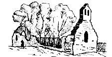
Fig. 57.-St. Trinian's Chapel, Marown, in 1853.-After a sketch by Sir H. Dryden.
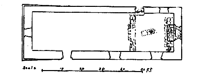
Fig. 57A.-Plan of St. Trinian's.
Remains of the stoup, of red sandstone, are seen in the wall by the south door, a more ancient one of a hard actinolyte rock from the other side of the valley was found loose on the floor. In the middle of the chancel was found a flagstone covering of a grave carved with a simple form of linear cross within an oval ring which seems to date from the sixth century, if not earlier; suggesting that there may have been a Church on this site from the earliest times. The existing remains may date from the twelfth or thirteenth century, but most of the granite work appears to belong to the eleventh, while some of the mouldings may be even older than. the tenth. Among the loose pieces may be seen parts of two carved capitals set on free shafts, belonging to the same side of a doorway which may have had more than the two orders represented. Very interesting are the carved capitals evidently for a double arch of a two-light window, showing a human head of Irish romanesque work. The granite bases of one of the orders of an arch remain at the outer corners of the main doorway, the rest of its stones, with others, having long since been carried away and built into the old Parish Church of Marown. The burial ground is no longer fenced, but its boundaries have been determined-enclosing a space of about an acre.
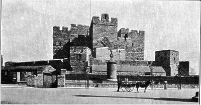
FIG. 58.-View of Castle Rushen from the south. From photo. by G. B. Cowen.
The finest of all the Manks historic monuments is Castle Rushen (fig. 58), and now that the unsightly modern additions and great accumulations of rubbish have been removed, all who behold it must be grateful to our present Governor, Lord Raglan, for restoring it almost to the condition in which it stood from the fourteenth to the seventeenth centuries. In our first Edition we mentioned that the late Mr. Armitage Rigby was preparing plans, one of which, of the ground floor, he kindly allowed us to reproduce (fig. 59). Since then Mr. Rigby, who was in charge of the work, gave a description of it, with illustrations, to the Isle of Man Natural History and Antiquarian Society (Proceedings, New Series, Vol. I., No. 7, pp. 342-349), and at the time of his death had all but completed a full account of the Castle, which we trust may shortly be published. He considered that the building now represented four main periods:-" (1) The old square Tower, probably built about the middle of the thirteenth century, and partly destroyed by Robert Bruce in 1313. The remains of this tower formed the nucleus of the Castle of the next period. (2) The fourteenth century Castle, incorporating the old tower, probably built by Sir William de Montaeute about 1344. (3) The Castle as further fortified for protection against cannon, said to have been done by Cardinal Wolsey early in the sixteenth century. (4) The Castle domesticated by the erection of the Derby House in the main ward and alterations to the Sallyport, &c." He points out that the view of the Castle from the harbour has been somewhat altered and dwarfed by the construction of the quay, while, from the town side, the height of the walls is dwarfed by the glacis of the third period. The Castle was found to be built on a mass of boulder clay which was at this point connected with the surrounding land by a narrow neck, the remainder of the circuit being separated by a " ravine." The entrance, on the sea side, belongs largely to the third period ; the neck of clay which here connects the Castle mound with the mainland was cut through and the space spanned by a plank bridge. At the end of the passage is seen the gate-house with a portion of its original portcullis still existing. In front of the door was a deep pit, since vaulted over. The gate-house contains a large guard room and a kitchen, with a tidal corn mill below the floor-the arrangements for lowering the corn being restored.
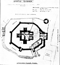
Fig. 59.-Plan. of Castle Rushen.
From the guard house one enters the main ward, octagonal in plan and surrounded by the walls of the second period. This contained numerous temporary buildings, such as stabling, brewery, bakery, blacksmith's and other workshops, remains of which were found at a depth of about 4 ft. below the surface. Most interesting was the unexpected discovery of a Mint with crucible, " runners," discs of copper, and a mass of slag and dross. Here is seen Derby House, added as a residence by the Seventh Earl of Derby. A stone was found there with the letters zc and n and the date, 1645-James and Charlotte, Derby, who resided here at that date. In the north-west corner are the steps to the curtain wall, which is strengthened at the salient angles by turrets and towers. This stood on the scarp of the ravine referred to above ; the widest part of this ditch was filled with water at high tides, and Mr. Rigby thought the narrower parts might have been filled by the overflow from the wells within the Castle, or, that possibly water might have been piped into it from the river.
From this wall the glacis may be seen on the south and east sides. In order to erect it at the scientific distance from the wall, the ravine had to be filled in, the space then becoming the gun ward. The glacis was originally protected by three drum towers, one of which, at the north-west corner, remains in an almost perfect condition.
A causeway leads from the gate-house to the entrance of the inner ward. The draw-bridge is commanded by loops from the guard rooms at either side of the entrance; then comes a portcullis and strong door, and, at the inner end of the passage, a second portcullis. Lord Raglan, after an exhaustive examination, discovered three holes in the floor of the chamber above, which commanded the space between this inner and outer portcullis ; no doubt they would be used for pouring boiling pitch or lead upon the enemy.
In the centre is an open courtyard surrounded by various chambers. It appears that the original tower was about 46 ft. square inside, and when the fourteenth century chambers were built within the walls there was left an open court which now, owing to the destruction of the east range, measures about 24 by 30 ft. The present ground floor is at the level of the first floor of the old Norse tower, the lower level of that tower being 8 ft. below where the cobble pavement was met with still existing. When the fourteenth century additions were made this was filled up with shore gravel upon which are built the walls of the added chambers. The lining of the well in the centre of the court has been raised to the new level. This lower chamber may have been merely a cellar as it is likely that the entrance was always at the present level. An access to this lower level was discovered on excavating under the gateway.
Externally the great double entrance tower was added upon the north, and towers, 20 ft. square, against the middle of each of the other walls. These were built solid to a height of 20 ft., containing chambers only on the upper floors. The open-air staircase, Mr. Rigby thought, occupied the position of the main staircase, delivering one on to a landing with three doors. That in front was the kitchen, to the left the buttery, and to the right the hall. The dais was at the further end of the hall, and behind that the withdrawing room. The fourth side, north, is entirely confined to defensive arrangements on this floor and the next, while on the top floor was the Garrison Chapel.
On the second floor the domestic arrangements are almost duplicated. Mr. Rigby's explanation of this is doubtless correct-that the Castle was to be the seat of Government as well as the military base for the Island, and that while the Lieutenant kept court in the lower hall, the Earl, as King of Man, when there, could have his own establishment above.
The iron staircase at the south-west corner of the tower is, of course, a modern insertion ; on each floor the space it occupies was a portion of the withdrawing room.
No trace of a fireplace has been found in the lower hall. A spiral staircase connects it with the upper hall and that with the battlements. The Chapel is approached from the battlements and was about 15 ft. square. On each side of the oriel window is a stone ledge on which rested the ancient altar ; on the south side of it a piscina, and on the north a small niche (an aumbrie, or equivalent of the credence table) for the sacred elements. A small grated window in the north angle appeared to communicate with a cell, conjectured by Mr. Cumming to have been the confessional. The clock, with its curious dial, which hides one of the windows, was a present from (queen Elizabeth, and the bell, as shown by the inscription, was supplied by James, tenth Earl of Derby, in 1729.
During its first stage the Castle, in 1313, was taken by Robert Bruce, but not till after a five weeks' siege. In the second period, in 1317, the Island was overrun by privateers, but the Castle was successfully defended by Sir Hugh Tyrel. In the fourth period it was besieged by Cromwell's troops under Col. Duckenfield, in October, 1651, when the treachery of the garrison gave the enemy control of the towers on the glacis. As a result of this and the news of her husband's execution, the gallant Charlotte de la Tremouille submitted to circumstances, but marched out with all the honours of war and with the distinction of being the last person to submit to the victorious Commonwealth.
The Governor has allowed the Trustees of the Manx Museum temporarily to house their collections in the Castle, but there is not sufficient accommodation to exhibit even the Antiquarian section to advantage, and it is greatly to be hoped that before long a suitable building will be provided expressly for the purpose. In the upper room of the entrance tower is a complete collection of casts of the sculptured stones and sepulchral monuments of the Island, copies being added of every newly-discovered piece, so that here the student is able to examine and compare the whole series under the most favourable conditions. Various cases of historic and prehistoric objects are arranged in the upper hall on the south side of the tower, including the very perfect skeleton of the Cervus gigantens figured above, p. 17. In the upper gallery, which was the withdrawing room of olden days, Lord Raglan has displayed a very interesting collection illustrating the history of the Island in a complete series, presented by their presentday representatives, of the Coats of Arms of former Kings and Lords of Man, and of the Governors since the revestment of the Island in the Crown.
Of camps and small earthworks of the Historic Period, besides those of earlier date still in use, the oldest recorded are those of Magnus, King of Norway (about 1098), of whom we read in the Chronicon Manniae that on his arrival in the Island he obtained timber from Galloway and erected many forts in the Isle of Man. It is difficult to identify these forts, but judging from what is known of such constructions in that period, we may suppose that some of the larger earthworks, showing inner and outer courts, such as Ballakeighan, near Castletown, may mark their remains. Some round camps also have been considered Scandinavian in origin, such as that still to be traced at St. Mark's, at the head of the valley where the Silverburn arises, and one which was at Ramsey just north of the Ballure stream, on the brooghs now entirely washed away. Mannan's Chair, in German, and one or two others on a larger scale may represent tribal forts of an earlier date. A notable earthwork is that at Lhergyrhenny, on the west slope of Snaefell, known as the Bow and Arrow Hedge in English, but this may be a corruption, as the old Manks name appears to have been Cleigh yn Arroo,i.e., Hedge of the Harvest ! It is 10 ft. high on the north side and 15 ft. on the south ; 12 ft. wide at the base and 6 ft. at the top. The ditch on the south is 9 ft. to 12 ft. wide, and can be traced N.N.E. and S.S.W. almost right across a neck of land between two deep streams, for about 550 yds.
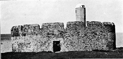
Fig. 60.-Derby Fort on St. Michael's Isle. From photo. by G. B. Cowen.
But the finest of the camps is that encircling the top of South Barrule (formerly Wardfell). On the northern side of the summit are traces of dry stone walls enclosing an irregular area of about 22,000 sq. yds., the thickness of the base of a wall on the northern side being upwards of 9 yds. The approach on this side is an easy ascent ; on the south the wall has been much narrower and weaker, and perpendicular to the brow of the cliff, which is inaccessible ; it is filled up inside so as to form a raised way or parapet. Some traces of a roadway into the camp are due to the fact that this spot was selected by the officers of the Trigonometrical Survey of Great Britain for the erection of their instruments for connecting with the triangulation of the British Isles.
At Ballachurry, in Andreas, is a fort, probably erected by James, seventh Earl of Derby, about 1641. It is rectangular, enclosing a space of 50 yds. by 40 yds. The earthen walls are 6 yds. thick, with four bastions at the corners, all surrounded by a wet fosse of ample dimensions. About the same date was built Fort Loyal, of small size, to command Ramsey Harbour, which in those days would be at the north end of the Mooragh.* The low mound of its foundations can still be traced. Probably remains on Gob-ny-Ronnag, Port Lewaigue, and elsewhere round the coast, were then either erected or strengthened and restored to use. On St. Michael's Isle is a circular embattled fort of stone (fig. 60), over the doorway of which is carved a coronet, with the date " 1647." The walls are 8 ft. thick, but not solid. Since the publication of our first Edition this has been taken over by the Museum Trustees as an " Ancient Monument," thoroughly repaired and supplied with ancient cannon from various parts of the Island. The modern lighthouse has been removed.
Of loose articles of the Historic Period some deserve at least a passing notice. We may consider them under the heads of-Weapons, Coins, Furniture, Ornaments, Implements and Utensils.
As regards the first, -we had examples of cannon of the time of Henry VIII. and of Charles I. at Peel, and of Elizabeth at Castle Rushen. At Bishopscourt are two small cannons from ships' longboats taken from Thurot in an engagement off Ramsey at the end of the eighteenth century, and others in Jurby and Bride are of the same period. Iron swords and daggers from Maughold Church-yard, and a broadsword and spear from Ballaugh village are or were in the Edinburgh Museum. " A basket-handled sword of great size and battleaxe " were found in a stone coffin in Patrick ; swords were found at Glen Meay, and a sword and spear-head at Ballachrink, Jurby, but we do not know where these now are. An iron dagger-handle from Michael is in the collection at Castle Rushen. A pike-staff found in Ballaugh curragh about 1889 is now lost. Very likely other such articles are in private collections of which we have not heard, and many no doubt have been taken off the Island or lost.
At Peel Castle have been found stores of granite cannon balls, most of which have been recognised by Mr. Lamplugh as of Foxdale granite. A few stone, and many small iron cannon balls have been found also at Peel and in the north of the Island.
The most notable historic weapon is the sword of state which used to be carried in procession before the sovereigns of Man, and is still borne before the Governor in the ceremonies at Tynwald. This was submitted to the authorities at the British Museum and considered to be of the twelfth century. Mr. B. E. Sargeaunt thus described this at a meeting of the Natural History and Antiquarian Society in 1910 (Proceedings [new series], Vol. L, No. 7, p. 395). " Blade, unsigned and without a mark, 29 in. in length, slightly more than 12 in. wide at the quillons, tapering to the point, grooved on either side for a distance of 62 in. from the quillons. Handle, 9 in. in length, composed of hardwood, terminating in a large worked pommel bearing on either side the design of three legs spurred (as those in the Arms of Man). The pommel, which is of steel, is circular, but flattened on the two sides bearing the designs already mentioned. It is some 2 in. in diameter. The quillons, which are almost straight but curled at the extremities, are 11 in. across; at their junction with the blade is seen. on either side a shield bearing the same design as is exhibited on the pommel." Ile thinks it quite likely that the sword at its birth may have been 2 or even 3 in. longer in the blade than it is now, and has no doubt that its manufacture was in the early part of the thirteenth century.
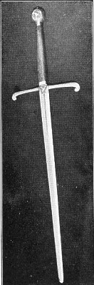
Fig. 61.-Manks Sword of State, Twelfth Century.
Our figure 61 is from a photograph taken for us by Mr. T. Keig, of Douglas.
A memorial of the ancient regal rights and prerogatives of the Island exists in its currency, coined and issued by the Lord with the sanction of the Tynwald Court. No notice is recorded of any insular money till 1679, when Governor Murray's copper penny became a legal tender. Subsequently various supplies of coin in copper were issued by the Derbys and the Dukes of Athol. These were stamped with the three legs and motto, and, on the reverse, the Eagle and Child, with the motto, " Sans changer," or some other insignia of the Stanleys, with the initials of the reigning Sovereign. The Duke of Athol stamped his copper coinage with the letter A, and a crown on the obverse. Our figure 62 is taken from Plate I. of the Manx Society, Vol. XVII. About 1825, paper cards or tickets, stamped for 1s., 2s. 6d., and 5s. British were legal currency; also copper pence tokens by small bankers in all parts of the country, with one pound notes of private bankers licensed by the Insular Government. Gold and silver coins of Saxons, Danes, Normans, English and Scottish have been found frequently, and it is stated that when the Mandevilles from Ireland pillaged the Island in 1315 they carried away large quantities of silver money which they found secreted.
Under the head of Furniture and Ornaments may be mentioned the stone reliquaries at Peel Cathedral, several rude stone fonts (pre-Reformation), as at Maughold, Bride, Marown, Jurby and Malew, and a stone holy-water stoup, of yellow gneiss, 4 in. high, and 6 in. to 7 in. diameter, recently found at a holy well by an ancient Keeill on Grenaby, Malew (fig. 63). At Maughold also there is a broken holy-water stoup made of a white sandstone. Other stoups of red sandstone or granite are to be seen at Peel, St. Trinian's, and elsewhere, the handsomest being one from the old Keeill at the Sound. Some interesting Church Plate of pre-Reformation and later date is preserved in many of the Parish Churches, and has been fully described and figured by E. Alfred Jones. At Jurby we have a beautiful silver chalice, which was figured and described in the Illustrated Archaeologist, January, 1895. The hall-mark shows it to date from 1521 ; the bowl is broad and shallow, stem plain and hexagonal, with hollow chamfered mouldings at the junction with knop and foot ; knop of six-lobed type, with angel-marks on the points; the foot is hexafoil, and the vertical edge of the base has a border of leaf and flower design."
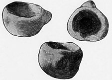
FIG. 63.-Stone Holy-water Stoup, at Grenaby. From a sketch by Beatrice S. Herdman.
At Malew is a latten Crucifix of the twelfth century, and a silver Paten of 1525. As regards the latter, the Vernicle in the centre instead of an Agnus Dei, or Hand in Benediction, establishes it as pre-Reformation, about seventy others being known to be in existence. Also, in the Church is a portion of a Staff covered with brass and the bronze top of a lantern.
Some fragments of stained glass from Peel Cathedral, now in the Manx Museum, have been described in Manx Soc., Vol. XXIX., p. 21. The fragments appear to be of different dates-some are Italian showing very delicate work. One piece showing the Manks Arms and Monogram of Archbishop Parker is known to have been in the choir in the days of Queen Elizabeth.
A curious wooden Mace in black and gold, now in the Museum, from the collection of the late Mr. Wallace, of Distington, was described by him as having been borne in procession before the Manks Bishops. The remains of a carved oak Rood Screen from the Nunnery Chapel may also be seen in the Museum at Castle Rushen. At Arbory Parish Church an interesting inscription by Abbot Ratcliff, carved in oak.
A few gold and silver ornaments have been preserved ; some, as a silver necklace and bracelet, found in Andreas in 1868, and gold and silver rings and bracelets found in Douglas in 1894, having been claimed as Treasure Trove, are now in the British Museum (see figs. 64 and 65). A few, like the Mylecrame Silver Cross, and the Gold Whistle shaped like a Cavalier's boot, found in the Fort at Ballacurry, St. Jude's, are in private hands. No doubt many have been carried away, lost, or destroyed.
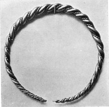
FIG. 64. Gold Armlet of Twisted Wires, Viking Period, from the Douglas Treasure Trove of 1894.
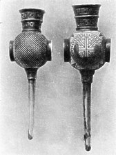
FIG. 65. Silver Pin of Fibula or Brooch, from the Douglas Treasure 'Trove of 1894.
Among implements, utensils and household furniture, must first be mentioned the querns* (figs. 66, 67 and 68), or hand-mills ("braamyn "), frequently of granite, which must belong to various periods ; some have been recognised as probably of the Iron Age, and some, as the " Saddle stones," may be a good deal older.
* One of these bears a simple cross-shaped design in low relief,
In later historic times the corn was dried in small kilns attached to the farm. Thrashing was performed with a flail (" soost ") composed of two stout and straight branches, fastened together by a thong of hide. The portion held in the hands was called " laueraghyn," and the head or part which beat the corn, " slatt-hoost." These have gone out of use within the last thirty years.
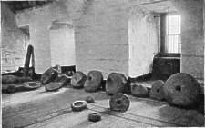
Fig. 66.-Manks stone querns in Castle Rushen.
Two men or women would work together, having a sheaf of corn spread out before them on the floor, which in that spot was made particularly strong and thick, as may still be seen in some old barns. Near the school, Sulby Glen, twenty years ago, gorse was crushed for cattle with a flail on a square floor against the wall consisting of a slab (or two slabs), and others on edge, bordering them. But generally the gorse was pounded with a heavy mallet. In winnowing, a sieve or tray, " Dollan-bennalt," was used in the open air. This was made by bending a thin band of wood, the ends overlapping and tied together by means of a tendon run through small holes bored in the wood. Over this was spread a sheep or goat skin, sewn on to the band by cords plaited through the skin and holes in the wood. Being filled with grain this was carried to the door or into a field, a sack or something being spread underneath. The dollars was moved gently backwards and forwards so that the wind might blow the chaff away. In grading the grain, and in the process of meal sifting, creear, a similar tray, but perforated, was used, holes being made in the skin by boring with a small red-hot iron bar. The " Peick," very much like the dollan, but smaller and deeper, was used for holding bonnags, cakes, meal, and such like, and was generally kept on the " latts " in the kitchen.
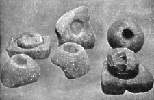
Fig. 67. Collection of Querns from Silverdale, Malew - ; upper and lower stones in position.
Straw taken from the flail without being broken (" gloyee ") was turned into rope, " suggane." Such ropes of straw and hay are still used to secure thatches of cottages and stacks. They are made by " twisters," rods or branches of willow or ash, bent in U-shape, the thicker end elongated and revolving inside a hollow wooden handle. The other end is bent by a string tied to its point, and attached to the first at the point where it enters the handle. A portion of the straw or hay being made fast to the loop, the bent rod is twisted by one man walking backwards, while the other is engaged in teasing out the hay gradually and evenly.
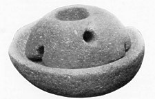
FIG. 68. Granite Quern from Bishop court ; 14 in. in diameter.
The long narrow spade used for digging peat is now seldom to be seen. Another implement gone out of use was the push-plough, of which there is a single example in Castle Rushen. This was used for breaking up hard ground before ploughing, much as the grubber is at the present time. Lingdrawers are still to be met with. These resemble sickles, some being toothed, some plain. Blunt sickles also were used for drawing " gibbons " out of the sand. The " Lister " was a straight-pronged trident used for spearing flukes. Straight-pronged iron forks, or " grips," were made by the local blacksmiths for farm purposes also before the introduction of the modern curved steel forks. These were used too in digging gibbons (the lesser sand-eel, Anamodytes tobianus).
In old days the " fidder," or weaver, was an important personage, most parishes having one or more hand-looms, but now the modern mills have taken their place. The old spinning-wheels also are fast disappearing. They all had the " quip-al," or distaff attached to them, so that the same wheel could be used either for flax or wool. Flax, commonly grown in the Island until some fifty years ago, when cut, was left lying for some time in water, then sent to the tuck mill, " Myllin walkee," to have the skin or bark torn off, after which it was combed by a " heckle," or card, into the condition of tow, when it was ready for spinning. Sometimes the carding of flax would be done at home, the heckles used, of which some examples may be seen in Castle Rushen, being exceedingly primitive. A " swift " was required for `minding the balls off into hanks, which were then ready for weaving into linen.* The spinning of wool for stockings or cloth was somewhat similar, only the quiggal was removed from the wheel, the " rolls " being kept on the knee. After the wool from the sheep had been washed and picked, it was carded with combs, " threden olley," and then, with a quick turn of the wrist, made into short rolls with the back of the combs. When two spools of wool had been spun, they were put on the " clowan broachey," reel bobbin or wheel spools; the spinning wheel being then turned the reverse way, twisted them together into strong " threads," ready for knitting into stockings, or for weaving in the hand-loom into cloth or dress material. If the thread was required in hanks, as it would be for making cloth, a " crosh-lane," hand-cross, would be used ; this crosh-lane was made of wood somewhat the shape of an anchor. The thread was put round it and thus formed into hanks. If, again, hanks were required in balls, there was the " thrown thross," winding blade, for that purpose ; in shape this was like the sails of a windmill, and, fixed in a wooden stand, revolved in something the same manner. One kind, after sixtv revolutions, made a little " clic," showing that a certain quantity of wool was wound, and then started afresh.
Miss A. Crellin,7 had been able to trace about forty-eight sundials. A curious one at Peel Castle is known as " the white line," and the only other public dial except those in the Churches is that which stands in the Castletown Market Place. It is dated 1702.
The others are in private hands, and are for the most part plain, a few only having inscriptions in Latin and others in Manks. The most interesting appears to be one which was in the collection of the late Sir John Evans, of Hemel Hempstead. It is dated 1774, and is of Poolvaaish marble. Another of the same material is owned by Mr. G. W. Wood, of Streatham, and the massive bronze gnomon is supported by the Three Legs. This dial with its pedestal of red sandstone is reported to have come from The White House, Michael, and appears not to be included in Miss Crellin's list.
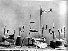
Fig. 69.-Old Manks Tanrogan lamp, cruisics and rush-light holders.
From a photograph by A. J. Moore. For the loan of this block we are indebted to the courtesy of the Publisher of "The Antiquary."
With regard to lighting arrangements, an original natural lamp used here until quite recently was the " Tanrogan," or large scallop (Pecten maxinius), the hollow upper shell of which made a natural saucer in which a wick of rag or rush would lie in solid or liquid grease, sometimes lard, sometimes fish oil, or goose-grease. The " Cruisie " is very rare. It has an oil vessel formed with a spout from which the wick " bitte " projects, and hangs from a hook provided with notches by means of which the vessel can be tipped forward gradually as the oil burns down. A second and larger vessel was fixed below is to catch the drippings of the oil. The iron rush and candle holder (fig. 69) is more common, but fast disappearing. For these, the rushes were cut in the summer, the peel removed excepting a narrow rib running from top to bottom, left to support the pith, and the cores thus obtained dried and bleached in the sun, while the strips of peel were twisted to form lankets for sheep. The cores were then dipped in scalding grease until thoroughly saturated, and after being allowed to cool were ready for use. The most simple type of iron holder for these rushlights had a thin point of the iron, about an inch long, split off for the purpose ; a further development was for the top to fork, the ends turning over. The usual form had the lower end of the iron stand, which was somewhat pointed, inserted for steadiness into a block of wood, generally cylindrical, or very slightly shaped. The upper end, about an inch in length, formed, with another piece of iron moving on a pivot, the jaws or nippers to hold the rush, the necessary pressure being given by a bent lever and weight at the other end. In a development of this the weight was formed into a ring or socket, which serves also to hold a candle (fig. 69). In general, however, this ring is deepened and the bottom closed. The total height of the holders was generally from. 9 to 12 in. ; sometimes the stem is set on three or four iron legs instead of in the wooden block. At Orrysdale is a curious spiral form in which the candle was raised or lowered by twisting a pin round and round in the spiral. Sometimes the holders were made to hang from a nail. Later, candles were cast in moulds made by local tinsmiths. These, which are now scarce, were long hollow cylinders tapering to a cone at one end, the tip open to allow the wick to be set centrally in the mould. Later moulds had a funnel-shaped reservoir at the top to prevent the melted tallow from overflowing. A specimen of an old Manx Tinder box, with flint and steel; sulphur matches, fragment of dip candle; and burnt tinder, presented by Dr. Clague, may be seen in the Museum.
Home-brewed " jough," made in many farmhouses, was kept in deep, narrow, earthenware " crockans " ; a large wooden plug filled the top, and the beer was drawn off by a smaller one near the bottom, called the " thalbane pluggane." These crockans differed in size and shape, but were all tall and narrow, holding some two or three gallons. The round wooden butter box, taken by the fishermen to " the herrings," would hold a pound of butter. The owner's initials were often roughly cut on the top of the lid with a knife. This and flat cakes, of flour or meal, " berreenyn," baked upon a " losh," or baking-stone, the circular flag placed over a peat fire, were all they would take with them, the rest of their fare consisting of the herrings, which they caught. As stated by Waldron (Manx Society, XI., 49), " the first course at a Manks feast is always broth, which is served up, not in a soup dish, but in wooden piggins, every man his mess. This they do not eat with spoons, but with shells, which they call sligs, very like our mussel shells, but much larger." The " piggins " are locally known as " noggins "-tumbler-shaped wooden cans, about 4 in. high, with one stave left projecting for a handle-in fact, the Scottish " luggie." Horn spoons, about 9 and 5 in. long, were made locally, but are now rarely to be seen. Spoons of lead and pewter were in use until about forty years ago, and several of the moulds are still preserved. They were made by old women, who used to go round the parish carrying their own moulds and crucibles or " cressets." The spoons were about 7 in. long, and were made, or " run," at a charge of a halfpenny each. The inside of the mould was smoked in the wick of a tallow candle ; this prevented the lead sticking, one smoking being sufficient for six spoons.
A drinking-horn would be handed down from father to son for many generations. Sometimes such a, cow's horn, " eairk," of a size (about 52 inches) to hold a satisfying measure of rum would pass from band to hand with a fishing boat " for luck." In some cases the tip of the horn was cut off, the smaller end being stopped with a bit of cork. We obtained recently, for the Manx Museum, one of each kind, which had belonged to Port St. Mary fishing boats for at least 200 years.
It is difficult now to get a pair of " carranes," the shoes worn till about fifty years ago. They were made of tanned, and sometimes of undressed, hide, that of a heifer making about four pairs. The smooth side was worn next the foot. They were turned up all round, and laced at the back of the heel with a thong of hide.
Settles of oak or deal were formerly to be seen in every chimney nook. There was but little carving, sometimes the back was open work, but generally plain. A few oak chests and some old armchairs, of the sixteenth to the eighteenth century, are in the hands of private owners, and it would be interesting to have them all figured and described. Miss Christian, Baldromma, whose will was proved within the last few years, set a good example by bequeathing such a chair, with the date 1685 carved upon it in bold relief, to P. M. C. Kermode, for the Manx Museum, in which she knew he took so great an interest. If this example were more generally followed we cannot doubt but that a very interesting collection would be formed illustrating the past history of the Island.
If the foregoing pages in any degree help to the establishment of such an institution as a well-equipped Insular Museum, by arousing interest in it, and by suggesting the character of its collections, so far as Antiquities are concerned, and, perhaps, by inducing our readers to secure for it before it becomes too late such articles as are illustrative of the past history of the Island, we shall feel that this little book has not been published in vain.
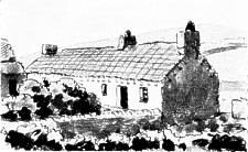
Fig. 70.-Old type of long Manks cottage.
From an unpublished sketch be Sir H. Dryden.
1 See Browne Willis (Survey of the Cathedrals, &c., London, 1727.)- " In King's Vale Royal, or Hist. of Cheshire, printed in Folio An., 1656, may be seen a Draught of this Cathedral and Kirk Patrick Church, the Abbey of Rushen, and Nunnery of Douglas," &c. ; also of the Episcopal Palace which stands in Kirk Michael Parish.
2 Yn Lioar Manninagh, III., p. 405.
3 We suggest that this is decorative and not the Tudor Rose.
4 In 1648 there is an account of a, Scotch ship having entered and plundered the place;. In 1651 it was handed over by Edward Christian to Col. Duckenfield.
5 List of Manks Antiquities. P. M. C. Kermode. Manx Society, XVII.
6 Manx Soc., XV., 107-109. Yn Lioar Manninagh, II., 227.
7 See an interesting article by Miss A. M. Crellin, in Yn Lioar Manninagh, Vol. II, p. 265.
8 Yn Lioar Manninagh, II, 38
|
|
||
|
|
||
|
|
||
|
Any comments, errors or omissions gratefully received
The Editor |
||