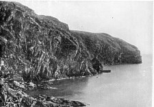
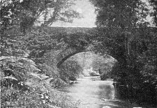
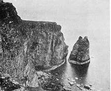
Spanish Head
[From Isle of Man by John Quine, 1911]
The early history of the Isle of Man is veiled from our knowledge. Though the veil begins to lift from over Britain shortly before the Christian Era, and Ireland comes into the light some three centuries later, there is a uniform lack of direct information about Man until the period of the Viking invasions. In this chapter we shall briefly mention the early authors who notice the island, and then consider what is known about the history of its name.
The earliest mention of an island in the Irish Sea occurs in Caesar's description of Britain (B.C.c.54). He says that Mona lies midway across the sea separating Britain from Ireland. The position so described is that of the Isle of Man ; but the name Mona is that of Anglesey, and at a later period was unmistakably applied to this latter island. From his knowing of but one island in this region of sea, it is obvious that Caesar's information was vague, but derived nevertheless from men with some definite knowledge of the Irish Sea.
The Roman conquest of Britain does not date from the expeditions of Caesar, but from the time of the Emperor Claudius nearly a century later (A.D. 43). The historian Tacitus describes the conquest of Mona by Suetonius Paulinus (A.D. 60), with details that clearly identify it with Anglesey. A little later the Brigantes, whose region included Lancashire and Cumberland, were conquered in the reign of Vespasian (A.D. 69-79); and Pliny, this emperor's intimate friend, in his description of Britain, mentions six islands between Ireland and Britain, among them Mona and Monapia-the first certainly Anglesey; the second, Man. Ptolemy, writing about A.D. 120, speaks of an island called Monarina, which is considered by some to be a mistake for Monava.
There is no written evidence that the Romans sent a military expedition to Man, and there are no vestiges of Roman occupation, such as stations or camps, on the island. This does not, of course, imply that the island had then no connection with the outside world. The importance of the trade connections of Ireland with Gaul in the centuries before and after the Christian Era is only now being realised, and there is every reason to suppose that the Isle of Man shared to some extent in this over sea trade. There was a Roman road from York to Preston, terminating on the Ribble at Freckleton, which was called the Port of the Segantii. From here, in clear weather, the island may be seen on the north-west horizon. The fact that the terminus of this Roman road from York to the shore of the Irish Sea was a port, implies that during the four centuries of the Roman occupation of Britain there must have been communication with the island. And in the same way a Roman road, a branch of Watling Street, went to Caer Segont opposite Anglesey, and through Anglesey to Holyhead, the great port for the Irish.
With a port on the Ribble in Roman times, a port at Ravenglass, and a Roman station at Lancaster, from which Man is visible in clear weather, communication with the island was simple and easy; and Orosius (A.D. 416) seems to have written on the basis of information derived from persons who had visited it, for he calls Man " Mevania of considerable extent, fertile in soil, and, like Ireland, inhabited by tribes of Scots [i.e. Irish]."
In Saxon times, Bede (A.D. 734), referring to islands in the Irish Sea which Edwin of Northumbria made subject to the English, calls them the " Mevanian Islands of the Britons." Later again, the various chroniclers whose work covers the Saxon period generally refer to Man as "Mevania"; one writer using the form Monaeda and Manavia. In the Saxon Chronicle, under date 1087, William the Conqueror is said to have (i) conquered Wales, (ii) obtained full rule over Mann-cynn (supposed to be Man), and (iii) purposed to subjugate Ireland.
Nennius, writing not later than the tenth century, speaks vaguely of an island, which he calls Eubonia ; Jocelin, writing in 1192, definitely identifies "Eubonia" with " Mannia," and this name Eubonia is used as late as 1393 in a record of the transfer of Man from the Earl of Salisbury to the Earl of Wiltshire. Welsh annals mention Eubonia (A.D. 584), and again (A.D. 684), and Eumonia (A.D. 987) ; but it is impossible to say what place the annalists had in mind.
The native name for the Isle of Man is Ellan Vannin, in which the first word means island, whilst the second corresponds to Irish Manann, the genitive singular of Mana or Mann, 'Man' The Welsh form is Manaw. Now it is interesting to note that the same name was also given in ancient times to a district in Scotland, where it survives in the modern Slamannan and Clackmannan. Prof. Sir John Rhys traces the name to an old Celtic Manavib, genitive singular Manavionos. What the origin of the name was it is impossible to say at the present day. But it is difficult to separate the ancient designation of the island from the name of the Menapii, a tribe in Belgium, and the Menapii, who dwelt in the south-east of Ireland, on the one hand, and from the name of the Irish Neptune Manannan son of Ler (the origin of Shakespeare's Lear) on the other. In Irish story Manannan has a special connection with the island, where he is still known as Manannan Beg Mac y Lir (Little Manannan, Son of the Sea).
On a twelfth century cross still standing at Kirk Michael in the Isle of Man, with an inscription in Old Norse and in Runic letters, the island is called Mön (probably pronounced Mann). The Goidelic Mana and Old English Monig (man-island) gave rise to the later Latin form which is always used in the Chronicles of Rushen Abbey. Subsequently the name was written either Mann or Man; and eventually and finally Man.
Man is more or less rightly named the Midway Isle. The shortest distances to the opposite coasts are, to Scotland (Burrow Head in Wigtownshire) 16 miles ; to England (St Bee's Head in Cumberland) 28 miles; to Anglesey ¢5 miles; and to Ireland (the Ards of Down) 38 miles.
The island lies, in elongated form, about N.N.E. and S.S.W., with a diagonal range of mountains from north east to south-west, at both ends terminating abruptly over the sea; these mountains being of the same slate formation as those of Wales and Cumberland. The island has therefore two districts, with general aspects south-east towards England and Wales, and north-west towards Ireland and Scotland. In clear weather from the various summits of the island one can see very plainly, as great mountainous masses, "the four countries"-the Galloway highlands, the Cumbrian group, the Snowdon range, and the Mourne mountains. And, given exceptionally favourable conditions of atmosphere, one can trace the coast border of southern Scotland from the Mull of Galloway to the Solway; the coast of England from Workington to Barrow; low-lying Anglesey backed by the Welsh mountains; and the Ards of Down from Strangford Lough to Belfast Lough. It is not without significance that North Barule and South Barule, the former at the north-east end of the mountain range and the latter near the south-west end, should be called "Barule," a corruption of Ward-fell, i.e. the Hill of Watch and Ward.
Spanish Head
On the eastern side of the island the mountains and their lateral spurs have a gradual slope; on the western there is more abruptness, and the spurs are in effect foot hills trending somewhat parallel to the main chain of mountains. Towards the southern end the slopes flatten out into levels on a formation of horizontally-bedded limestone ; but towards the northern end the alignment of the foot-hills abuts steeply on a wide alluvial plain. Inevitably the character of the scenery on these opposite sides of the mountain range is distinct ; nevertheless, from the fact that the island is remarkably bare of timber, the general characteristic of bare hills and fenced fields on their lower slopes is common to both sides of the island alike.
The extreme length of the Isle of Man, from Spanish Head at the south to the Point of Ayre at the north, is 33 miles; the extreme breadth, about midway, 12 miles; but generally the breadth is about 10 miles for the greatest part of its length. The coast line is about 80 miles; the area 145,325 acres, or 227 square miles, of which about a fourth part is mountain waste and common.
Snaefell, the highest mountain, reaches 2024 feet ; North Barule, 1842 feet: both these summits are near the north-east end of the range. South Barule (1584) and Cronk-na-Irey-Lhaa (1445) are similarly grouped near the south-west end. Between are five summits above 1500 feet, two above 1000 feet, and many lateral eminenceslittle short of 1000 feet. The abutments on the coast-except at the ends of the main chain-generally do not exceed 400 feet; Maughold Head (north-east) being 373, and Spanish Head (south-west) 350 feet. The Point of Ayre, the extreme northern limit of the island, is the termination of the alluvial plain, and is a low spit of shingle formed by the scour of the North Channel tides. The Stack of Scarlett and Langness Point at the south-eastern end of the island are low-the former, the margin of horizontal limestone beds ; the latter, slate jutting out from the over-lap of the limestones.
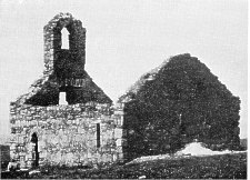
St Michael's Chapel on St Michael's Isle
Naturally one must expect many streams in an island of many mountains : and, not including the tributaries in every converging glen, there are twelve that enter the sea on the eastern side of the island, and fourteen on the western side. They flow for the most part laterally from the central watershed, and their courses are rapid and short. The Sulby River, however, entering the sea at Ramsey, has a course of ten miles ; and the rivers that debouch at Douglas, Peel, and Castletown have courses of about eight miles. All of them rise on the divide of the island, and flow parallel with rather than transversely to the mountain range.
Adjacent to Man, but widely distant each from the other, are three islets, the Calf of Man, St Patrick's Isle, and St Michael's Isle. There also was formerly a delta islet of considerable size at Ramsey, but it has been destroyed by the tidal bore in Ramsey Bay. The town stands on a fragment of it, and derives its name from the islet. The name is Scandinavian, meaning the Isle of Hrafn (raven). St Patrick's Isle at Peel, and St Michael's Isle at the north end of Langness, each with an area of about five acres, are rocky. Both are now joined by causeways to the main shore.
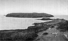
Calf Island
The Calf of Man lies half-a-mile off the south-west end of Man, separated by the Sound, through which runs a dangerous tide race, rendering the Calf accessible only at the slack of the tide. It is a plateau of 800 acres, with precipitous crags all round, admitting of a landing only at one point in the Sound. The highest eminence on the islet is 470 feet above the sea.
From the top of North Barule, looking south-west ward, one sees the summits of the mountain range of the island in zigzag line trending to South Barule.
On the east side there are several high transverse spurs, and successions of subsidiary lower spurs ; and generally the slopes on this side are parts of a uniform whole ; but glaciers, moving lengthwise of the island, have cut across the main spurs, and left their seaward ends to stand out as detached and rounded hills.
On the west side the secondary hills, perhaps as a result of more concentrated glacial action, have the trends of their direction, as also the intervening glens, more or less parallel to the main range.
The general form of all the mountains is rounded and smooth. Their rock formation is grey or blue slate, of the Cambrian system ; but there is much less of bare crag and rugged brow than is usually associated with the mountains of Wales and Cumberland. The smoothness of surface and flow of line characteristic of the Manx mountains are doubtless the effect of the ice of the glacial period, which, from the loftier Galloway and Cumberland heights, was pressed across the intervening sea-bed and thrust over the less elevated mass of the island.
The whole mountain region is treeless, and generally grassy. Some of the mountains, e.g. South Barule and Cronk-na-Irey-Lhaa, are covered with heather; and all of them have sparse patches of it, survivals of a growth that once covered the whole ; the heather having been persistently burnt off for the sake of the pasture of grass.
The glens are admittedly the most beautiful feature of the scenery of Man. On the eastern side of the island they are of a type different from that of those on the western side, the glen sides being little more than a continuation of the slopes of the hills above. But on the western side of the island the glens are characteristically of gorge or canon form, e.g. Glen Auldyn, Sulby Glen, Glen Moar, and Glen Rushen, and only in parts of the eastern glens, and on a much smaller scale, is there anything of the same form.
The island possesses one valley, as distinct from its glens, and its formation must be noted as a singular feature of general surface. At Greeba, between Peel and Douglas, midway of the island east and west, but considerably south of the middle of the mountain range, a deep gap cuts right through the wall of the mountains, down to 126 feet above sea level-very much as the Gap of Dunloe cuts through Macgillicuddy's Reeks in Kerry. This transverse hollow is to the Isle of Man what the valley of the Caledonian Canal is to Scotland-though no canal has in this case been led through. From the divide of watershed at the gap, streams flow both ways to join the Douglas and Peel rivers; and the highroad and railway between these towns pass through the gap without the severe gradients of other island routes.
It is usual to speak of the northern and the southern mountains, reckoning from the Gap of Greeba. The northern mountains, roughly speaking, have an area of 20,000 acres above the 800-feet contour line, the southern of g000 acres. But as in general the limit of cultivation is rarely above the 700-feet line, the total area of mountain waste and common is not less than 40,000 acres.
From the rugged coast to the limit of cultivation the general aspect of the island is that of a skirt of cultivated fields, fenced with sod or stone dykes, with whitewashed farm-steadings dotted wide apart and, on the uplands, without the grace or shelter of a tree. But, towards the lowlands, little clumps of trees, rather for liking than for shelter, are as a rule a feature of every homestead. The ash is universal on the island. The glens are generally as bare as the hillsides, except for the indigenous ash and occasionally the sycamore, which form straggling lines and clumps along the streams.
Quite distinct in character from the main part of the island is the Northern Plain. It embraces the whole of the parishes of Kirk Bride, Kirk Andreas, and Jurby; the main part of Ballaugh ; a considerable part of Kirk Christ Lezayre; and a minor part of Kirk Michael-in all nearly 25,000 acres, or quite a sixth part of the island. From its northern extremity at the Point of Ayre, looking south along the sweep of Ramsey Bay, one sees its margin of sandy brows and shore, seven miles to Ramsey at the foot of North Barule, while looking south west along the flats of sand and shingle, one sees again the sandy scarps receding into the distance along the west coast. There is a bend southward at Jurby Point, beyond which the plain gradually narrows to the limit of the sand formation in the parish of Kirk Michael; the whole distance being about 15 miles.
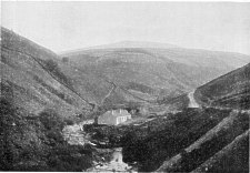
Sulby Glen and Snaefell
The plain is bounded on the south by the alignment of the abrupt hill fronts from Ramsey to Kirk Michael; and around its northern border sweeps a ridge of sandy dunes, on their seaward side gradually wasted by the ceaseless scour of the tides, and at the lower end of Ballaugh parish already swept away. On the landward side, between the dunes and the hills, are the Curraghs, between Ballaugh and Kirk Christ Lezayre on the one side and Jurby on the other. These are drained by the Lhen River, which gets through the dunes to the sea between Kirk Andreas and Jurby, and also by the Carlane River, which debouches between Jurby and Ballaugh, at a point where the dunes have already succumbed to the ravages of the sea.
The watershed of the island is the continuous ridge of mountains already described, and from it the streams fall east and west. Even from the Gap of Greeba, where the divide is only 126 feet above sea level, the streams are sent both ways from the medial line of watershed.
All the largest rivers have their sources very near the ridge of the divide, generally in cols or hollows between two neighbouring mountains. Thus in the southern group of mountains, the Silverburn, which enters the sea at Castletown (south-east), and the Glen Rushen River, which reaches the west coast through Glen Meay gorge, both rise at the Round Table hollow, between Cronk-na Irey-Lhaa and South Barule. And on the other side of South Barule, at the Airey, rise the Santon Burn to flow south-east, and the Foxdale River to flow north-west the latter joining the Rhenass River to debouch at Peel.
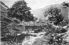
Tholt-e-Will Bridge, on the Sulby
Similarly in the northern group of mountains there are three such source-points on the watershed ridge in hollows between neighbouring summits. One is between Colden and Garraghan, from which spring the West Baldwin branch of the Douglas River (south-east), the Rhenass River (south-west) to Peel, and a branch of Sulby River (north-west) to Ramsey. The second point is at the Iron Gate, between Pen-y-Phot and Snaefell, from which the East Baldwin branch of Douglas River flows south-east and a branch of Sulby River north west. The third point is between Snaefell and North Barule, from which the Laxey River flows east, and the Glen Auldyn north-west to join the Sulby near its entrance to the sea.
In Sulby Glen
A characteristic of the rivers of the island is the large number of tributary brooks and torrents. Sulby River, with two main branches, each of which has a course of about ten miles, is the largest river. It drains a large moor land on the western slopes of Snaefell and the northern sides of Pen-y-Phot and Garraghan, from which was formerly dug the greatest part of the peat used as fuel in the northern parishes. It also drains the eastern slopes of the branching hills of Sartal, Slieu Curn, and Slieu Dhoo. In its course through Sulby Glen it receives five tributary torrents, two of them having lofty waterfalls. At Sulby it emerges on the plain, flows by the northern hill buttresses, receives the Glen Auldyn River near Ramsey, and enters the sea by the artificial freeway of Ramsey harbour. Formerly it had two estuaries, embracing the delta islet of Ramessey, on a fragment of which the town is now built.
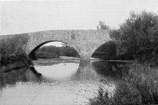
Sulby Bridge
There is a very beautiful waterfall at Braid Foss, a tributary of the Glen Auldyn River. Generally, however, it may be noted that, with the exception of the Dhoon Fall on the east coast, all the finest waterfalls are in the western glens; e.g. those already mentioned, and the Rhenass Falls, the Spoot Vane on a minor stream in Kirk Michael, the Foxdale Falls, and the Glen Meay Falls on the Glen Rushen River.
A picturesque feature of the Manx rivers to be noted is the number of old cornmills and woollen mills along their banks. There are four on the Sulby and three on the Glen Auldyn Rivers. On the Rhenass River there are eight; on the Foxdale, three; and three more on the lower course of these united streams. There are nine on the various streams that unite to form the Douglas River, six on the Silverburn, three on the Colby; and every considerable stream generally has one or two mills. But with the altered conditions of modern life this industry has decayed, and in many instances the mills are idle or even in ruin. Formerly the farmer class had all their foodstuffs ground at the local mill, and the poorer class bought their meal from the miller; all classes baking their own bread. To-day the bread-supply comes direct from the baker. The same remark applies to woollens and linen, and of the ancient flax mills, so numerous a century ago on the island, hardly a vestige remains. For like reason the smithies are much less numerous than formerly, smith's work being now supplied by the iron mongers of the towns.
Apart from the rivers flowing out of the mountains, there are two considerable streams which drain the Northern Plain, as already mentioned, the Lhen and the Carlane, at whose mouth sea erosion has destroyed the dunes along nearly a mile of coast. Kirk Andreas is also drained by trenches led into the Sulby River, and by a little stream entering Ramsey Bay at the Dogmills.
On the eastern side of the island, from south to north, the streams are as follows :-the Colby, Arbory, Silverburn (at Castletown), Santon, Grenwick, Crogga, Douglas (at Douglas), Groudle, Garwick, Laxey, Dhoon, Corna, Ballure, Sulby, and Dogmills rivers. On the western side, from south to north, the Dalby, Glen Rushen, Neb (united Rhenass and Foxdale, at Peel), Ballabrooie, Glen Cam, Glen Moar, Glen Willan, Glen Tronk, Ballaugh, Carlane, and Lhen rivers.
Though the island has no longer any considerable sheets of water, there were formerly many shallow meres or loughs, the largest of which was Ballaugh Curragh. In the valley between Douglas and Peel a chain of narrow loughs extended both ways from Greeba; and after heavy rains these levels are still covered with water. The Abbey Meadows near Castletown are a wide flat formerly under water, and in the first instance probably drained by the monks of Rushen Abbey.
In the north of the island a succession of large loughs once covered the inner side of the Northern Plain towards the foot of the hills, but most of this part has been drained. In a terrier of abbey lands in Kirk Christ Lezayre of the fifteenth century Mirescough Lough and Dufoch are mentioned with their fisheries. These sites are now drained by the channel of the Sulby River, which was artificially deepened and probably had its course consider ably altered for that purpose. Ballaugh Curragh still covers considerably more than 1000 acres, and in winter it is the haunt of innumerable wild duck. Peat is still cut in the Curragh, and crops of hay gathered in autumn, but except for persons with local knowledge it is an extremely dangerous venture to enter its maze of loughs, drains, peat cuttings, and clumps of dwarf willows in winter, when the waters are over the flats.
By Geology we mean the study of the rocks, and we must at the outset explain that the term rock is used by the geologist without any reference to the hardness or compactness of the material to which the name is applied; thus he speaks of loose sand as a rock equally with a hard substance like granite.
Rocks are of two kinds, (1) those laid down mostly under water, (2) those due to the action of fire.
The first kind may be compared to sheets of paper laid one over the other. These sheets are called beds, and are usually formed of sand (often containing pebbles), mud or clay, and limestone, or mixtures of these materials. They are laid down as flat or nearly flat sheets, but may afterwards be tilted as the result of movement of the earth's crust, just as we may tilt sheets of paper, folding them into arches and troughs, by pressing them at either end. Again, we may find the tops of the folds so pro duced worn away as the result of the erosive action of rivers, glaciers, or sea-waves upon them, as we might cut off the tops of the folds of the paper with a pair of shears. This has happened with the ancient beds forming parts of the earth's crust, and we therefore often find them tilted, with the upper parts removed.
The other kinds of rocks are known as igneous rocks, and have been melted under the action of heat and become solid on cooling. When in the molten state they have been poured out at the surface as the lava of volcanoes, or have been forced into other rocks and cooled in the cracks and other places of weakness. Much material is also thrown out of volcanoes as volcanic ash and dust, and is piled up on the sides of the volcano. Such ashy material may be arranged in beds, so that it partakes to some extent of the qualities of the two great rock groups.
The relations of such beds are of great importance to geologists, for by means of these beds we can classify the rocks according to age. If we take two sheets of paper, and lay one on the top of the other on a table, the upper one has been laid down after the other. Similarly with two beds, the upper is also the newer, and the newer will remain on the top after earth-movements, save in very exceptional cases which need not be regarded here, and for general purposes we may look upon any bed or set of beds resting on any other in our own country as being the newer bed or set.
The movements which affect beds may occur at different times. One set of beds may be laid down flat, then thrown into folds by movement, the tops of the beds worn off, and another set of beds laid down upon the worn surface of the older beds, the edges of which will abut against the oldest of the new set of flatly deposited beds, which latter may in turn undergo disturbance and renewal of their upper portions.
Again, after the formation of the beds many changes may occur in them. They may become hardened, pebble beds being changed into conglomerates, sands into sand stones, muds and clays into mudstones and shales, soft deposits of lime into limestone, and loose volcanic ashes into exceedingly hard rocks. They may also become cracked, and the cracks are often very regular, running in two directions at right angles one to the other. Such cracks are known as joints, and the joints are very important in affecting the physical geography of a district. Then, as the result of great pressure applied sideways, the rocks may be so changed that they can be split into thin slabs, which usually, though not necessarily, split along planes standing at high angles to the horizontal. Rocks affected in this way are known as slates.
Fault at Perwick
If we could flatten out all the beds of England, and arrange them one over the other and bore a shaft through them, we should see them on the sides of the shaft, the newest appearing at the top and the oldest at the bottom, as in the annexed table. Such a shaft would have a depth of between 10,000 and 20,000 feet. The strata beds are divided into three great groups called Primary or Palaeozoic, Secondary or Mesozoic, and Tertiary or Cainozoic, and the lowest of the Primary rocks are the oldest rocks of Britain, which form as it were the foundation stones on which the other rocks rest. These are known as the Pre-Cambrian rocks. The three great groups are divided into minor divisions known as systems. The names of these systems are arranged in order in the table, and the general characters of the rocks of each system are also stated.
With these preliminary remarks we may now proceed to a brief account of the geology of the island.
To the student of geology the Isle of Man offers a very good field for the study of the Primary rocks and of late Tertiary deposits, though it is quite wanting in the great group which we term Secondary rocks. Indeed, within a limited area, the Primary systems and Pleistocene and Recent Tertiary formations, their origin and sub sequent changes, could hardly anywhere be studied better than on our island.
| NAMES OF SYSTEMS | SUBDIVISIONS | CHARACTERS OF ROCK. | |
|---|---|---|---|
| TERTIARY | Recent Pleistocene | Metal Age Deposits Neolithic ,, Palaeolithic ,, Glacial |
Superficial Deposits |
| Pliocene | Cromer Series Weybourne Crag Chillesford and Norwich Crags Red and Walton Crags Coralline Crag |
Sands chiefly | |
| Miocene | Absent from Britain | ||
| Eocene | Fluviomarine Beds of Hampshire Bagshot Beds London Clay Oldhaven Beds, Woolwich and Reading Groups Thanet Sands |
Clays and Sands chiefly | |
| SECONDARY | Cretaceous | Chalk Upper Greensand and Gault Lower Greensand Weald Clay Hastings Sands |
Chalk at top Sandstones, Mud and Clays below |
| Jurassic | Purbeck Beds Portland Beds Kimmeridge Clay Corallian Beds Oxford Clay and Kellaways Rock Cornbrash Forest Marble Great Oolite with Stonesfield Slate Inferior Oolite Lias-Upper, Middle, and Lower |
Shales,Sandstones and Oolitic Limestones | |
| Triassic | Rhaetic Keuper Marls Keuper Sandstone Upper Bunter Sandstone Bunter Pebble Beds Lower Bunter Sandstone |
Red Sandstones and Marls, Gypsum and Salt | |
| PRIMARY | Permian | Magnesian Limestone and Sandstone Marl Slate Lower Permian Sandstone |
Red Sandstones and Magnesian Limestone |
| Carboniferous | Coal Measures Millstone Grit Mountain Limestone Basal Carboniferous Rocks |
Sandstones, Shales and Coals at top Sandstones in middle Limestone and Shales below |
|
| Devonian | Upper Mid LowerDevonian and Old Red Sandstone |
Red Sandstones,Shales, Slates and Limestones | |
| Silurian | Ludlow Beds Wenlock Beds Llandovery Beds |
Sandstones, Shales and Thin Limestones | |
| Ordovician | Caradoc Beds Llandeilo Beds Arenig Beds |
Shales, Slates, Sandstones and Thin Limestones | |
| Cambrian | Tremadoc Slates Lingula Flags Menevian Beds Harlech Grits and Llanberis Slates |
Slates and Sandstones | |
| Pre-Cambrian | No definite classification yet made | Sandstones, Slates and Volcanic Rocks |
Underneath all rocks is the primeval granite, the foundation material of the earth's shell. Very early granite crops out on the surface at the Dhoon, under an eastern spur of Snaefell ; and at Dun Howe, near Foxdale, on an eastern spur of South Barule.
Overlying the granite, and covering nearly three fourths of the island, are Primary rocks which may conveniently be termed Cambro-Silurian, i.e. of the same structure and formation as the Cambrian, the Ordovician, and the Silurian rocks of Wales. They were formed from beds of sediment in the seas of the remotest past. Subsequently they were raised, tilted, hardened, fractured, and in multitudes of ways altered. They afford, in their position, textures, and structures, clear evidence of how they were formed and what processes have been at work since their formation.
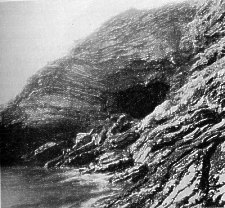
They consist of (1) clay schists, generally blue or grey, sometimes ferruginous and red ; (ii) harder gritty rocks, interstratified with the others; (iii) bands of felspathic greenstone, which was originally volcanic matter poured up and spread out, so as to be interstratified with the schists in the periods of their formation : and in addition there are subsequent intrusions of granite and porphyry, by which the schists have been rent and twisted. All this may be studied along the whole eastern coast from Langness Point to Maughold Head, as also along the western coast from Spanish Head to Peel, and in the western glens.
The schists in some localities lie nearly horizontal, as at Spanish Head, where they are seen in a cliff section over 300 feet high. Generally they dip at various angles. In many localities they lie on edge. The general dip on the eastern slope of the mountains is to south-east ; on the western, to north-west. On the latter side they are found actually folded over, just as one may fold over or earmark several of the leaves of a book.
In the neighbourhood of protruding granite are found the richest mineral veins, as, e.g., of lead mixed with silver, and of zinc and copper, in particular at Laxey mines underneath the mountain spur towards the Dhoon, and at Foxdale mines on the slope of South Barule. Iron has been mined at Maughold Head and copper at Bradda.
Along the strike of the schists from south-west to north-east are found veins of snowy quartz ; one at Fox dale being 30 feet thick. Great blocks of this stone are found in many burial cairns of the early inhabitants of the island.
Besides the movement of upheaval there has also been intense lateral pressure. This has caused much folding and crushing. The Chasms, a picturesque coast feature near Spanish Head, were formed by a lateral movement still in process, by which blocks of the strata have been pushed on a sloping underbed ; and the Chasms are the vertical clefts between immense masses detaching them selves successively from the hill. The "Sugar Loaf" is one of these cubes quite detached and isolated.
The thickness of the Cambro-Silurian beds is enormous, certainly many thousands of feet. As to fossils, none but a few undetermined coralline forms have as yet been discovered. The Manx slates have no true cleavage as in the case of the Cambrian slates of North Wales, and consequently are nearly useless for splitting into roofing slates ; but they furnish the greatest part of the building stone used on the island.
Sugar Loaf Rock
Along the west coast for two miles north from Peel are found Old Red Sandstones and conglomerates to a thickness of 300 feet, resting somewhat horizontally on the upturned edges of the older Cambrian schists under neath. These sandstones are calcareous, not rich in fossils, but containing the coral, Favosites polymorpha, and a few other forms characteristic of the Devonian system. On the south-east coast, near Derbyhaven, is also found Old Red conglomerate to a thickness of S0 feet, resting on the tilted slates of Langness. It is merely a long patch of outcrop ; and is in turn overlaid on the landward side by rocks of the Carboniferous system. Near Peel also there formerly existed Carboniferous limestone resting on the Old Red formation, but in recent times the whole mass has been quarried away and burnt for lime.
With the exception mentioned, the Carboniferous rocks are limited to the south-east fringe of the island, extending from a point two miles short of Spanish Head eastwards to Santon Burn: the inland extent being three miles from Scarlett to Silverburn Bridge. This formation consists of (i) Lower Carboniferous beds, (ii) Upper Carboniferous beds, and (iii) " Black Marble " schists.
The Lower Carboniferous beds are by far the most extensive in area ; the limestones being burnt for lime at Port St Mary, at Scarlett, and at Ballahott and Billown two miles inland, and containing all over the area a considerable number of the usual characteristic fossils. The Upper Carboniferous beds, in parts consisting almost entirely of fossils, cover only a limited area between Balladoole and the shore, and are much dis located by trap dykes, indicating great volcanic activity at the period of their formation. Felspathic beds are interstratified with the limestones and near the trap dykes the limestones are much crumpled and folded, burnt and altered in texture, and in some parts converted into pure dolomite.
The Stack of Scarlett
At Poolvash over a small area are black schists of still later date, laid down after the volcanic action had quite subsided. Their date probably verges on the period of the Coal Measures; the latter, however, are not represented on the island. The Poolvash beds are known locally as Black Marble, and from the Poolvash quarries were obtained the slabs that once formed the steps of St Paul's Cathedral.
The whole south-east coast region is intersected with trap dykes cutting through the older rocks, both at Langness and at Scarlett ; but a definite centre of most violent volcanic action was at Scarlett, Scarlett Stack being a basaltic pile, with the limestones around it half fused by the heat.
After the Carboniferous Period a subterranean up heaval on a large scale affected the mountain chain of the island. The evidences of this are well seen in the dip of the slates on both slopes, and in the tilting of the over lying limestone ; as also in the protrusion of new dykes of greenstone. A remarkable fault at Perwick, where the limestone ends beyond Port St Mary, also illustrates this upheaval, and shows also another geological process, namely denudation, which completely planed away the Carboniferous beds off areas over which they formerly spread.
There are, as we have seen, no Coal Measures on the island, and no rocks of either the Secondary or the earlier Tertiary Period. Yet a boring at the Point of Ayre proves the existence of Permian sandstones several hundred feet below the surface, and possibly extending under the Northern Plain. There is a probability that as chalk is found in County Antrim it may have extended over to Man : at any rate the immense forces of denudation at later periods could account for its disappearance.
Of the period of Pleistocene and recent deposits the island is a treasury of examples for the student. Over the Northern Plain, and over the whole island-indeed, even over the mountain slopes-are spread vast accumulations of till or boulder clay, later clays, sands, gravels, loam, and boulders, derived from rock materials both local and distant. The rock surfaces, wherever laid bare, show the polishing, grooving, and scratching of glacial movement. The boulders in the till show like effects ; and among these are chalk flints from northern Ireland ; granites, limestones, and Permian sandstones from southern Scotland and Cumberland ; even ground-up Lias with its characteristic fossils from east Cumberland-all worked by the glaciers of the Ice Age across what is now the bed of the sea, and even thrust over the mountains of the island, finally to remain deposited in every hollow and over every slope when the Ice Age had passed away.
To explain the drift gravels and raised beaches resting on the till, especially towards the coasts, it is usual to assume that during the Ice Age the island was submerged and that there followed a period of slow upheaval. The Northern Plain became connected with England, Scotland and Ireland-as were these countries with the continent of Europe. In Ballaugh Curragh and in the valley of Glenfaba complete skeletons of Cervus megaceros or Irish elk have been found, and one of them is preserved in Castle Rushen Museum.
The raised beaches of the island are found at various heights from 20 to 200 feet above the present sea level. At a level of from 12 to 20 feet the whole coast is marked by a terrace, indicating a long stationary period, since which the upheaval has been resumed.
During the Ice Age this region had conditions of climate such as now obtain in the Arctic regions. When milder conditions prevailed, with upheaval in progress, there still remained local glaciers on the Manx range, and traces of their action are visible in every glen, especially in the gravel moraines at the openings out to the lowlands, e.g. at Glen Auldyn, Sulby Glen, Ballaugh Glen, Glen Willan, and at St John's in Glenfaba valley. There must have been many small lakes too, on whose margins were laid the freshwater sands and gravels still found on the glen sides.
Fine deposits of yellow sea-sand are found in terraces 200 feet high at Douglas on the east coast, at Glen Willan on the west coast, at lower levels again in the St John's valley two miles inland, at the Congary a mile inland, and on the rampart of sand dunes around the Northern Plain. On these ancient levels are found the small flint weapons of Neolithic man-in certain localities so numerously as to indicate quite large settlements.
Through later periods the torrents in the glens have cut canons through the old till, and scarped the freshwater sands and gravels on the glen sides. Peat mosses have been formed, in which are found darraghs or trunks of bog-oak. To a later period belong the crannogs or pile dwellings, some remains of which are found in drained spaces of the Northern Plain.
Nature is unresting in its work. With the erosion of the sea, Ramessey Isle at Ramsey has all but disappeared, Sandwick Cove near Castletown has become open shore, and Cregmalin Green at Peel has disappeared all but a strip along the brows. These changes have taken place in historic times. But even within living memory much of Hango Hill at Castletown has been destroyed; while along the coast from Peel northwards to the Ayre the sea is constantly washing away the sandy brows, and at the same time heaping up shingle and adding to the beaches around the Point of Ayre.
The soil of the island may be inferred from the above to be generally a subsoil of stiff clay over the greater part of the country ; with sandy tracts in Kirk Bride, on the west of Kirk Andreas, in Jurby, and in parts of Kirk Michael, and Kirk German. There are large spaces of peaty soil along the borders of the northern curraghs, in the central valley, and in various hollow patches on the slopes of the uplands. In Kirk Andreas and Kirk Bride there is a marly loam with vast deposits of marl under neath; and here and there in patches in Jurby and Kirk German the subsoil is almost pure brick clay.
|
|
||
|
|
||
|
Any comments, errors or omissions gratefully received The Editor |
||