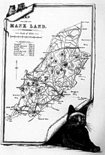
W.S. Whitworth did all the many illustrations for the book - the map is drawn on a scroll with two mice at top left hand corner and a cat (?Manx) bottom right - placing illustrations in fancy frames would appear to be his trademark as most other illustrations follow this approach. Title - Map of Manx Land
Shows the newly opened railways Douglas - Port Erin and Douglas-St Johns-Peel and Ramsey.
Some names are incorrect - Derby Castle rendered Castle Derby, Kirk Manghold instead of Maughold but otherwise shows major hills, roads and tourist locations
Published in
E.P.Stokes The Barrow Route to the Isle of Man London: Hazel,Watson and Viney 1883 - an advertising book published by the Midland Railway Co and the Barrow Steam Navigation Co to publicise the route to the Island from London via Barrow, the map is on page 35.
|
|
||
|
|
||
|
Any comments, errors or omissions gratefully received
The Editor © F.Coakley , 2008 |
||