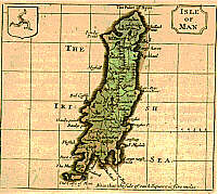
 John
Seller, 1695
 John
Seller, 1695
 (2) 1777 |
Size: 95mm x 150 mm 1:445,000
Based on Speed - the plates were used in period 1695 - 1701, then in 1777 re-worked to remove Seller's name and used in Grose's Antiquities
(1) The Island of Man by John Seller
Chubb CXVIII Skelton 115
66 coloured maps maps of Eng counties accomp. by page of text
Anglia Contracta. or A description of the Kingdom of England & Pricipahty of Wales in several new Mapps of all the Countyes therin Contained by John Seller Hydrogapher to The King 1695
1696,1711,1703 - Seller's History of England
1701 59 uncol maps - Camden's Britannia Abridged
(2) The Isle of Man
Chubb CCXLVII
55 of the plates were re-used by Francis Grose - new titles placed in panels formed by double lines but Seller's name not included - other trifling additions outside county borders but maps do not appear to have been touched.
A fine work in 4 vols maps printed at top of upper part of small folio page
Supplement to the Antiquities of England and Wales by Francis Grose
Esqr FAS
London Published for S Hooper No 212 High Holborn 1777-87
Again reprinted 1783/87 (maps printed at top of large Octavo page with text below and continuing on rear
The Map was lithographed and appeared in The Old Historians of the Isle of Man Manx Soc vol XVIII 1871 - imprint under outer box "G. Waterson & Son Edin. Photo Litho - 116mm x 137mm
|
|
||
|
|
||
|
Any comments, errors or omissions gratefully received
The Editor |
||