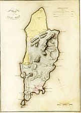
Map of the Soil of the Isle of Man
Size: 235mm x 180mm 1:232,000
NE to top. Explanation "Sand and Sandstone are Coloured ... Yellow / Slate ... Grey /Limestone... Red"
Shape based somewhat on Mackenzie (?) but with Pt of Ayre reduced - hills mainly indicated as ridges with small hachure. Possibly first geological Map of Island.
Imprint " Neele Scult 252 Strand" - Samuel John Neele (1758-1824) + sons James & Josiah were well known London engravers who engraved the maps for other counties in this series eg Sussex 1813;Berkshire 1813 as well as for Basil Quayle's map of 1794.
William Sherwood(1776-1837), born in Bristol worked for a Mr Symonds in Paternoster Row who died (or retirid) in 1806, Sherwood continuing the business with Neely & Jones.(Kingsley p105). Sherwood, Neely and Jones published other "General view of the Agriculture..." .
General View of the
Agriculture of the Isle of Man with Observations on the Means of its
Improvement /Drawn up for
the consideration of the Board of Agriculture and Internal Improvement By Thomas
Quayle Esq
London: Printed by W Bulmer and Co Cleveland Row St.James
Sold by Q and W Nicol, Booksellers to His Majesty, Pall-Mall, and Sherwood,Neely
and Jones, Paternoster-Row 1812
Price 7s. 6d boards
(reprinted with earlier Quayle 1994...)
EMIoM p42
|
|
||
|
|
||
|
Any comments, errors or omissions gratefully received
The Editor |
||