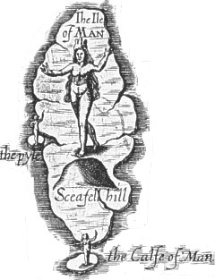
 William Hole + Michael Drayton, 1622
 William Hole + Michael Drayton, 1622
Map 9 - Lancashire + IoM
Based very loosely on Saxton?
William Hole engraved the title page for the 1st edition (1612) and is assumed
to have engraved the maps.
12 new maps in part 2 (maps in part 1 originally published 1612) illustrating
songs by M Drayton
Little geographical value; only rivers and major hills shown (probably as decoration!) (Snaefel misplaced in South of Island!) with allegorical figures placed at rivers etc.
This long poetical work is in 30 parts or 'songs ', of which the 27th describes Lancashire and the Isle of Man. The factual information follows Camden's description, but Drayton's treatment has a quality all its own
 |
The Sea-Nymphs with their Song, so great a coyle doe keepe, (Note: The Virgivian = the Irish Sea, and is presumed
to derive from Ptolemy-Mare Virgivium. |
Chubb XXXV; Skelton 13
A Chorographicall Description of Great Britain by Michael Drayton Esquire
London, Printed for John Marriot, John Grismand and Thomas Dewe 1622
The second part, or a Continuance of Poly-Olbion from the eighteenth Song
London Printed by Augustine Mathewes for John Marriot, John Grismand and Thomas
Dewe 1622
Reproduced 1890 by Spencer Soc.
|
|
||
|
|
||
|
Any comments, errors or omissions gratefully received
The Editor |
||