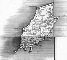
 Cary 1794
 Cary 1794
 IoM from sheets 47,56 & 57 on 1794 edition |
 Bacon ?1877 |
 Bacon 1883 |
Cary’s New Map of England and Wales with part of Scotland.
On which are carefully laid down All the Direct & Principal Cross Roads, the Course of the Rivers & Navigable Canals,
Cities, Market & Borough Towns, Parishes, & most considerable Hamlets, Parks, Forests Etc. Etc. Delineated from
Actual Surveys; & materially assisted from Authentic Documents Liberally supplied by the Right Honourable the Post Masters
General.
Fully detailed map of England & considerable part of Wales as well as Scotland upto Edinburgh & Glasgow.
Gives special emphasis to the roads.
Engraved as 81 sheet map which if borders removed will form a wall map or, as commonly found, bound into atlas (Sheet 80
= title, 71 = dedication) together with a guide to tracing a route and an index which was published separately. Sheet 62
is an index map, 72 Explanation and 63 scale of miles.
According to Fordham [Ford1925]p47 this is the first map which uses the meridian of Greenwich rather than of St Pauls London.
Fordham does not mention an earlier edition than 1794 though the BL does quote a 1792 edition.
The Index was updated and extended in 1804 and is the one generally found - it served as the basis for deteriming postal
costs as.decisions were based on Cary's tabulated milageag between post towns.
Sold at “Price in Boards, with the Index, £2.8s.6d.” though raised in 1817 to £3.13s.6d.
The IoM is found on sheets sheets 47,56 & 57 with the majority (Dalby point + Onchan Northwards on sheet
56, Maughold head on sheet 57 with south on sheet 47.
Shape & Roads from Fannin - hills indicated by light hachures but not named
Names often inaccurately transcribed: Kirk Lonnon, Kirk Conion
The standard format for each sheet is:
Ca(ib): sheet number in bold with adjacent sheets indicated
Imprint Ce(os):”Published by J.Cary June 11 1794.” (sheets 56/7)
“…June 1st 1794.” ( sheet 47)
Editions
(1) as described above
(2) Re-engraved plates in 1816. Position of Island shifted to NE so majority (N of Douglas Head) now on sheet
57 (+significant changes to coast of Scotland) - sheets 48,56 & 57
Some changes to names Peeltown replaced by Peel;additional names Cragmallan,Balebui,Mulin-y Chilea etc
Hills indicated by heavier hachuring though not named; ‘hairy sausage’ West of Sneafell + N-S plateau indicated
East of Sneafell.
No imprint on individual sheets
New Map …2nd Ed
London: Published Septr 2 nd1816 by J.Cary …181 StrandNew Map …2nd Ed
London: Published Aug 3 rd1822 by G&J.Cary …86 St James StreetNew Map …2nd Ed
London: Published May 1 st1824 by G&J.Cary …86 St James StreetNew Map …2nd Ed Corrected to 1828 (but still keeping 1824 date!)
London: Published May 1st 1824 by G&J.Cary …86 St James Street [1828]
(3) Re-engraved plates in 1830. on sheets 48,56 & 57 ?
According to Fordham this edition saw considerable changes to rivers etc [ not checked this edition]
New Map …2nd Ed Corrected to 1830 (though imprint of earlier state)
London: Published May 1 st1824 by G&J.Cary …86 St James Street [1830]New Map …2nd Ed Corrected to 1832
London: Published May 1 st1832 by G&J.Carynote return to earlier imprint of 1794 plate
New Map …2nd Ed Corrected to 1832
London: Published June 11 th1834 by J.Cary Engraver & Map-Seller, 181 Strand
Plates acquired by Crutchley in 1853 but not used? G.W.Bacon bought plates at Cruchley's sale in 1877 and started to issue them in 1883 after updating railways etc.
(1) British Isles [sheet] 3 - Railways added (very inaccurately),IoMR + MNR;
Submarine Telelegraph cable Ramsey to St Bees Hd shown
Joins of original plates can be seen e.g. in the misalignment of the sea shading around the Island
IoM on sheet with Whitehaven
(2)New Ordnance Atlas of the British Isles with Large Scale Plans of Towns
London G.W.Bacon 1883 {BL Maps 10 d 28}
subsequent use in Bacons's Cycling Road Map of England in 7 sheets(c1885)[not checked] + numerous transfers upto late '20's
EMIoM p42
|
|
||
|
Any comments, errors or omissions
gratefully received The
Editor |
||