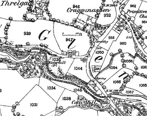
Extracted from O/S 25"/in plan of 1868 [Sheet IX 14]
Extracted from O/S 25"/in plan of 1868 [Sheet IX 14]
Glenmaye village lies some 4km south of Peel at the junction of the road to Dalby with the pre 19th main route to Castletown via Round Table - the Dalby road, exiting mid base of plan falls quite steeply down hill towards the river towards the bridge (off plan) before turning sharp east towards Dalby - the Castletown 'road', now merely a footpath some of which is incorporated in the Bayr ny Skeddan long distance path can be seen exiting mid right on the plan.
Kneen derives the name from "Glion muigh, (Ir. Gleann mbuidhe) 'Yellow glen.' In Old Irish glenn was a neuter noun,
which caused eclipsis, hence the change of buigh,'yellow,' to muigh. Streams often received this name, yellow, on account
of the muddy or clayey colour of the water, or from being impregnated with iron, and glens usually took their names from
the streams which flowed through them.
This name has been popularly translated Glen Mea, 'fat or luxuriant glen;' but the pronunciation does not admit of this."
The first Primitive Methodist Chapel can be seen at the entrance to the village - the later Chapel postdates the plan and occupies the field numbered 958 on the plan - both can be seen the the section from the postcard - for long the old chapel was a sunday school and later a small meeting room - a new house now occupies the spot.
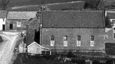
The two chapels in Glenmaye
 Looking south - the small section of the wall on left is that of the Wesleyan Methodist Chapel, |
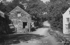
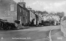 Looking north up from near entrance leading to Waterfall Inn probably c. 1920 |
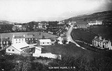 Looking north, taken from south of field 1044 |
The postcard image looking north is thought to date from c.1912 - one of the houses, the second down from the entrance to Craggnashen, appears to be thatched whilst on the image looking south, possibly dating from 1921 it could be slated.
Thatched house
The Waterfall at the head of Glenmaye had been a tourist attraction from the Victorian period - in 1861 census some 20 houses, with several men & sons working in the nearby lead ore mines, whereas in 1851 only two were associated with the mines with many men combining role of agricultural labourers and part time fishermen.
Not far off is the valley of Clanmy, now called Glenmay. This is the prettiest spot upon the island, and a most delightful one. It is, as its name imports, a glen, with deep, rocky, woody banks; in some places nearly perpendicular, terminated by a rivulet murmuring over the rocks, and, in one place, forming a cascade. The scenery here is highly romantic. The ground is well covered with the chesnut, the lintel, and the ash, apparently all planted. The northern bank is a perpendicular rock, of the height of sixty feet, here and there making its appearance through a covering of luxuriant ivy: at the top and bottom the holly flourishes. The southern bank, though not perpendicular, is very steep and well wooded. The valley winds considerably, and by excluding foreign objects renders the scenery more romantic. The spectator descends by a circuitous path, Toward the sea the glen continues pretty, but the wood of the southern side soon disappears. The bottom was too rugged, and the sides were too steep to permit my intended ramble through it. Being obliged to leave it, I walked on the top of the bank, and when, on the first opportunity, I again descended, found its beauty much diminished. Above the fall is a mill and above this where the vale opens, are a few cottages, pretily situated, with trees about them
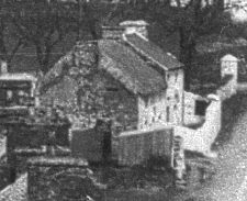
The little mill above the waterfall is Cringle's mill just to the south of the bridge - demolished many years ago in order to widen the road
Looking north - the village is around the bend north of the bridge
I have one postcard dating from pre 1907 which is labelled Glen Maye, but have not yet determined the property.
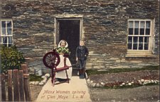
Manx Woman spinning in Glen Maye
This farm a little to the west of the village has long been associated with the Quirks
David L Moore The Beekeeper of Glenmay self-published 2012 (printed by Bridson + Horrox) + available from author - based on letters etc of Lancelot Quayle (1865-1950) paints a portrait of Glen Maye
|
|
||
|
|
||
|
|
||
| Any comments, errors
or omissions gratefully received The
Editor © F.Coakley , 2010 |
||