As the old schoolboy adage has it "History is about chaps whilst Geography is about maps". Maps are covered elsewhere - geography here will be interpreted in a wider sense of man's use of Man! Such work obviously builds on Geology which studies the physical mechanism by which the Manx landmass and soils took on the form we are now familiar with. I assume that all are familiar with the Island's position in the centre of the Irish Sea and approximately at the geographic centre of the British Isles.
Lamplugh's opening description of the key topographical features is a good summary:
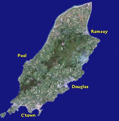
The predominant feature in its stratigraphy is the central ridge of slate and greywacke, which seems to have constituted an insulated tract at as early a date as the beginning of the Carboniferous Periods This prototype of the present Island appears afterwards to have been enfolded and obliterated by the sediments of later times; but with the progress of denudation the old ridge has once more emerged from beneath this mantle.Its insular character is as well maintained in its physical as in its geological features. The erosive agency of the simple drainage system, descending radially to the sea from the central hill-ridge, together with that of the waves which surround it, is adequate to explain all the contours of its present surface
This central ridge so visible in the satellite image, runs NNE-SSW and is bisected by the central valley (Douglas-Peel); the ancient division of the Island into North and South sides approximately follows the watershed of this ridge - the administrative centres being originally Castle Rushen(Castletown) for the southern parishes and Peel Castle for the northern.
To the north of this hill ridge is the relatively flat Northern plain consisting of a low-lying tract of about 45 sq. miles, which is an addition made to the Island in Glacial times time by deposition of great masses of Glacial Drift upon the Preglacial sea-floor. Originally much of this plain was damp bog or 'curragh' but following the cutting on the Lhen trench in the 17th century it was drained and formed good agricultural land.
The older developed agricultural land is to the south of the ridge with the larger farms being around the old insular capital of Castletown.
The various highpoints (mountains in local parlance) are covered elsewhere.
Birch, J. W. The Isle of Man: A Study in Economic Geography Oxford:
Robinson V. & McCarroll D. The Isle of Man: Celebrating a Sense of Place Liverpool: University Press (ISBN 0-85323-296-2) 1990
|
|
||
|
|
||
|
|
||
|
Any comments, errors or omissions
gratefully received The
Editor |
||